 view gallery view gallery NE9.3 km NE9.3 km
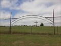
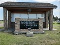
|   Trinity First Lutheran Cemetery - Stuttgart, KS Trinity First Lutheran Cemetery - Stuttgart, KS
in Worldwide Cemeteries Trinity First Lutheran Cemetery is on the south side of Highway 36 just west of Stuttgart, Kansas. posted by:  The Snowdog The Snowdog location: Kansas date approved: 01/18/2021 last visited: never |
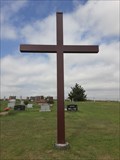 view gallery view galleryNE9.3 km |  Trinity First Lutheran Cemetery Cross - Stuttgart, KS Trinity First Lutheran Cemetery Cross - Stuttgart, KS
in Churchyard Crosses This plain steel Christian cross is at the northeast corner of Trinity First Lutheran Cemetery in Stuttgart, Kansas. posted by: The Snowdog location: Kansas date approved: 01/18/2021 last visited: never |
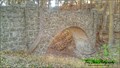
 view gallery view gallery E16.3 km E16.3 km
|  Phillipsburg City Park Pedestrian Stone Bridge - Phillipsburg, KS Phillipsburg City Park Pedestrian Stone Bridge - Phillipsburg, KS
in WPA Projects Located in the Phillipsburg City Park across from the restrooms and parking area. posted by: mr.volkswagen location: Kansas date approved: 11/12/2015 last visited: never |
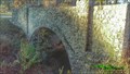
 view gallery view galleryE16.3 km |  Phillipsburg City Park Pedestrian Stone Bridge - Phillipsburg, KS Phillipsburg City Park Pedestrian Stone Bridge - Phillipsburg, KS
in Stone Bridges This pedestrian bridge goes from the Phillipsburg City park up to the Fort Bissell Campground. posted by: mr.volkswagen location: Kansas date approved: 11/11/2015 last visited: never |
 view gallery view galleryE16.3 km | Phillipsburg CityPark Road Stone Bridge - Phillipsburg, CO in Stone Bridges Located in the Phillipsburg City Park. You drive over this bridge to get to the campground on the hill. posted by: mr.volkswagen location: Colorado date approved: 11/19/2015 last visited: never |
 view gallery view galleryE16.3 km | Phillipsburg CityPark Road Stone Bridge - Phillipsburg, KS in WPA Projects Located in the Phillipsburg City Park. You drive over this bridge to get to the campground on the hill. posted by: mr.volkswagen location: Kansas date approved: 11/12/2015 last visited: never |
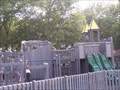 view gallery view galleryE16.3 km |  Phillipsburg City Park - Phillipsburg, KS Phillipsburg City Park - Phillipsburg, KS
in Public Playgrounds Park is located at west end of Phillipsburg. posted by: mr.volkswagen location: Kansas date approved: 07/18/2007 last visited: never |
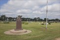 view gallery view galleryE18.2 km |  Philipsburg Veterans Memorial - Philipsburg, KS Philipsburg Veterans Memorial - Philipsburg, KS
in Non-Specific Veteran Memorials This simple veterans memorial is in the center of Fairview Cemetery in southeast Philipsburg, Kansas. posted by: The Snowdog location: Kansas date approved: 02/06/2021 last visited: never |
 view gallery view galleryE18.2 km | Fairview Cemetery - Philipsburg, KS in Worldwide Cemeteries Fairview Cemetery, final rest for about five thousand souls, is in southeast Philipsburg, Kansas. posted by: The Snowdog location: Kansas date approved: 01/17/2021 last visited: never |
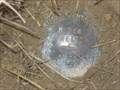 view gallery view gallery W31.5 km W31.5 km
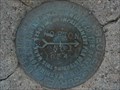
|  NGS M 364 RESET 1998, Kansas NGS M 364 RESET 1998, Kansas
in U.S. Benchmarks NGS M 364 RESET 1998, KS, is a Vertical Control Mark located about 0.1 miles south of the intersection of US Highway 283 and Road T about eight miles south of Norton, Norton County, KS. posted by:  seventhings seventhings location: Kansas date approved: 05/31/2006 last visited: never |
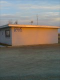 view gallery view galleryW31.9 km |  KQNK FM 106.7 & AM 1530 KQNK FM 106.7 & AM 1530
in A.M./F.M. Radio Broadcasting Stations This is Norton's local radio station. It plays "Classic Rock" and it's highlight is "The Party Line" every week-day starting at 9:00a. posted by: gpboutwell location: Kansas date approved: 03/06/2009 last visited: never |
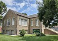 view gallery view galleryW33.5 km |  Norton County Historical Museum - Norton, KS Norton County Historical Museum - Norton, KS
in History Museums The Norton County Historical Museum is housed in the old Norton Public Library in Norton, Kansas. posted by: The Snowdog location: Kansas date approved: 01/07/2021 last visited: never |
 view gallery view galleryW33.5 km |  1938 - Norton Public Library, Norton, KS 1938 - Norton Public Library, Norton, KS
in Dated Buildings and Cornerstones The Norton Public Library building was constructed in 1938 - in Norton, Kansas. posted by: The Snowdog location: Kansas date approved: 01/07/2021 last visited: never |
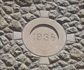
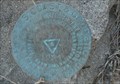
 view gallery view galleryW33.5 km | NORTON 1933 - Norton, KS in U.S. Benchmarks This U.S. Coast and Geodetic Survey benchmark disk is near the old Norton Public Library; in Norton, Kansas. posted by: The Snowdog location: Kansas date approved: 01/08/2021 last visited: 03/07/2022 |
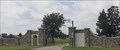
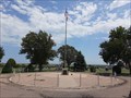 view gallery view gallery NW34 km NW34 km
| Norton Veterans Memorial - Norton, KS in Non-Specific Veteran Memorials This veterans memorial is the centerpiece of Norton Cemetery, on the northwest side of Norton, Kansas. posted by: The Snowdog location: Kansas date approved: 01/09/2021 last visited: never |
 view gallery view galleryNW34.1 km | Norton Cemetery - Norton, KS in Worldwide Cemeteries This large cemetery is on the north side of Norton, Kansas. posted by: The Snowdog location: Kansas date approved: 01/09/2021 last visited: never |
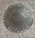
 view gallery view galleryW34.3 km | KG0827: Norton Municipal Tank - Norton KS in U.S. Benchmarks This Benchmark is the Water Tower on Warsaw Street and Jones Avenue in Norton, Kansas. posted by: PeterNoG location: Kansas date approved: 09/29/2013 last visited: 03/07/2022 |
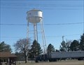 view gallery view galleryW34.3 km |  Water Tower - Norton KS Water Tower - Norton KS
in Water Towers This Water Tower is at Warsaw Street and Jones Avenue in Norton, Kansas. posted by: PeterNoG location: Kansas date approved: 10/01/2013 last visited: 03/07/2022 |
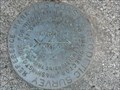 view gallery view galleryW34.3 km | KG0518: NORTON RM2 - Norton KS in U.S. Benchmarks This Benchmark is 60 feet southwest of the Water Tower on Warsaw Street and Jones Avenue in Norton, Kansas. posted by: PeterNoG location: Kansas date approved: 12/24/2013 last visited: 08/06/2020 |
 view gallery view galleryW34.3 km | KG0518: NORTON RM1 - Norton KS in U.S. Benchmarks This Benchmark is 60 feet northwest of the Water Tower on Warsaw Street and Jones Avenue in Norton, Kansas. posted by: PeterNoG location: Kansas date approved: 12/24/2013 last visited: 08/06/2020 |
 view gallery view galleryW34.3 km | KG0518: NORTON - Norton KS in U.S. Benchmarks This Benchmark is just west of the Water Tower on Warsaw Street and Jones Avenue in Norton, Kansas. posted by: PeterNoG location: Kansas date approved: 09/29/2013 last visited: 03/07/2022 |
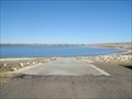
 view gallery view gallery S35.4 km S35.4 km
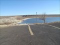
|  Rock Point Ramp - Webster State Park, KS Rock Point Ramp - Webster State Park, KS
in Boat Ramps Double lane ramp on north side of Webster Reservoir. posted by: Kansas Stasher location: Kansas date approved: 12/22/2006 last visited: never |
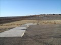 view gallery view galleryS36.9 km | Old Marina Ramp - Webster State Park, KS in Boat Ramps Double lane ramp on north side of Webster Reservoir. posted by: Kansas Stasher location: Kansas date approved: 12/22/2006 last visited: never |
 view gallery view galleryS37.3 km | Goose Flat Ramp - Webster State Park, KS in Boat Ramps Single lane ramp on south side of Webster Reservoir. posted by: Kansas Stasher location: Kansas date approved: 12/22/2006 last visited: never |
 view gallery view galleryS37.8 km |  Nicodemus Nicodemus
in Kansas Historical Markers The town of Nicodemus was a planned community devoted to Black settlement in the years after the U.S. Civil War. posted by: Kansas Stasher location: Kansas date approved: 10/21/2006 last visited: 05/10/2023 |
|