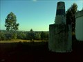
![Image for Cruzeiro da Amêndoa [Mação]](https://img.geocaching.com/waymarking/small/dbc3df8b-2c11-44fc-9d6e-b91eefbfa257.bmp) view gallery view gallery SW3.9 km SW3.9 km
|   Cruzeiro da Amêndoa [Mação] Cruzeiro da Amêndoa [Mação]
in Christian Crosses cruzeiro da Amêndoa foi erigido em 1940 para comemoração 8º centenário da Independência de Portugal e para celebração do 3º centenário da Restauração da Independência em 1640. posted by:  h_raky h_raky location: Santarém, Portugal date approved: 10/31/2010 last visited: 10/07/2015 |
 view gallery view gallery W7.6 km W7.6 km
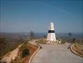
|  Centro Geodésico de Portugal Centro Geodésico de Portugal
in Geographical Centers The municipality of Vila de Rei is covered by large pine areas and it's located precisely in the middle of Portugal, geographically speaking. posted by:  btrodrigues btrodrigues location: Castelo Branco, Portugal date approved: 05/06/2010 last visited: 02/25/2012 |
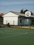 view gallery view galleryW9 km |  Street Basketball Court in Vila de Rei Street Basketball Court in Vila de Rei
in Outdoor Basketball Courts A Street Basketball Court in Vila de Rei, Portugal posted by: Team Marretas location: Castelo Branco, Portugal date approved: 05/08/2012 last visited: 11/03/2013 |
![Image for Ecopista do Ramal de Évora-Mora - [Arraiolos, Évora, Portugal]](https://img.geocaching.com/waymarking/small/b28a8beb-5a09-4dd3-b849-0528685a1d01.JPG) view gallery view gallery NE11.1 km NE11.1 km
|  Ecopista do Ramal de Évora-Mora - [Arraiolos, Évora, Portugal] Ecopista do Ramal de Évora-Mora - [Arraiolos, Évora, Portugal]
in Rails to Trails The conversion of the former rail extension in ECOPISTA arises from an agreement between REFER and Évora City Council with a view to integration into the network of cycle paths and pedestrian paths. posted by: viperunderground location: Évora, Portugal date approved: 11/27/2011 last visited: 05/13/2013 |
 view gallery view galleryW19.8 km |  Besteira, Ferreira do Zezere, Portugal Besteira, Ferreira do Zezere, Portugal
in Portugal Geodetic Points A VG in Ferreira do Zezere region. posted by: Torgut location: Santarém, Portugal date approved: 06/19/2012 last visited: 04/14/2013 |
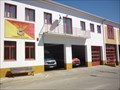 view gallery view galleryW21.1 km |  B.V. Ferreira do Zêzere, Portugal B.V. Ferreira do Zêzere, Portugal
in Firehouses This fire unit has a hard operational area, with lots of forest wildfires during the hot and dry season, typically between June and September posted by: Torgut location: Leiria, Portugal date approved: 09/25/2011 last visited: 06/22/2013 |
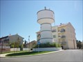 view gallery view galleryW21.4 km |  Water Tower, Ferreira do Zêzere, Portugal Water Tower, Ferreira do Zêzere, Portugal
in Water Towers A beautiful, tiny and properly painted water tower in the small town of Ferreira do Zêzere in Portugal. posted by: Torgut location: Leiria, Portugal date approved: 09/20/2011 last visited: 04/14/2013 |
 view gallery view gallery NW21.4 km NW21.4 km
|  Torre de Dornes - Ferreira do Zezere, Portugal Torre de Dornes - Ferreira do Zezere, Portugal
in Wikipedia Entries Dornes tower is an old Templar Tower located in Dornes, center of Portugal. posted by: manchanegra location: Santarém, Portugal date approved: 07/27/2011 last visited: 10/23/2011 |
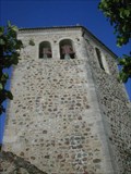 view gallery view galleryNW21.4 km |  Torre de Dornes - Ferreira do Zezere, Portugal Torre de Dornes - Ferreira do Zezere, Portugal
in Bell Towers Dornes tower is an old Templar Tower located in Dornes, center of Portugal. posted by: manchanegra location: Santarém, Portugal date approved: 07/27/2011 last visited: 10/23/2011 |
 view gallery view galleryNW21.4 km | ") Torre de Dornes - Ferreira do Zezere, Portugal Torre de Dornes - Ferreira do Zezere, Portugal
in Património Português (Portuguese Heritage) Dornes tower is an old Templar Tower located in Dornes, center of Portugal. posted by: manchanegra location: Santarém, Portugal date approved: 07/28/2011 last visited: 10/23/2011 |
 view gallery view galleryW21.7 km |  Águas Belas spring, Ferreira do Zêzere, Portugal Águas Belas spring, Ferreira do Zêzere, Portugal
in Natural Springs Spring dated from 1940 in the boundaries of Ferreira do Zêzere, Portugal posted by: Torgut location: Leiria, Portugal date approved: 09/20/2011 last visited: 10/30/2011 |
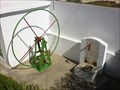 view gallery view galleryW22.2 km |  Fonte do Casalinho, Ferreira do Zêzere, Portugal Fonte do Casalinho, Ferreira do Zêzere, Portugal
in Hand Operated Water Pumps A beautifully renovated water pump in Ferreira do Zêzere posted by: Torgut location: Leiria, Portugal date approved: 09/20/2011 last visited: 02/17/2015 |
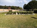 view gallery view galleryW22.2 km |  "Bemvindo" - Ferreira do Zêzere, Portugal "Bemvindo" - Ferreira do Zêzere, Portugal
in Readable From Above In one of the roundabouts, Ferreira do Zêzere welcomes every driver. posted by: tofixe location: Santarém, Portugal date approved: 04/23/2018 last visited: never |
 view gallery view galleryW22.2 km |  Bemvindo - Ferreira do Zêzere, Portugal Bemvindo - Ferreira do Zêzere, Portugal
in Topiaries Bushes cuted to form the word "Bemvindo" in Ferreira do Zêzere. posted by: tofixe location: Santarém, Portugal date approved: 05/20/2018 last visited: never |
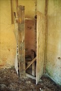 view gallery view galleryW22.4 km |  Backhouse of an old bakery, Ferreira do Zêzere, Portugal Backhouse of an old bakery, Ferreira do Zêzere, Portugal
in Outhouses In the back of an old building, an unexpected privy posted by: Torgut location: Santarém, Portugal date approved: 09/21/2011 last visited: 10/23/2011 |
 view gallery view galleryW22.5 km |  Ferreira do Zêzere, Portugal Ferreira do Zêzere, Portugal
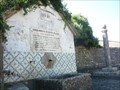
in Sister City Monuments A placard presenting the bonds officially established between the town of Ferreira do Zêzere in Portugal and Fieni in Romania. Also referenced a bond with Viana do Alentejo, in Portugal posted by: Torgut location: Leiria, Portugal date approved: 09/18/2011 last visited: 10/29/2011 |
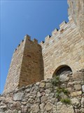 view gallery view gallery S22.9 km S22.9 km
| Castelo de Belver - Belver, Portugal in Património Português (Portuguese Heritage) The Castle of Belver was declared as a National Monument in 1910 posted by: tmob location: Portalegre, Portugal date approved: 02/04/2012 last visited: 07/07/2012 |
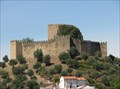 view gallery view galleryS22.9 km |  Castelo de Belver - Belver, Gavião, Portugal Castelo de Belver - Belver, Gavião, Portugal
in Castles Magnificent castle posted by: Daveira Family location: Portalegre, Portugal date approved: 11/12/2010 last visited: 04/10/2011 |
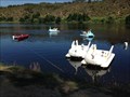 view gallery view galleryS23.2 km | ") Praia do Alamal - Gavião, Portugal Praia do Alamal - Gavião, Portugal
in Watercraft Rentals (Human Powered) Nice place to rent a human powered watercraft. posted by: tofixe location: Portalegre, Portugal date approved: 08/31/2015 last visited: never |
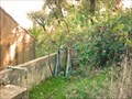 view gallery view galleryNW24.8 km | Old Water Pump. Dornes, Portugal in Hand Operated Water Pumps An old but operative water pump not far from Dornes posted by: Torgut location: Leiria, Portugal date approved: 09/20/2011 last visited: 10/30/2011 |
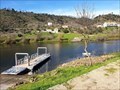 view gallery view gallery SE25.6 km SE25.6 km
|  Barca da Amieira - Amieira do Alentejo, Portugal Barca da Amieira - Amieira do Alentejo, Portugal
in Ferries and Ferry Landings This is a historical cross, it was suspended and recently rehabilitated by the municipality posted by: Torgut location: Portalegre, Portugal date approved: 12/17/2019 last visited: never |
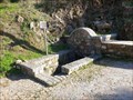 view gallery view gallerySE25.7 km | Fonte dos Amores - Amieira do Tejo, Portugal in Natural Springs This spring is located near a historical cross of the Tagus river, not far from the village of Amieira do Tejo. posted by: Torgut location: Portalegre, Portugal date approved: 12/17/2019 last visited: never |
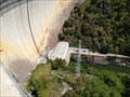 view gallery view gallery N26.6 km N26.6 km
|  Estação hidroelétrica do Cabril - Leiria, Portugal Estação hidroelétrica do Cabril - Leiria, Portugal
in Hydroelectric Power Stations A hydroelectric power station in Zêzere River. posted by: tofixe location: Leiria, Portugal date approved: 05/28/2018 last visited: 05/06/2023 |
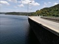 view gallery view galleryN26.6 km |  Barragem do Cabril Barragem do Cabril
in Water Dams One of the biggest water dam in Portugal. posted by: tofixe location: Leiria, Portugal date approved: 07/13/2018 last visited: never |
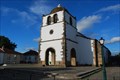 view gallery view galleryN26.9 km | Igreja de Nossa Senhora da Assunção - Pedrogão Grande, Portugal in Património Português (Portuguese Heritage) Igreja de Nossa Senhora da Assunção is a Catholic temple in Pedrogão Grande. posted by: manchanegra location: Leiria, Portugal date approved: 11/25/2011 last visited: 06/04/2010 |
|