 view gallery view gallery N6.8 km N6.8 km
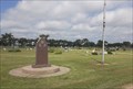
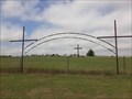
|   Philipsburg Veterans Memorial - Philipsburg, KS Philipsburg Veterans Memorial - Philipsburg, KS
in Non-Specific Veteran Memorials This simple veterans memorial is in the center of Fairview Cemetery in southeast Philipsburg, Kansas. posted by:  The Snowdog The Snowdog location: Kansas date approved: 02/06/2021 last visited: never |
 view gallery view galleryN7.1 km |  Fairview Cemetery - Philipsburg, KS Fairview Cemetery - Philipsburg, KS
in Worldwide Cemeteries Fairview Cemetery, final rest for about five thousand souls, is in southeast Philipsburg, Kansas. posted by: The Snowdog location: Kansas date approved: 01/17/2021 last visited: never |
 view gallery view galleryN8 km |  Phillipsburg CityPark Road Stone Bridge - Phillipsburg, CO Phillipsburg CityPark Road Stone Bridge - Phillipsburg, CO
in Stone Bridges Located in the Phillipsburg City Park. You drive over this bridge to get to the campground on the hill. posted by: mr.volkswagen location: Colorado date approved: 11/19/2015 last visited: never |
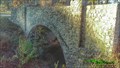 view gallery view galleryN8 km |  Phillipsburg CityPark Road Stone Bridge - Phillipsburg, KS Phillipsburg CityPark Road Stone Bridge - Phillipsburg, KS
in WPA Projects Located in the Phillipsburg City Park. You drive over this bridge to get to the campground on the hill. posted by: mr.volkswagen location: Kansas date approved: 11/12/2015 last visited: never |
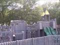 view gallery view galleryN8 km |  Phillipsburg City Park - Phillipsburg, KS Phillipsburg City Park - Phillipsburg, KS
in Public Playgrounds Park is located at west end of Phillipsburg. posted by: mr.volkswagen location: Kansas date approved: 07/18/2007 last visited: never |
 view gallery view galleryN8.2 km | Phillipsburg City Park Pedestrian Stone Bridge - Phillipsburg, KS in WPA Projects Located in the Phillipsburg City Park across from the restrooms and parking area. posted by: mr.volkswagen location: Kansas date approved: 11/12/2015 last visited: never |
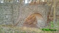 view gallery view galleryN8.2 km | Phillipsburg City Park Pedestrian Stone Bridge - Phillipsburg, KS in Stone Bridges This pedestrian bridge goes from the Phillipsburg City park up to the Fort Bissell Campground. posted by: mr.volkswagen location: Kansas date approved: 11/11/2015 last visited: never |
 view gallery view gallery NW18.7 km NW18.7 km
| Trinity First Lutheran Cemetery - Stuttgart, KS in Worldwide Cemeteries Trinity First Lutheran Cemetery is on the south side of Highway 36 just west of Stuttgart, Kansas. posted by: The Snowdog location: Kansas date approved: 01/18/2021 last visited: never |
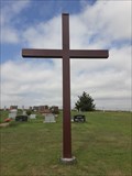 view gallery view galleryNW18.7 km |  Trinity First Lutheran Cemetery Cross - Stuttgart, KS Trinity First Lutheran Cemetery Cross - Stuttgart, KS
in Churchyard Crosses This plain steel Christian cross is at the northeast corner of Trinity First Lutheran Cemetery in Stuttgart, Kansas. posted by: The Snowdog location: Kansas date approved: 01/18/2021 last visited: never |
 view gallery view gallery S27.7 km S27.7 km
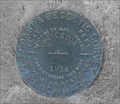
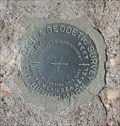
|  KG0267 STOCKTON 1934 - Stockton, KS KG0267 STOCKTON 1934 - Stockton, KS
in U.S. Benchmarks This U.S. Coast and Geodetic Survey Benchmark Disk is on the left side of the north entrance to the Rooks County Courthouse in Stockton, Kansas. posted by: The Snowdog location: Kansas date approved: 01/11/2021 last visited: never |
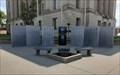 view gallery view galleryS27.7 km | Rooks County Veterans Memorial - Stockton, KS in Non-Specific Veteran Memorials The Rooks County Veterans Memorial is in the northeast corner of the County Courthouse Square in Stockton, Kansas. posted by: The Snowdog location: Kansas date approved: 01/09/2021 last visited: 05/03/2023 |
 view gallery view galleryS27.7 km |  Rooks County Courthouse - 1921 - Stockton, KS Rooks County Courthouse - 1921 - Stockton, KS
in Dated Architectural Structures Multifarious The plaques attached to the cornerstone of the Rooks County Courthouse give the date of construction as 1921 - in Stockton, Kansas. posted by: The Snowdog location: Kansas date approved: 01/08/2021 last visited: 06/09/2021 |
 view gallery view galleryS27.7 km |  Rooks County Courthouse - Stockton, KS Rooks County Courthouse - Stockton, KS
in Courthouses This striking Classical Revival courthouse serves Rooks County; in Stockton, Kansas. posted by: The Snowdog location: Kansas date approved: 01/10/2021 last visited: never |
 view gallery view galleryS28 km | N 161 (KG0303) - Stockton, KS in U.S. Benchmarks This U.S. Coast and Geodetic Survey Benchmark Disk is set in a concrete culvert - in Stockton, Kansas. posted by: The Snowdog location: Kansas date approved: 04/19/2024 last visited: never |
 view gallery view gallery SE31.4 km SE31.4 km
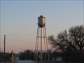
|  WOODSTON - Water Tank WOODSTON - Water Tank
in Water Towers Woodston Water Tank Woodston, Kansas posted by:  GEO*Trailblazer 1 GEO*Trailblazer 1 location: Kansas date approved: 03/18/2008 last visited: 03/19/2008 |
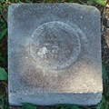 view gallery view gallerySE31.7 km | Woodston Cemetery benchmark in U.S. Benchmarks This benchmark is next to the NE corner of the Woodston, KS cemetery. posted by: Rotareneg location: Kansas date approved: 09/30/2010 last visited: 08/06/2020 |
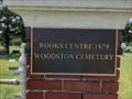 view gallery view gallerySE31.7 km | Woodston Cemetery - Woodston, KS in Worldwide Cemeteries This small and well-tended cemetery is southwest of Woodston, Kansas. posted by: The Snowdog location: Kansas date approved: 01/10/2021 last visited: never |
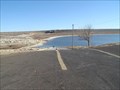 view gallery view galleryS31.7 km |  Rock Point Ramp - Webster State Park, KS Rock Point Ramp - Webster State Park, KS
in Boat Ramps Double lane ramp on north side of Webster Reservoir. posted by: Kansas Stasher location: Kansas date approved: 12/22/2006 last visited: never |
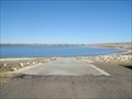 view gallery view galleryS33.3 km | Goose Flat Ramp - Webster State Park, KS in Boat Ramps Single lane ramp on south side of Webster Reservoir. posted by: Kansas Stasher location: Kansas date approved: 12/22/2006 last visited: never |
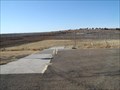 view gallery view galleryS34.1 km | Old Marina Ramp - Webster State Park, KS in Boat Ramps Double lane ramp on north side of Webster Reservoir. posted by: Kansas Stasher location: Kansas date approved: 12/22/2006 last visited: never |
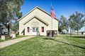
 view gallery view gallerySE39.4 km |  CUSTER LODGE 166 FLT IOOF CUSTER LODGE 166 FLT IOOF
in Odd Fellow Lodges Custer Lodge 166 FLT IOOF Alton, Kansas posted by: GEO*Trailblazer 1 location: Kansas date approved: 04/08/2008 last visited: 04/08/2008 |
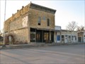
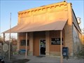 view gallery view gallerySE39.4 km |  Alton, Kansas 67623 Alton, Kansas 67623
in U.S. Post Offices Post Office at Alton, Kansas 67623 "BULL CITY" posted by: GEO*Trailblazer 1 location: Kansas date approved: 04/08/2008 last visited: 04/08/2008 |
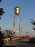 view gallery view gallerySE39.6 km | ALTON - Water Tank in Water Towers Alton Water Tank Alton, Kansas posted by: GEO*Trailblazer 1 location: Kansas date approved: 03/18/2008 last visited: 03/18/2008 |
 view gallery view gallery SW41.7 km SW41.7 km
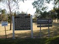
|  Nicodemus Nicodemus
in Kansas Historical Markers The town of Nicodemus was a planned community devoted to Black settlement in the years after the U.S. Civil War. posted by: Kansas Stasher location: Kansas date approved: 10/21/2006 last visited: 05/10/2023 |
 view gallery view gallerySW41.7 km |  Nicodemus Historic District - Nicodemus KS Nicodemus Historic District - Nicodemus KS
in U.S. National Register of Historic Places Nicodemus National Historic Site, located in Nicodemus, Kansas, United States, preserves, protects and interprets the only remaining western town established by African Americans during the Reconstruction Period following the American Civil War. posted by: nomadwillie location: Kansas date approved: 07/16/2018 last visited: 05/10/2023 |
|