 view gallery view gallery NW9.2 km NW9.2 km
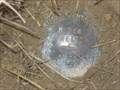
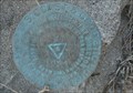
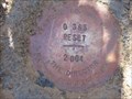
|   NGS M 364 RESET 1998, Kansas NGS M 364 RESET 1998, Kansas
in U.S. Benchmarks NGS M 364 RESET 1998, KS, is a Vertical Control Mark located about 0.1 miles south of the intersection of US Highway 283 and Road T about eight miles south of Norton, Norton County, KS. posted by:  seventhings seventhings location: Kansas date approved: 05/31/2006 last visited: never |
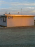 view gallery view gallery N19.2 km N19.2 km
|  KQNK FM 106.7 & AM 1530 KQNK FM 106.7 & AM 1530
in A.M./F.M. Radio Broadcasting Stations This is Norton's local radio station. It plays "Classic Rock" and it's highlight is "The Party Line" every week-day starting at 9:00a. posted by: gpboutwell location: Kansas date approved: 03/06/2009 last visited: never |
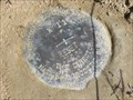
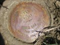
 view gallery view galleryN19.8 km | NORTON 1933 - Norton, KS in U.S. Benchmarks This U.S. Coast and Geodetic Survey benchmark disk is near the old Norton Public Library; in Norton, Kansas. posted by:  The Snowdog The Snowdog location: Kansas date approved: 01/08/2021 last visited: 03/07/2022 |
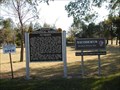
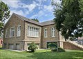 view gallery view galleryN19.8 km |  Norton County Historical Museum - Norton, KS Norton County Historical Museum - Norton, KS
in History Museums The Norton County Historical Museum is housed in the old Norton Public Library in Norton, Kansas. posted by: The Snowdog location: Kansas date approved: 01/07/2021 last visited: never |
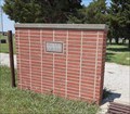
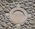 view gallery view galleryN19.8 km |  1938 - Norton Public Library, Norton, KS 1938 - Norton Public Library, Norton, KS
in Dated Buildings and Cornerstones The Norton Public Library building was constructed in 1938 - in Norton, Kansas. posted by: The Snowdog location: Kansas date approved: 01/07/2021 last visited: never |
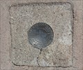
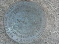 view gallery view galleryN20.8 km | KG0518: NORTON RM2 - Norton KS in U.S. Benchmarks This Benchmark is 60 feet southwest of the Water Tower on Warsaw Street and Jones Avenue in Norton, Kansas. posted by: PeterNoG location: Kansas date approved: 12/24/2013 last visited: 08/06/2020 |
 view gallery view galleryN20.8 km | KG0827: Norton Municipal Tank - Norton KS in U.S. Benchmarks This Benchmark is the Water Tower on Warsaw Street and Jones Avenue in Norton, Kansas. posted by: PeterNoG location: Kansas date approved: 09/29/2013 last visited: 03/07/2022 |
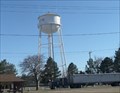 view gallery view galleryN20.8 km |  Water Tower - Norton KS Water Tower - Norton KS
in Water Towers This Water Tower is at Warsaw Street and Jones Avenue in Norton, Kansas. posted by: PeterNoG location: Kansas date approved: 10/01/2013 last visited: 03/07/2022 |
 view gallery view galleryN20.8 km | KG0518: NORTON RM1 - Norton KS in U.S. Benchmarks This Benchmark is 60 feet northwest of the Water Tower on Warsaw Street and Jones Avenue in Norton, Kansas. posted by: PeterNoG location: Kansas date approved: 12/24/2013 last visited: 08/06/2020 |
 view gallery view galleryN20.8 km | KG0518: NORTON - Norton KS in U.S. Benchmarks This Benchmark is just west of the Water Tower on Warsaw Street and Jones Avenue in Norton, Kansas. posted by: PeterNoG location: Kansas date approved: 09/29/2013 last visited: 03/07/2022 |
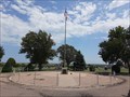 view gallery view galleryN21.4 km |  Norton Veterans Memorial - Norton, KS Norton Veterans Memorial - Norton, KS
in Non-Specific Veteran Memorials This veterans memorial is the centerpiece of Norton Cemetery, on the northwest side of Norton, Kansas. posted by: The Snowdog location: Kansas date approved: 01/09/2021 last visited: never |
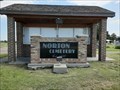 view gallery view galleryN21.4 km |  Norton Cemetery - Norton, KS Norton Cemetery - Norton, KS
in Worldwide Cemeteries This large cemetery is on the north side of Norton, Kansas. posted by: The Snowdog location: Kansas date approved: 01/09/2021 last visited: never |
 view gallery view gallery S24.6 km S24.6 km
| NGS X 11 RESET 2004, Kansas in U.S. Benchmarks NGS X 11 RESET 2004, KS, is a Vertical Control Mark located at the intersection of US Highway 283 and V Road about five miles north of Hill City, Graham County, KS. posted by: seventhings location: Kansas date approved: 05/31/2006 last visited: never |
 view gallery view gallery W25.9 km W25.9 km
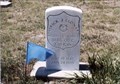
|  Patrick J. Leonard-New Almelo, KS Patrick J. Leonard-New Almelo, KS
in Medal Of Honor Resting Places Indian Campaigns Medal of Honor Recipient for action at Little Blue NE on May 15, 1870. He is buried in Saint Joseph Cemetery, New Almelo, KS in Section D posted by: Don.Morfe location: Kansas date approved: 05/21/2018 last visited: 12/13/2021 |
 view gallery view galleryS27.8 km | NGS G 365 RESET 2004, Kansas in U.S. Benchmarks NGS G 365 RESET 2004, KS, is a Vertical Control Mark located near the intersection of US Highway 283 and T Road about three miles north of Hill City, Graham County, KS. posted by: seventhings location: Kansas date approved: 05/31/2006 last visited: never |
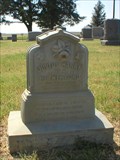 view gallery view galleryS29.5 km |  Justus Retherford - Hill City Cemetery, Graham Co., Kansas Justus Retherford - Hill City Cemetery, Graham Co., Kansas
in Zinc Headstones A small zinc marker for Justus Harry Retherford located in Hill City Cemetery, near Hill City, Graham Co., Kansas. posted by: fizzbomb location: Kansas date approved: 07/03/2008 last visited: never |
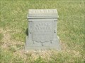 view gallery view galleryS29.5 km | William J. Booth - Hill City Cemetery, Graham County, Kansas in Zinc Headstones A zinc marker for William J. Boothe located in Hill City Cemetery, near Hill City, Graham Co., Kansas. posted by: fizzbomb location: Kansas date approved: 07/03/2008 last visited: never |
 view gallery view galleryS29.6 km | Hill City Cemetery - Hill City, KS in Worldwide Cemeteries Hill City Cemetery, final rest for about four thousand souls, is north of Hill City, Kansas. posted by: The Snowdog location: Kansas date approved: 01/09/2021 last visited: never |
 view gallery view galleryS31.2 km | NGS F 365 RESET 2004, Nebraska in U.S. Benchmarks NGS F 365 RESET 2004 is a Vertical Control Mark located at the intersection of US Highway 283 and R Road about one mile north of Hill City, Graham County, KS. posted by: seventhings location: Kansas date approved: 05/31/2006 last visited: never |
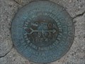
 view gallery view galleryS32.8 km | HILL CITY (KG0316) - Hill City, KS in U.S. Benchmarks This U.S. Coast and Geodetic Survey Benchmark Disk is set in the concrete at a street corner - in Hill City, Kansas. posted by: The Snowdog location: Kansas date approved: 04/19/2024 last visited: never |
 view gallery view galleryS33.2 km |  Welcome to Hill City - Hill City, KS Welcome to Hill City - Hill City, KS
in Welcome Signs This "Welcome to Hill City" sign also proclaims the city as "Ringneck Country" - in Hill City, Kansas. posted by: The Snowdog location: Kansas date approved: 01/10/2021 last visited: never |
 view gallery view galleryS33.2 km |  Rotary International - Hill City, KS Rotary International - Hill City, KS
in Rotary International Markers The "Rotary International" symbol appears on this welcome sign in Hill City, Kansas. posted by: The Snowdog location: Kansas date approved: 01/09/2021 last visited: never |
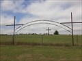
 view gallery view gallery NE34.3 km NE34.3 km
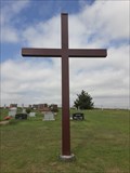
|  Trinity First Lutheran Cemetery Cross - Stuttgart, KS Trinity First Lutheran Cemetery Cross - Stuttgart, KS
in Churchyard Crosses This plain steel Christian cross is at the northeast corner of Trinity First Lutheran Cemetery in Stuttgart, Kansas. posted by: The Snowdog location: Kansas date approved: 01/18/2021 last visited: never |
 view gallery view galleryNE34.3 km | Trinity First Lutheran Cemetery - Stuttgart, KS in Worldwide Cemeteries Trinity First Lutheran Cemetery is on the south side of Highway 36 just west of Stuttgart, Kansas. posted by: The Snowdog location: Kansas date approved: 01/18/2021 last visited: never |
 view gallery view gallery SE34.4 km SE34.4 km
|  Nicodemus Nicodemus
in Kansas Historical Markers The town of Nicodemus was a planned community devoted to Black settlement in the years after the U.S. Civil War. posted by: Kansas Stasher location: Kansas date approved: 10/21/2006 last visited: 05/10/2023 |
|