 view gallery view gallery W0.3 km W0.3 km
|   Bear Creek Trout Hatchery and Rearing Station Garrett County Bear Creek Trout Hatchery and Rearing Station Garrett County
in Maryland Historical Markers Located at the intersection of Bear Creek Road and route 219. posted by:  flyingmoose flyingmoose location: Maryland date approved: 09/17/2006 last visited: never |
 view gallery view gallery SW2.7 km SW2.7 km
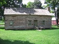
|  Drane House - Accident MD Drane House - Accident MD
in Homesteads Found off US Route 219, east of the town of Accident, Maryland, the Drane House is believed to be the oldest standing structure in Garrett County, MD. Signs on US 219 indicate the location of the house. posted by: HaricotVert_52 location: Maryland date approved: 08/05/2008 last visited: 03/27/2011 |
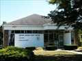 view gallery view gallerySW3.2 km |  Accident, Maryland 21520 Accident, Maryland 21520
in U.S. Post Offices This stand alone post office serves the small town of Accident, Maryland. posted by: miatabug location: Maryland date approved: 10/16/2009 last visited: 08/08/2015 |
 view gallery view gallery NE6.4 km NE6.4 km
|  McDonald's #11951 - I-68, Exit 14 - Keyser's Ridge, Maryland McDonald's #11951 - I-68, Exit 14 - Keyser's Ridge, Maryland
in McDonald's Restaurants This McDonald's is located at 4098 National Pike (ALT US 40) near Exit 14 of Interstate 68 in rural Garrett County, Maryland posted by:  outdoorboy34 outdoorboy34 location: Maryland date approved: 08/19/2013 last visited: 02/10/2021 |
 view gallery view galleryNE6.4 km |  Keyser’s Ridge - Living with Extreme Weather - Keyser's Ridge, Maryland Keyser’s Ridge - Living with Extreme Weather - Keyser's Ridge, Maryland
in U.S. 40 - The National Road This America's Byways Placed Marker is located at the entrance to the Keyser's Ridge McDonald's (4098 National Pike / ALT US Rte. 40) in Garrett County Maryland near Interchange 14 of Interstate 68 posted by: outdoorboy34 location: Maryland date approved: 07/26/2013 last visited: never |
 view gallery view gallery NW7.4 km NW7.4 km
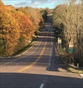
|  Youghiogheny Overlook Rest Area - I-68 EB - Friendsville, MD Youghiogheny Overlook Rest Area - I-68 EB - Friendsville, MD
in Highway Rest Areas Located on eastbound I-68, 1.5 miles east of Friendsville in Garrett County, Maryland, this site offers an outstanding view of the Youghiogheny reservoir. posted by: outdoorboy34 location: Maryland date approved: 01/22/2017 last visited: 09/12/2022 |
 view gallery view galleryNW7.4 km |  Youghiogheny Overlook - Friendsville, Maryland Youghiogheny Overlook - Friendsville, Maryland
in Scenic Roadside Look-Outs Overlook at Maryland Welcome Center on I-68 Eastbound wast of Friendsville, Maryland. posted by:  BruceS BruceS location: Maryland date approved: 11/08/2013 last visited: 09/12/2022 |
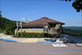 view gallery view galleryNW7.4 km |  Youghiogheny Overlook Welcome Center - Highway I-68, Maryland Youghiogheny Overlook Welcome Center - Highway I-68, Maryland
in Tourist Information Centers - Visitor Centers a tourist information center located on Highway I-68, eastbound, some 1.5 miles east of Friendsville, Maryland posted by: oiseau_ca location: Maryland date approved: 07/24/2017 last visited: 09/12/2022 |
 view gallery view gallery N7.4 km N7.4 km
| Bear Camp - Keyser's Ridge, Md in Maryland Historical Markers This marker is located along US-40 about a mile west of Keyser's Ridge, MD. posted by: onfire4jesus location: Maryland date approved: 02/12/2013 last visited: 11/11/2023 |
 view gallery view galleryN8 km |  Maryland/Pennsylvania Crossing via US 40 Maryland/Pennsylvania Crossing via US 40
in Border Crossings State Crossing along The National Road (US 40) just N of Pigs Ear RD. posted by: Ernmark location: Maryland date approved: 10/30/2019 last visited: never |
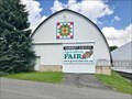
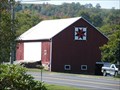 view gallery view gallerySW8 km |  Quilt Barn US 219 Accident, Maryland Quilt Barn US 219 Accident, Maryland
in Painted Barn Quilts This two-colored star pattern is painted on a barn west of Accident, Maryland on US 219. posted by: miatabug location: Maryland date approved: 10/17/2009 last visited: 04/08/2021 |
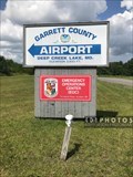 view gallery view gallery S8 km S8 km
|  Garrett County Airport elevation 2,933 feet - Accident, Maryland Garrett County Airport elevation 2,933 feet - Accident, Maryland
in Elevation Signs The Garrett County Airport entrance sign at the junction of Airport Road and Bumble Bee Road in Accident, Maryland, lists an elevation of 2,933 feet. That is the official measurement at Runway 9; the elevation at the sign is about 120 feet lower. posted by: 401Photos location: Maryland date approved: 07/15/2019 last visited: never |
 view gallery view galleryN8 km |  National Road National Road
in Pennsylvania Historical Markers U S Route 40 our first national road! posted by: Gosffo location: Pennsylvania date approved: 10/24/2009 last visited: 10/13/2021 |
 view gallery view galleryN8 km | Pennsylvania in Pennsylvania Historical Markers Hey did you forget I'm here?????? posted by: Gosffo location: Pennsylvania date approved: 10/24/2009 last visited: 11/11/2023 |
 view gallery view galleryN8 km | Dixie Motel, on the Mason Dixon Line in U.S. 40 - The National Road Old six room motel located at the bend of the road, on top of the hill. The Mason Dixon line is right behind it and you can see the old monument and stone pile. The motel was built in 1950. posted by: kbarhow location: Pennsylvania date approved: 12/30/2008 last visited: 05/10/2010 |
 view gallery view galleryS8.2 km |  Dog Sledding mailbox - Accident, Maryland USA Dog Sledding mailbox - Accident, Maryland USA
in Themed Homemade Mailboxes This mushing-themed mailbox covered in license plates, sled signs, and dog tags is on the northwest side of Bumble Bee Road in Accident, Maryland. It is incorporated with a double-sided, handmade Dog Sled Crossing sign. posted by: 401Photos location: Maryland date approved: 07/13/2019 last visited: never |
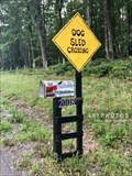 view gallery view galleryS8.2 km |  Dog Sled Crossing - Accident, Maryland USA Dog Sled Crossing - Accident, Maryland USA
in Uncommon Crossing Signs This double-sided, handmade Dog Sled Crossing sign is on the northwest side of Bumble Bee Road in Accident, Maryland. posted by: 401Photos location: Maryland date approved: 07/13/2019 last visited: never |
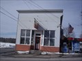 view gallery view gallery SE8.2 km SE8.2 km
| Bittinger MD 21522 Post Office in U.S. Post Offices Bittinger MD 21522 Post Office posted by: dukemartin location: Maryland date approved: 02/05/2014 last visited: never |
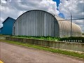 view gallery view gallerySW8.2 km |  Garrett County Airport Quonset hut - Accident, Maryland Garrett County Airport Quonset hut - Accident, Maryland
in Quonset Huts A Quonset hut is along the drive from Bumble Bee Road up Airport Road to Garrett County Airport in Accident, Maryland. posted by: 401Photos location: Maryland date approved: 07/20/2019 last visited: never |
 view gallery view gallerySW8.2 km | Garrett County Fairground Quonset Huts - McHenry, Maryland in Quonset Huts The Garrett County Agriculture Fair has a pair of Emkay Quonset huts on the southwest border of the fairgrounds. They serve as exhibition halls. posted by: 401Photos location: Maryland date approved: 07/20/2019 last visited: never |
 view gallery view gallerySW8.4 km |  Garrett County Airport - Accident, MD Garrett County Airport - Accident, MD
in Airports Garrett County Airport is a general aviation airport in western Maryland. It has a single, 5,000-foot runway which is staffed from 8:00am - 6:00pm daily and is open 24/7. The facility is named - Lt. Col. Robert "Bob" E. Railey USAF DCANG Terminal. posted by: 401Photos location: Maryland date approved: 07/13/2019 last visited: never |
 view gallery view gallerySW8.4 km |  Garrett County Airport guest book - Accident, Maryland. USA Garrett County Airport guest book - Accident, Maryland. USA
in Guest Books Garrett County Airport is a general aviation airport in western Maryland. It has a single, 5,000-foot runway which is staffed from 8:00am - 6:00pm daily and is open 24/7. The guest book is on a small podium near the doors that lead to the apron. posted by: 401Photos location: Maryland date approved: 07/14/2019 last visited: never |
 view gallery view galleryW9.3 km |  Friendsville Vol. Fire and Rescue Dept. Friendsville Vol. Fire and Rescue Dept.
in Firehouses The Friendsville Volunteer Fire and Rescue Department is located at 122 Walnut Street in the Town of Friendsville, Garrett County, Maryland posted by: outdoorboy34 location: Maryland date approved: 05/11/2014 last visited: never |
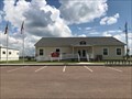
 view gallery view galleryW9.5 km |  Friendsville, Maryland Friendsville, Maryland
in City and Town Halls The Friendsville Town Hall is located on Chestnut Street in extreme Western Garrett County, Maryland posted by: outdoorboy34 location: Maryland date approved: 05/09/2014 last visited: never |
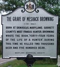 view gallery view gallerySW9.5 km | The Grave of Meshack Browning in Maryland Historical Markers Located in a Cemetary (of course!)along northbound Friendship road. Parking is tight. posted by: flyingmoose location: Maryland date approved: 09/17/2006 last visited: 02/01/2012 |
|