 view gallery view gallery SW10 km SW10 km
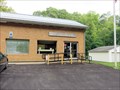
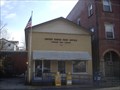
|   Pine Grove, WV. 26419 Pine Grove, WV. 26419
in U.S. Post Offices Pine Grove, WV Post Office posted by:  dukemartin dukemartin location: West Virginia date approved: 07/30/2012 last visited: never |
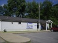
 view gallery view gallery NE10.6 km NE10.6 km
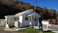
| Littleton WV 26581 Post Office in U.S. Post Offices Littleton WV 26581 Post Office posted by: dukemartin location: West Virginia date approved: 06/19/2015 last visited: never |
 view gallery view gallery S11.1 km S11.1 km
| Jacksonburg, WV. 26377 in U.S. Post Offices Jacksonburg WV, Post Office posted by: dukemartin location: West Virginia date approved: 07/30/2012 last visited: never |
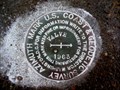
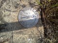 view gallery view gallery SE11.7 km SE11.7 km
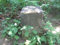
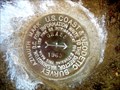
|  EVANS 2 1957 - Reset 1969 - Wetzel County, WV EVANS 2 1957 - Reset 1969 - Wetzel County, WV
in U.S. Benchmarks This benchmark station is located on what is known as Evans Knob. It is located about 9 miles west of Mannington, WV. posted by:  ellishagerman ellishagerman location: West Virginia date approved: 06/07/2012 last visited: never |
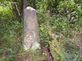 view gallery view galleryNE12.4 km |  Southwest Pennsylvania Corner Monument, 1883 Southwest Pennsylvania Corner Monument, 1883
in U.S. Historic Survey Stones and Monuments Terminus of the Mason and Dixon Line AND the Ellicott Line, separating West Virgina from Pennsylvania. Monument is somewhat weathered after 124 years in the woods. posted by: Algoma! location: Pennsylvania date approved: 08/27/2007 last visited: 03/04/2006 |
 view gallery view galleryNE12.6 km | USCGS PA-WV Meridian (45), 1883, Pennsylvania-West Virginia in U.S. Historic Survey Stones and Monuments USCGS PA-WV Meridian Stone (45), 1883, PA-WV, is a dressed sandstone shaft set by the 1883 - 1885 re-survey of Pennsylvania’s western boundary with West Virginia. posted by: seventhings location: Pennsylvania date approved: 08/13/2007 last visited: 08/25/2007 |
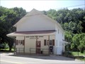
 view gallery view gallerySW13.2 km | Reader, WV. 26167 in U.S. Post Offices Reader, WV Post Office posted by: dukemartin location: West Virginia date approved: 08/03/2012 last visited: never |
 view gallery view galleryNE13.2 km |  Fish Creek Covered Bridge - Hundred WV Fish Creek Covered Bridge - Hundred WV
in Truss Bridges The Fish Creek Covered Bridge was built circa 1881 near Hundred, West Virginia. It is the last remaining covered bridge in Wetzel County and one of two remaining single kingpost truss bridges in West Virginia. posted by: nomadwillie location: West Virginia date approved: 12/18/2021 last visited: never |
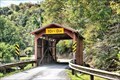 view gallery view galleryNE13.2 km |  Fish Creek Covered Bridge - Hundred WV Fish Creek Covered Bridge - Hundred WV
in U.S. National Register of Historic Places The Fish Creek Covered Bridge was built circa 1881 near Hundred, West Virginia. It is the last remaining covered bridge in Wetzel County and one of two remaining single kingpost truss bridges in West Virginia. posted by: nomadwillie location: West Virginia date approved: 12/18/2021 last visited: never |
 view gallery view galleryNE13.2 km |  Fish Creek Covered Bridge - Hundred WV Fish Creek Covered Bridge - Hundred WV
in Wikipedia Entries The Fish Creek Covered Bridge was built circa 1881 near Hundred, West Virginia. It is the last remaining covered bridge in Wetzel County and one of two remaining single kingpost truss bridges in West Virginia. posted by: nomadwillie location: West Virginia date approved: 12/18/2021 last visited: never |
 view gallery view galleryNE13.2 km |  Fish Creek Covered Bridge - Hundred WV Fish Creek Covered Bridge - Hundred WV
in Covered Bridges The Fish Creek Covered Bridge was built circa 1881 near Hundred, West Virginia. It is the last remaining covered bridge in Wetzel County and one of two remaining single kingpost truss bridges in West Virginia. posted by: nomadwillie location: West Virginia date approved: 12/18/2021 last visited: never |
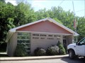
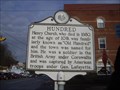 view gallery view galleryNE13.2 km |  Hundred Hundred
in West Virginia Historical Markers A sign telling how the town got its name. posted by: Paintedwarrior location: West Virginia date approved: 02/05/2013 last visited: 02/09/2013 |
 view gallery view galleryNE13.2 km | Hundred WV 26575 Post Office in U.S. Post Offices Hundred WV 26575 Post Office posted by: dukemartin location: West Virginia date approved: 01/31/2013 last visited: 06/08/2012 |
 view gallery view gallery N13.4 km N13.4 km
|  CX4750(VALVE AZ MK) - Marshall County WV CX4750(VALVE AZ MK) - Marshall County WV
in Azimuth Benchmarks This is the azimuth mark for USC&GS triangulation station VALVE, in Marshall County. posted by: shorbird location: West Virginia date approved: 11/19/2017 last visited: never |
 view gallery view galleryS14.3 km | Smithfield, WV. 26437 in U.S. Post Offices Smithfield WV, Post Office posted by: dukemartin location: West Virginia date approved: 07/30/2012 last visited: never |
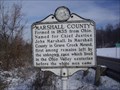
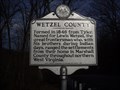 view gallery view gallery E15.1 km E15.1 km
| Marion County / Wetzel County in West Virginia Historical Markers A sign at the county line telling about the formation of the counties. posted by: Paintedwarrior location: West Virginia date approved: 02/05/2013 last visited: 02/09/2013 |
 view gallery view galleryNE17.7 km | CX4618(GRASS AZ MK) - Springhill Twp Greene County PA in Azimuth Benchmarks This is the azimuth mark for USC&GS triangulation station GRASS. The station is in West Virginia, and the azimuth mark is in Springhill Township, Greene County. posted by: shorbird location: Pennsylvania date approved: 11/25/2017 last visited: never |
 view gallery view galleryNE20.6 km | New Freeport PA 15352 Post Office in U.S. Post Offices New Freeport PA Post Office posted by: dukemartin location: Pennsylvania date approved: 10/26/2017 last visited: never |
 view gallery view galleryN21.6 km |  Welling Tunnel, Cameron, West Virginia Welling Tunnel, Cameron, West Virginia
in Abandoned Train Tunnels Built in 1852 on the Baltimore & Ohio railroad posted by: sherpes location: Pennsylvania date approved: 09/30/2008 last visited: never |
 view gallery view gallery NW22.2 km NW22.2 km
| Marshall County / Wetzel County in West Virginia Historical Markers A two sided sign telling where the counties were formed from and who they were named after. posted by: Paintedwarrior location: West Virginia date approved: 02/18/2014 last visited: 03/01/2014 |
 view gallery view galleryNW22.2 km | Mason-Dixon Line in West Virginia Historical Markers A sign telling about the famous line between free and slave states. posted by: Paintedwarrior location: West Virginia date approved: 02/19/2014 last visited: 03/01/2014 |
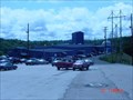 view gallery view galleryNW22.2 km |  ConsolEnergy McElroy Mine Blakes Ridge ConsolEnergy McElroy Mine Blakes Ridge
in Mines This is one of the ConsolEnergy Ohio Valley Operations Mines posted by: The Finding Irish 4 location: West Virginia date approved: 07/29/2008 last visited: 07/22/2008 |
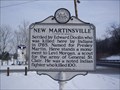 view gallery view gallery W22.5 km W22.5 km
| New Martinsville in West Virginia Historical Markers A sign telling who settled the area and who the town is named after. posted by: Paintedwarrior location: West Virginia date approved: 02/18/2014 last visited: 03/01/2014 |
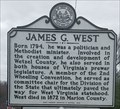 view gallery view galleryW22.5 km | James G. West in West Virginia Historical Markers James G. West involved in the creation and development of Wetzel county, WV posted by: dukemartin location: West Virginia date approved: 11/21/2023 last visited: never |
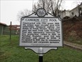 view gallery view galleryN22.7 km | Cameron City Pool in West Virginia Historical Markers Unique semi~circular pool with underwater lifeguard station. posted by: dukemartin location: West Virginia date approved: 04/01/2018 last visited: 04/01/2018 |
|