 view gallery view gallery N9.3 km N9.3 km
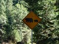
|   Bear crossing - HW 49 CA Bear crossing - HW 49 CA
in Uncommon Crossing Signs Remind the campers to clear the tables and use the bear proof vaults in the campgrounds. A bear leaves a bigger dent than a deer if your car should encounter one. posted by:  sbcamper sbcamper location: California date approved: 08/29/2016 last visited: never |
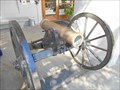
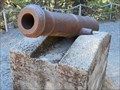 view gallery view galleryN9.8 km |  12 pound Civil War cannon - Downieville CA 12 pound Civil War cannon - Downieville CA
in Static Artillery Displays Hard to imagine the Civil War in California, but yes, folks took sides. Gold was important to the Union especially and units were formed to escort it and guard it. posted by: sbcamper location: California date approved: 07/10/2016 last visited: 10/10/2016 |
 view gallery view galleryN9.8 km |  Canon Point - 1959 - California Canon Point - 1959 - California
in U.S. Benchmarks Control monument near Downieville, California. posted by:  Volcanoguy Volcanoguy location: California date approved: 08/27/2017 last visited: 10/10/2016 |
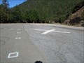 view gallery view gallery NW9.8 km NW9.8 km
|  North side of the Yuba River/ Downieville CA North side of the Yuba River/ Downieville CA
in Helicopter Landing Pads Actually south of town on the highway. Elevations between town and top of the mountain rdges my differ by 1,000 feet. posted by: sbcamper location: California date approved: 07/07/2016 last visited: never |
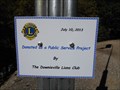 view gallery view galleryNW9.8 km |  Downievillle/ HW 49 Lions Heliport - Sierra County CA Downievillle/ HW 49 Lions Heliport - Sierra County CA
in Lions Clubs International Markers Nevada Co. is the nearest airport or hospital. Steep mountains, high elevation, winding two lane road make this a real public service project. posted by: sbcamper location: California date approved: 07/07/2016 last visited: never |
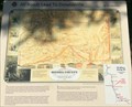
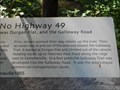
 view gallery view galleryN9.8 km |  Downieville - CA Hwy 49 Downieville - CA Hwy 49
in Signs of History History sign along CA Hwy 49. posted by: Volcanoguy location: California date approved: 08/27/2017 last visited: 10/10/2016 |
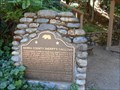 view gallery view galleryN9.8 km |  CHM No. 971 - Downieville CA CHM No. 971 - Downieville CA
in California Historical Markers Downieville was originally part of Yuba Co. Unwilling to wait for a distant government, the "gallows" became a symbol of the need for local government. posted by: sbcamper location: California date approved: 07/20/2016 last visited: 10/10/2016 |
 view gallery view galleryN9.8 km |  Sierra County Courthouse - Downieville CA Sierra County Courthouse - Downieville CA
in Courthouses One burned. This is the replaced two story building. posted by: sbcamper location: California date approved: 08/15/2016 last visited: 10/10/2016 |
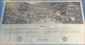
 view gallery view galleryN9.8 km | All Roads Lead To Downieville - CA Hwy 49 in Signs of History History sign along CA Hwy 49. posted by: Volcanoguy location: California date approved: 08/27/2017 last visited: 10/10/2016 |
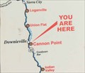 view gallery view galleryN9.8 km |  Hwy 49 - All Roads Lead To Downieville sign - California Hwy 49 - All Roads Lead To Downieville sign - California
in 'You Are Here' Maps ‘You Are Here’ map along Hwy 49. posted by: Volcanoguy location: California date approved: 08/27/2017 last visited: 10/10/2016 |
 view gallery view galleryN10 km |  Sierra County Sheriff’s Gallows — Downieville, CA Sierra County Sheriff’s Gallows — Downieville, CA
in U.S. National Register of Historic Places The Sierra County Sheriff’s Gallows was placed on the National Register of Historic Places on February 2, 1990. posted by: Volcanoguy location: California date approved: 08/28/2017 last visited: 10/10/2016 |
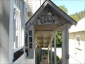
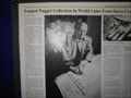 view gallery view galleryN10 km |  Mountain Messenger - Downieville CA Mountain Messenger - Downieville CA
in News Article Locations The Ruby Mine story. One hundred years after the gold rush, some folks still find gold. posted by: sbcamper location: California date approved: 07/21/2016 last visited: 10/10/2016 |
 view gallery view galleryN10 km |  Galloway Trail - Downieville CA Galloway Trail - Downieville CA
in Hiking and walking trailheads A multi use trail for hikers and mountain bikers. posted by: sbcamper location: California date approved: 07/30/2016 last visited: never |
 view gallery view galleryN10 km |  Sheriff's Office/Jail - Downieville CA Sheriff's Office/Jail - Downieville CA
in Police Stations Convenient to the courthouse. Downieville was once a part of Yuba County. It took a close vote to finally become an independent county. posted by: sbcamper location: California date approved: 07/12/2016 last visited: never |
 view gallery view galleryN10 km | Civil War cannon - Downieville CA in Static Artillery Displays A pair from different Massachusetts foundries. posted by: sbcamper location: California date approved: 07/07/2016 last visited: 10/10/2016 |
 view gallery view galleryN10.1 km |  Former IOOF Lodge - Downieville CA Former IOOF Lodge - Downieville CA
in Odd Fellow Lodges When the members closed their chapter, the building was sold to the Native Daughters of the Golden West. posted by: sbcamper location: California date approved: 07/10/2016 last visited: never |
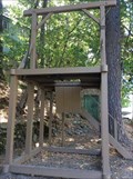
 view gallery view galleryN10.1 km |  Pelton wheel - Downieville CA Pelton wheel - Downieville CA
in Preserved Machines on Public Display Pelton wheels came in all sizes but required a large water source. The goal was to move and wash gold panning, tailings.
This could be lost among the vinca vines and snow. posted by: sbcamper location: California date approved: 07/05/2016 last visited: never |
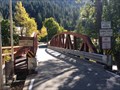
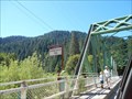 view gallery view galleryN10.1 km |  Old Durgan Bridge - Downieville CA Old Durgan Bridge - Downieville CA
in Truss Bridges a one lane bridge, built in 1938. Perhaps modified because there is now a separate pedestrian walk. posted by: sbcamper location: California date approved: 07/07/2016 last visited: 10/10/2016 |
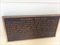
 view gallery view galleryN10.1 km |  Downieville Masonic Lodge (former) - Downieville CA Downieville Masonic Lodge (former) - Downieville CA
in Masonic Temples This building is being restored, and well done, as a community event center. Available for meetings, receptions, parties. posted by: sbcamper location: California date approved: 07/28/2016 last visited: never |
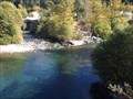 view gallery view galleryN10.1 km |  CONFLUENCE - Downie River and North Yuba River - California CONFLUENCE - Downie River and North Yuba River - California
in River Origins, Destinations and Confluences The Downie River is a major tributary to the North Yuba River. posted by: Volcanoguy location: California date approved: 08/28/2017 last visited: 10/10/2016 |
 view gallery view galleryN10.1 km | Durgan Bridge — Downieville, CA in U.S. National Register of Historic Places The Durgan Bridge was placed on the National Register of Historic Places on July 10, 2012. posted by: Volcanoguy location: California date approved: 08/30/2017 last visited: 10/10/2016 |
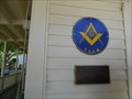
 view gallery view galleryN10.1 km |  Masonic Building — Downieville, CA Masonic Building — Downieville, CA
in E Clampus Vitus Historical Markers E Clampus Vitus plaque in Downieville, CA. posted by: Volcanoguy location: California date approved: 09/20/2017 last visited: 10/10/2016 |
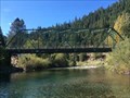
 view gallery view galleryN10.1 km | Jersey Bridge — Downieville, CA in U.S. National Register of Historic Places The Jersey Bridge was placed on the National Register of Historic Places on July 10, 2012. posted by: Volcanoguy location: California date approved: 08/30/2017 last visited: 10/10/2016 |
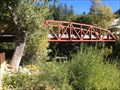 view gallery view galleryN10.1 km | Jersey Bridge - Downieville, CA in Truss Bridges A Parker truss bridge across the Downie River. posted by: Volcanoguy location: California date approved: 08/30/2017 last visited: 10/10/2016 |
 view gallery view galleryN10.1 km | In Memory of Juanita — Downieville, CA in E Clampus Vitus Historical Markers E Clampus Vitus plaque in Downieville, CA. posted by: Volcanoguy location: California date approved: 09/20/2017 last visited: 10/10/2016 |
|