 view gallery view gallery W24.9 km W24.9 km
|   Tie Fork Rest Area Tie Fork Rest Area
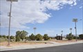
in Highway Rest Areas This Highway Rest Area is located on the north side of Horse Canyon Road just east of US Highway 6/191 about 25 miles southeast of Price, Utah. posted by:  brwhiz brwhiz location: Utah date approved: 05/15/2013 last visited: never |
 view gallery view galleryW24.9 km |  Woodside/Price River Ranches/D&RGW Narrow Gauge - Emery County, UT Woodside/Price River Ranches/D&RGW Narrow Gauge - Emery County, UT
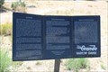
in Utah Historical Markers A three subject E Clampus Vitus Historical Marker can be found in the Horse Canyon Rest Area, on the east side of UT 6, just north of where Woodside once was. posted by: QuarrellaDeVil location: Utah date approved: 11/06/2018 last visited: 06/20/2021 |
 view gallery view galleryW24.9 km |  Woodside/Price River Ranches/D&RGW Narrow Gauge - Emery County, UT Woodside/Price River Ranches/D&RGW Narrow Gauge - Emery County, UT
in E Clampus Vitus Historical Markers A three subject E Clampus Vitus Historical Marker can be found in the Horse Canyon Rest Area, on the east side of UT 6, just north of where Woodside once was. posted by: QuarrellaDeVil location: Utah date approved: 10/26/2018 last visited: 06/20/2021 |
 view gallery view gallery NW28 km NW28 km
|  Sunnyside, Utah Sunnyside, Utah
in Wikipedia Entries Sunnyside is a small mining community of about 400 inhabitants situated in south-central Carbon County. posted by: brwhiz location: Utah date approved: 06/13/2011 last visited: never |
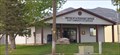
 view gallery view galleryNW28 km |  Sunnyside, Utah 84539 Sunnyside, Utah 84539
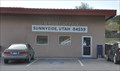
in U.S. Post Offices The Sunnyside Post Office serves about 170 households in its ZIP Code area from its location at 1 Market Street. posted by: brwhiz location: Utah date approved: 06/12/2011 last visited: never |
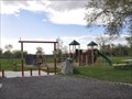
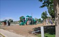
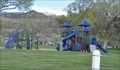 view gallery view galleryNW28.6 km |  Sunnyside Park Playground Sunnyside Park Playground
in Public Playgrounds This Public Playground is located in Sunnyside Park on the south side of Utah Highway 123 between Power Plant Road and Valley View Drive in Sunnyside, Utah. posted by: brwhiz location: Utah date approved: 05/13/2013 last visited: never |
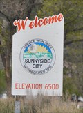 view gallery view galleryNW28.8 km |  Sunnyside City ~ Elevation 6500 Feet Sunnyside City ~ Elevation 6500 Feet
in Elevation Signs This Elevation Sign is located on the southeast side of Utah Highway 123 just east of the intersection with Denver Avenue, at the eastern city limits of Sunnyside, Utah. posted by: brwhiz location: Utah date approved: 05/13/2013 last visited: never |
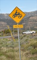 view gallery view galleryNW29.3 km |  ATV Crossing ATV Crossing
in Uncommon Crossing Signs This Unusual Crossing Sign is located on the south side of Utah Highway 123 at the eastern edge of East Carbon, Utah. posted by: brwhiz location: Utah date approved: 05/27/2013 last visited: never |
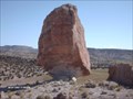
 view gallery view gallery SW29.6 km SW29.6 km
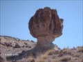
|  Green River Cut-off Balanced Rock Green River Cut-off Balanced Rock
in Nature's Balanced Rocks Green River Cut-off Balanced Rock posted by:  robbdogg120 robbdogg120 location: Utah date approved: 07/16/2007 last visited: 07/26/2008 |
 view gallery view galleryNW29.6 km |  East Carbon Museum East Carbon Museum
in History Museums This History Museum is located at 127 E Whitmore Drive in East Carbon, Utah. posted by: brwhiz location: Utah date approved: 05/13/2013 last visited: never |
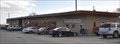
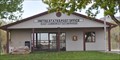
 view gallery view galleryNW29.8 km | East Carbon, Utah 84520 in U.S. Post Offices The East Carbon Post Office serves about 550 households in its ZIP Code area from its location at 109 Whitmore Drive. posted by: brwhiz location: Utah date approved: 06/12/2011 last visited: 03/26/2021 |
 view gallery view galleryNW29.8 km | East Carbon, Utah in Wikipedia Entries East Carbon is a small city of around 1500 inhabitants situated in south central Carbon County. posted by: brwhiz location: Utah date approved: 06/13/2011 last visited: 03/26/2021 |
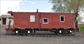 view gallery view galleryNW29.8 km |  Carbon County Railway Steel-Bodied Caboose #1 ~ East Carbon, Utah Carbon County Railway Steel-Bodied Caboose #1 ~ East Carbon, Utah
in Train Cabooses This Caboose is on display in the East Carbon City Park located at the intersection of Grassy Trail Drive and Whitmore Drive in East Carbon, Utah. posted by: brwhiz location: Utah date approved: 05/13/2013 last visited: 06/20/2021 |
 view gallery view galleryNW29.8 km | East Carbon Park Playground in Public Playgrounds This Public Playground is located in the park located at the intersection of Grassy Trail Drive and Whitmore Drive in East Carbon, Utah. posted by: brwhiz location: Utah date approved: 05/13/2013 last visited: 03/26/2021 |
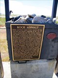 view gallery view galleryNW40.1 km | Rock Asphalt in E Clampus Vitus Historical Markers Marker locked just off Hwy 6 at junction with Hwy 123 southeast of Wellington, Utah. posted by:  BruceS BruceS location: Utah date approved: 06/28/2011 last visited: 09/06/2016 |
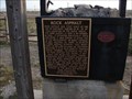 view gallery view galleryNW40.1 km | Rock Asphalt in Utah Historical Markers Rock asphalt was first mined at the top of Whitmore Canyon - 15 mi. NE of this location - in the early 1890's. posted by: JacobBarlow location: Utah date approved: 05/13/2007 last visited: 06/12/2020 |
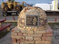 view gallery view galleryNW40.1 km | Settlement of East Carbon in Utah Historical Markers Just off Highway 6, Sunnyside Junction. posted by: JacobBarlow location: Utah date approved: 05/13/2007 last visited: 07/07/2015 |
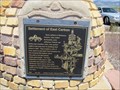 view gallery view galleryNW40.1 km |  Settlement of East Carbon - 272 Settlement of East Carbon - 272
in D.U.P. Historic Markers Marker off of Hwy 6 at junction of Hwy 123 southeast of Wellington, Utah. posted by: BruceS location: Utah date approved: 06/29/2011 last visited: 05/26/2011 |
 view gallery view galleryW40.7 km | Dripping Spring Balanced Rock in Nature's Balanced Rocks This Balanced Rock is near Sage Flat on the Price River posted by: robbdogg120 location: Utah date approved: 06/09/2007 last visited: 04/05/2008 |
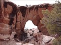 view gallery view gallerySW41.8 km |  Horse Heaven Arch Horse Heaven Arch
in Natural Arches A remote Arch posted by: robbdogg120 location: Utah date approved: 11/20/2006 last visited: 02/11/2006 |
 view gallery view gallery S43.1 km S43.1 km
| OK Anderson City Park Playground in Public Playgrounds This Public Playground is located in OK Anderson City Park at approximately 60 E 125 North in Green River, Utah. posted by: brwhiz location: Utah date approved: 05/13/2013 last visited: 06/04/2017 |
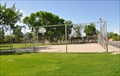 view gallery view galleryS43.1 km |  OK Anderson City Park Basketball Court OK Anderson City Park Basketball Court
in Outdoor Basketball Courts This Outdoor Basketball Court is located in OK Anderson City Park at approximately 55 N Solomon Street (100 East) in Green River, Utah. posted by: brwhiz location: Utah date approved: 05/13/2013 last visited: 06/04/2017 |
 view gallery view galleryS43.1 km |  The OK Anderson City Park - Green River UT The OK Anderson City Park - Green River UT
in Municipal Parks and Plazas OK Anderson City Park - Green River UT posted by: kJfishman location: Utah date approved: 10/24/2010 last visited: 06/04/2017 |
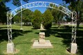
 view gallery view galleryS43.1 km |  OK Anderson City Park OK Anderson City Park
in Freestanding Arches OK Anderson City Park posted by: kJfishman location: Utah date approved: 10/21/2010 last visited: 06/04/2017 |
 view gallery view galleryS43.1 km |  Burt Loper - Green River UT Burt Loper - Green River UT
in Citizen Memorials Burt Loper pioneer of the sport of whitewater river-running posted by: kJfishman location: Utah date approved: 10/21/2010 last visited: 06/04/2017 |
|