 view gallery view gallery NW3.4 km NW3.4 km
|   Nicodemus Historic District - Nicodemus KS Nicodemus Historic District - Nicodemus KS
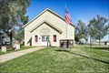
in U.S. National Register of Historic Places Nicodemus National Historic Site, located in Nicodemus, Kansas, United States, preserves, protects and interprets the only remaining western town established by African Americans during the Reconstruction Period following the American Civil War. posted by:  nomadwillie nomadwillie location: Kansas date approved: 07/16/2018 last visited: 05/10/2023 |
 view gallery view galleryNW3.5 km |  Nicodemus Nicodemus
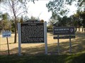
in Kansas Historical Markers The town of Nicodemus was a planned community devoted to Black settlement in the years after the U.S. Civil War. posted by:  Kansas Stasher Kansas Stasher location: Kansas date approved: 10/21/2006 last visited: 05/10/2023 |
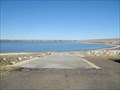
 view gallery view gallery E11.4 km E11.4 km
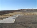
|  Old Marina Ramp - Webster State Park, KS Old Marina Ramp - Webster State Park, KS
in Boat Ramps Double lane ramp on north side of Webster Reservoir. posted by: Kansas Stasher location: Kansas date approved: 12/22/2006 last visited: never |
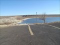 view gallery view galleryE14 km | Rock Point Ramp - Webster State Park, KS in Boat Ramps Double lane ramp on north side of Webster Reservoir. posted by: Kansas Stasher location: Kansas date approved: 12/22/2006 last visited: never |
 view gallery view galleryE14 km | Goose Flat Ramp - Webster State Park, KS in Boat Ramps Single lane ramp on south side of Webster Reservoir. posted by: Kansas Stasher location: Kansas date approved: 12/22/2006 last visited: never |
 view gallery view gallery W22.4 km W22.4 km
|  Hill City Cemetery - Hill City, KS Hill City Cemetery - Hill City, KS
in Worldwide Cemeteries Hill City Cemetery, final rest for about four thousand souls, is north of Hill City, Kansas. posted by: The Snowdog location: Kansas date approved: 01/09/2021 last visited: never |
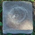
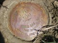 view gallery view galleryW22.4 km |  NGS F 365 RESET 2004, Nebraska NGS F 365 RESET 2004, Nebraska
in U.S. Benchmarks NGS F 365 RESET 2004 is a Vertical Control Mark located at the intersection of US Highway 283 and R Road about one mile north of Hill City, Graham County, KS. posted by: seventhings location: Kansas date approved: 05/31/2006 last visited: never |
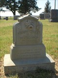
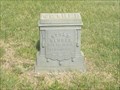 view gallery view galleryW22.5 km |  William J. Booth - Hill City Cemetery, Graham County, Kansas William J. Booth - Hill City Cemetery, Graham County, Kansas
in Zinc Headstones A zinc marker for William J. Boothe located in Hill City Cemetery, near Hill City, Graham Co., Kansas. posted by: fizzbomb location: Kansas date approved: 07/03/2008 last visited: never |
 view gallery view galleryW22.5 km | Justus Retherford - Hill City Cemetery, Graham Co., Kansas in Zinc Headstones A small zinc marker for Justus Harry Retherford located in Hill City Cemetery, near Hill City, Graham Co., Kansas. posted by: fizzbomb location: Kansas date approved: 07/03/2008 last visited: never |
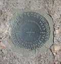
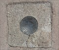 view gallery view galleryW22.5 km | HILL CITY (KG0316) - Hill City, KS in U.S. Benchmarks This U.S. Coast and Geodetic Survey Benchmark Disk is set in the concrete at a street corner - in Hill City, Kansas. posted by: The Snowdog location: Kansas date approved: 04/19/2024 last visited: never |
 view gallery view galleryW22.5 km |  Welcome to Hill City - Hill City, KS Welcome to Hill City - Hill City, KS
in Welcome Signs This "Welcome to Hill City" sign also proclaims the city as "Ringneck Country" - in Hill City, Kansas. posted by: The Snowdog location: Kansas date approved: 01/10/2021 last visited: never |
 view gallery view galleryW22.5 km |  Rotary International - Hill City, KS Rotary International - Hill City, KS
in Rotary International Markers The "Rotary International" symbol appears on this welcome sign in Hill City, Kansas. posted by: The Snowdog location: Kansas date approved: 01/09/2021 last visited: never |
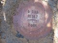 view gallery view galleryW22.7 km | NGS G 365 RESET 2004, Kansas in U.S. Benchmarks NGS G 365 RESET 2004, KS, is a Vertical Control Mark located near the intersection of US Highway 283 and T Road about three miles north of Hill City, Graham County, KS. posted by: seventhings location: Kansas date approved: 05/31/2006 last visited: never |
 view gallery view galleryW23.5 km | NGS X 11 RESET 2004, Kansas in U.S. Benchmarks NGS X 11 RESET 2004, KS, is a Vertical Control Mark located at the intersection of US Highway 283 and V Road about five miles north of Hill City, Graham County, KS. posted by: seventhings location: Kansas date approved: 05/31/2006 last visited: never |
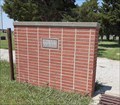
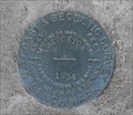 view gallery view galleryE27.7 km | KG0267 STOCKTON 1934 - Stockton, KS in U.S. Benchmarks This U.S. Coast and Geodetic Survey Benchmark Disk is on the left side of the north entrance to the Rooks County Courthouse in Stockton, Kansas. posted by: The Snowdog location: Kansas date approved: 01/11/2021 last visited: never |
 view gallery view galleryE27.7 km |  Rooks County Courthouse - Stockton, KS Rooks County Courthouse - Stockton, KS
in Courthouses This striking Classical Revival courthouse serves Rooks County; in Stockton, Kansas. posted by: The Snowdog location: Kansas date approved: 01/10/2021 last visited: never |
 view gallery view galleryE27.7 km |  Rooks County Courthouse - 1921 - Stockton, KS Rooks County Courthouse - 1921 - Stockton, KS
in Dated Architectural Structures Multifarious The plaques attached to the cornerstone of the Rooks County Courthouse give the date of construction as 1921 - in Stockton, Kansas. posted by: The Snowdog location: Kansas date approved: 01/08/2021 last visited: 06/09/2021 |
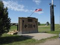
 view gallery view galleryE27.7 km |  Rooks County Veterans Memorial - Stockton, KS Rooks County Veterans Memorial - Stockton, KS
in Non-Specific Veteran Memorials The Rooks County Veterans Memorial is in the northeast corner of the County Courthouse Square in Stockton, Kansas. posted by: The Snowdog location: Kansas date approved: 01/09/2021 last visited: 05/03/2023 |
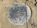
 view gallery view galleryE29 km | N 161 (KG0303) - Stockton, KS in U.S. Benchmarks This U.S. Coast and Geodetic Survey Benchmark Disk is set in a concrete culvert - in Stockton, Kansas. posted by: The Snowdog location: Kansas date approved: 04/19/2024 last visited: never |
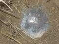
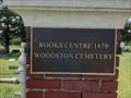 view gallery view galleryE39.9 km | Woodston Cemetery - Woodston, KS in Worldwide Cemeteries This small and well-tended cemetery is southwest of Woodston, Kansas. posted by: The Snowdog location: Kansas date approved: 01/10/2021 last visited: never |
 view gallery view galleryE39.9 km | Woodston Cemetery benchmark in U.S. Benchmarks This benchmark is next to the NE corner of the Woodston, KS cemetery. posted by: Rotareneg location: Kansas date approved: 09/30/2010 last visited: 08/06/2020 |
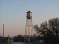 view gallery view galleryE42.8 km |  WOODSTON - Water Tank WOODSTON - Water Tank
in Water Towers Woodston Water Tank Woodston, Kansas posted by: GEO*Trailblazer 1 location: Kansas date approved: 03/18/2008 last visited: 03/19/2008 |
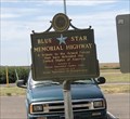 view gallery view gallery SW45.5 km SW45.5 km
|  I-70 WB Rest Area - WaKeeney, Kansas I-70 WB Rest Area - WaKeeney, Kansas
in Blue Star Memorial Highway Markers Blue Star Memorial Highway Marker located in rest area on West Bound IH-70 just East of WaKeeney, Kansas posted by: outwest63 location: Kansas date approved: 08/03/2019 last visited: 05/05/2021 |
 view gallery view galleryNW47 km | NGS M 364 RESET 1998, Kansas in U.S. Benchmarks NGS M 364 RESET 1998, KS, is a Vertical Control Mark located about 0.1 miles south of the intersection of US Highway 283 and Road T about eight miles south of Norton, Norton County, KS. posted by: seventhings location: Kansas date approved: 05/31/2006 last visited: never |
 view gallery view gallerySW47.2 km |  Iwo Jima Memorial, WaKeeney KS Iwo Jima Memorial, WaKeeney KS
in World War II Memorials / Monuments This WWII memorial for the Iwo Jima battle is located in WaKeeney, Kansas. posted by: Queens Blessing location: Kansas date approved: 05/31/2010 last visited: 05/01/2020 |
|