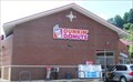
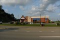
 view gallery view gallery NW1.1 km NW1.1 km
|   Dunkin Donuts - Bridgeport, WV Dunkin Donuts - Bridgeport, WV
in Dunkin Donuts' I-79 Exit 124 0.4 mile to east posted by:  vhasler vhasler location: West Virginia date approved: 11/24/2014 last visited: never |
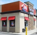 view gallery view galleryNW1.1 km |  DQ - Bridgeport, WV DQ - Bridgeport, WV
in Dairy Queen Restaurants I-79 Exit 124 posted by: vhasler location: West Virginia date approved: 06/21/2014 last visited: never |
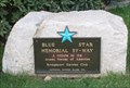
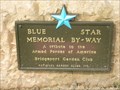 view gallery view gallery W2.6 km W2.6 km
|  I-79 (North Bound), Bridgeport, West Virginia I-79 (North Bound), Bridgeport, West Virginia
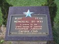
in Blue Star Memorial Highway Markers This Blue Star Memorial is located at a rest stop along I-79 (North Bound), near Bridgeport, West Virginia. posted by: deano1943 location: West Virginia date approved: 08/23/2007 last visited: 12/19/2019 |
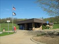
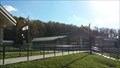 view gallery view galleryW2.6 km |  Meadowbrook Rest Area Northbound- I-79 Northbound - Bridgeport, WV Meadowbrook Rest Area Northbound- I-79 Northbound - Bridgeport, WV
in Highway Rest Areas This rest area is one of a pair located at Mile Marker 123 near Bridgeport, West Virginia posted by:  outdoorboy34 outdoorboy34 location: West Virginia date approved: 01/26/2017 last visited: 12/19/2019 |
 view gallery view galleryNW2.6 km |  IHOP- White Oaks Blvd - Bridgeville, West Virginia, USA IHOP- White Oaks Blvd - Bridgeville, West Virginia, USA
in IHOP Restaurants This IHOP is located at 185 White Oaks Blvd, Bridgeport, WV. Not far from exit 125 from I-79. posted by: ted28285 location: West Virginia date approved: 09/16/2022 last visited: 09/26/2022 |
 view gallery view galleryW2.9 km | I-79 South Mile 122 Rest Area - WV in Highway Rest Areas WVa southbound rest area for the wandering throng. posted by: vhasler location: West Virginia date approved: 05/04/2009 last visited: 01/29/2021 |
 view gallery view galleryW2.9 km | I-79 (South Bound), Bridgeport, West Virginia in Blue Star Memorial Highway Markers This Blue Star Memorial is located at a rest stop along I-79 (South Bound), near Bridgeport, West Virginia. posted by: deano1943 location: West Virginia date approved: 11/27/2007 last visited: 05/03/2014 |
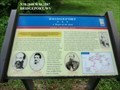
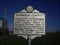 view gallery view gallery S4.3 km S4.3 km
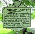
|  Harrison County / Taylor County Harrison County / Taylor County
in West Virginia Historical Markers A two sided sign telling when and where the counties were formed from. posted by: Paintedwarrior location: West Virginia date approved: 04/22/2013 last visited: 04/27/2013 |
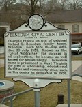 view gallery view gallery SW4.3 km SW4.3 km
| Benedum Civic Center in West Virginia Historical Markers Enlarged replica on site of original Michael L. Benedum family home posted by: two-bit Joe location: West Virginia date approved: 03/26/2011 last visited: 09/18/2011 |
 view gallery view gallerySW4.5 km |  Bridgeport Lamp Chimney Company Bowstring Concrete Arch Bridge Bridgeport Lamp Chimney Company Bowstring Concrete Arch Bridge
in U.S. National Register of Historic Places The Bridgeport Lamp Chimney Company Bowstring Concrete Arch Bridge is located between Machanic Street and the Baltimore & Ohio Railroad Tracks in Bridgeport, Harrison County, West Virginia. posted by: deano1943 location: West Virginia date approved: 08/19/2007 last visited: 05/15/2011 |
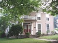 view gallery view gallerySW4.5 km | Johnson, Governor Joseph, House in U.S. National Register of Historic Places The Govenor Joseph Johnson House is located at 424 Oakdale Avenue in Bridgeport, Harrison County, West Virginia. posted by: deano1943 location: West Virginia date approved: 08/19/2007 last visited: 08/19/2007 |
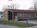
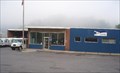 view gallery view gallerySW4.7 km |  Bridgeport, West Virginia - 26330 Bridgeport, West Virginia - 26330
in U.S. Post Offices Bridgeport Post Office is located in Bridgeport Borough, Harrison County, West Virginia. posted by: deano1943 location: West Virginia date approved: 08/19/2007 last visited: 05/15/2011 |
 view gallery view gallerySW4.7 km |  Bridgeport-A Target of the Raid - Bridgeport WV Bridgeport-A Target of the Raid - Bridgeport WV
in U.S. Civil War Sites On April 30, a detachment of the 1st Maryland Cavalry Battalion (CSA) under Capt. Frank A. Bond, who was later wounded and captured during the retreat from Gettysburg, attacked Bridgeport. posted by: Don.Morfe location: West Virginia date approved: 07/03/2023 last visited: 07/03/2023 |
 view gallery view gallerySW4.7 km |  Skirmish at Bridgeport - Bridgeport WV Skirmish at Bridgeport - Bridgeport WV
in Battlefields The Confederates drove through to Bridgeport and captured 47 Federal soldiers with their arms and a few horses, then burned a railroad bridge and tore up track. A boxcar full of government carpenters’ tools was also burned. posted by: Don.Morfe location: West Virginia date approved: 11/21/2020 last visited: 10/16/2021 |
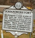 view gallery view gallerySW4.8 km | John Powers' Fort in West Virginia Historical Markers John Powers, 1771 posted by: two-bit Joe location: West Virginia date approved: 10/12/2006 last visited: 04/18/2013 |
 view gallery view gallerySW4.8 km | US 50 - Bridgeport, West Virginia in Blue Star Memorial Highway Markers This Blue Star Memorial is located along West Main Street US Rt. 50, in Bridgeport, Harrison County, West Virginia. posted by: deano1943 location: West Virginia date approved: 08/19/2007 last visited: 08/19/2007 |
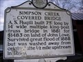 view gallery view galleryW5 km | Simpson Creek Covered Bridge in West Virginia Historical Markers A nice covered bridge that is home to a geocache! posted by: renruts location: West Virginia date approved: 01/02/2007 last visited: 10/02/2015 |
 view gallery view galleryW5 km | Simpson Creek Covered Bridge in U.S. National Register of Historic Places Simpson Creek Covered Bridge is located near Bridgeport, in Eastern Township, Harrison County, West Virginia. posted by: deano1943 location: West Virginia date approved: 08/19/2007 last visited: 03/14/2014 |
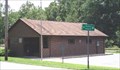
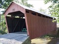 view gallery view galleryW5 km |  Simpson Creek Covered Bridge Simpson Creek Covered Bridge
in Covered Bridges Simpson Creek Covered Bridge is located near Bridgeport, in Eastern Township, Harrison County, West Virginia.
posted by: deano1943 location: West Virginia date approved: 08/19/2007 last visited: 03/14/2014 |
 view gallery view gallerySW5.8 km |  McDonalds - Bridgeport - West Virginia McDonalds - Bridgeport - West Virginia
in McDonald's Restaurants This McDonalds is located in Bridgeport, West Virginia. posted by: deano1943 location: West Virginia date approved: 08/18/2007 last visited: 08/18/2007 |
 view gallery view galleryNW6.8 km | Saltwell in West Virginia Historical Markers Tells us about the first deep well drilled in the United States. posted by: Paintedwarrior location: West Virginia date approved: 07/13/2012 last visited: 07/15/2012 |
 view gallery view gallerySW7.1 km | Clarksburg, West Virginia - 26301 in U.S. Post Offices Clarksburg Post Office is located in Clarksburg Borough, Harrison County, West Virginia. posted by: deano1943 location: West Virginia date approved: 08/19/2007 last visited: 05/15/2011 |
 view gallery view gallery N7.1 km N7.1 km
| Harrison County / Taylor County in West Virginia Historical Markers A sign at the county line telling about the formation of Harrison and Taylor counties. posted by: Paintedwarrior location: West Virginia date approved: 02/05/2013 last visited: 02/09/2013 |
 view gallery view gallery SE7.4 km SE7.4 km
| Rosemont, West Virginia - 26424 in U.S. Post Offices Rosemont Post Office is located in Rosemont Borough, Taylor County, West Virginia. posted by: deano1943 location: West Virginia date approved: 08/18/2007 last visited: 01/22/2012 |
 view gallery view galleryNW8.7 km | Meadowbrook, West Virginia - 26404 in U.S. Post Offices Meadowbrook Post Office is located in the small community of Meadowbrook, Harrison County, West Virginia. posted by: deano1943 location: West Virginia date approved: 11/28/2007 last visited: 09/24/2011 |
|