 view gallery view gallery SW1.6 km SW1.6 km
|   Beallsville Squabble at the cemetery: Whose flag flies today? - Beallsville MD Beallsville Squabble at the cemetery: Whose flag flies today? - Beallsville MD
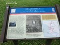
in Civil War Discovery Trail Sites On September 9, 1862, the running engagement between Illinois, Indiana, and Virginia cavalry units that began the day before in Poolesville continued in Beallsville when two Federal regiments forced the single regiment of Virginia cavalrymen posted here to flee to Barnesville. posted by:  Don.Morfe Don.Morfe location: Maryland date approved: 03/22/2020 last visited: 10/08/2021 |
 view gallery view gallerySW1.6 km | Beallsville Squabble at the cemetery: Whose flag flies today? - Beallsville MD in U.S. Civil War Sites On September 9, 1862, the running engagement between Illinois, Indiana, and Virginia cavalry units that began the day before in Poolesville continued in Beallsville. posted by: Don.Morfe location: Maryland date approved: 03/27/2023 last visited: 04/02/2023 |
 view gallery view gallerySW1.6 km |  You Are Here Map - Beallsville Squabble at the cemetery: Whose flag flies today? - Beallsville MD You Are Here Map - Beallsville Squabble at the cemetery: Whose flag flies today? - Beallsville MD
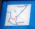
in 'You Are Here' Maps You Are Here map shows that you are at the intersection of Beallsville Road (Maryland Route 109) and Darnestown Road (Maryland Route 28) in Beallsville MD posted by: Don.Morfe location: Maine date approved: 03/27/2023 last visited: 04/02/2023 |
 view gallery view gallery W2.3 km W2.3 km
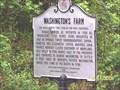
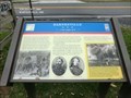
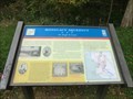
|  WASHINGTON'S FARM WASHINGTON'S FARM
in Maryland Historical Markers WASHINGTON'S FARM posted by:  mrfixitman mrfixitman location: Maryland date approved: 05/14/2006 last visited: 04/15/2012 |
 view gallery view gallery NE3.9 km NE3.9 km
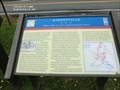
| Barnesville “Before night our town changed hands five times!” - Barnesville MD in Civil War Discovery Trail Sites On the evening of September 5, 1862, Gen. Wade Hampton’s and Gen. Fitzhugh Lee’s Confederate cavalry brigades bivouacked around Barnesville. posted by: Don.Morfe location: Maryland date approved: 03/22/2020 last visited: 10/08/2021 |
 view gallery view galleryNE3.9 km | Barnesville “... a bad night of it...” - Barnesville, MD in Civil War Discovery Trail Sites The advance of Union Gen. John F. Reynolds’ I Corps began slogging through Barnesville on the morning of Friday, June 26, 1863, having crossed the Potomac River the afternoon before and camped west of town. posted by: Don.Morfe location: Maryland date approved: 03/22/2020 last visited: 10/08/2021 |
 view gallery view galleryNE3.9 km | Barnesville “… a bad night of it…” - Barnesville MD in U.S. Civil War Sites The advance of Union Gen. John F. Reynolds’ I Corps began slogging through Barnesville on the morning of Friday, June 26, 1863, having crossed the Potomac River the afternoon before and camped west of town. posted by: Don.Morfe location: Maryland date approved: 03/27/2023 last visited: 04/02/2023 |
 view gallery view galleryNE3.9 km | You Are Here Map - Barnesville “… a bad night of it…” - Barnesville MD in 'You Are Here' Maps The You Are Here Map shows that you are at the intersection of Barnesville Road and West Harris Road in Barnesville MD in the parking lot of the St. Mary’s Church. posted by: Don.Morfe location: Maryland date approved: 03/27/2023 last visited: 04/02/2023 |
 view gallery view gallery NW4.2 km NW4.2 km
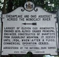
| Chesapeake and Ohio Aqueduct Across the Monocacy River in Maryland Historical Markers Located at the intersection of route 28 and the Mouth of Monocacy Rd. This marker points down the road to the site of the largest of the 11 aqueducts along the C&O Canal. posted by: flyingmoose location: Maryland date approved: 09/01/2006 last visited: 06/28/2022 |
 view gallery view gallery S5.1 km S5.1 km
| Poolesville-Warm Reception - Poolesville, MD in Civil War Discovery Trail Sites Located at the intersection of the two main roads, mid-19th century Poolesville was Montgomery County’s second-largest town. posted by: Don.Morfe location: Maryland date approved: 03/20/2020 last visited: 10/08/2021 |
 view gallery view galleryS5.1 km | Poolesville-Warm Reception - Poolesville MD in U.S. Civil War Sites Located at the intersection of the two main roads, mid-19th century Poolesville was Montgomery County’s second-largest town. Its residents had decidedly secessionist tendencies and many sons fighting for the South. posted by: Don.Morfe location: Maryland date approved: 03/27/2023 last visited: 04/02/2023 |
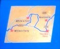 view gallery view galleryS5.1 km | You Are Here - Poolesville - Poolesville MD in 'You Are Here' Maps The You Are Here Map shows that you are in Poolesville MD at the intersection of Fisher Avenue / Whites Ferry Road (Maryland Route 107) and Elgin Road / Beallsville Road (Route 109). posted by: Don.Morfe location: Maryland date approved: 03/27/2023 last visited: 04/02/2023 |
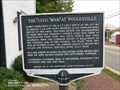
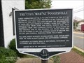 view gallery view galleryS5.1 km |  The Civil War at Poolesville - Poolesville MD The Civil War at Poolesville - Poolesville MD
in Signs of History Famed commander, Lt. Col. E.V. (“Lige”) White, of the 35th BN Va. Cavalry C.S.A., and many members of his command were natives of this area. posted by: Don.Morfe location: Maryland date approved: 03/18/2020 last visited: 09/27/2021 |
 view gallery view galleryS5.1 km |  The Civil War at Poolesville - Poolesville MD The Civil War at Poolesville - Poolesville MD
in Battlefields Maj. Gen. Joseph Hooker’s Headquarters were established here on June 26, 1863, during the Gettysburg Campaign. Skirmishes occurred here in September, November and December 1862 and July 1864. posted by: Don.Morfe location: Maryland date approved: 11/28/2021 last visited: 11/28/2021 |
 view gallery view galleryS5.1 km | The Civil War at Poolesville - Poolesville MD in American Civil War Monuments and Memorials Maj. Gen. Joseph Hooker’s Headquarters were established here on June 26, 1863, during the Gettysburg Campaign. Skirmishes occurred here in September, November and December 1862 and July 1864. posted by: Don.Morfe location: Maryland date approved: 06/26/2023 last visited: 05/21/2020 |
 view gallery view galleryS5.1 km |  1785 House-Poolesville Historic District – Poolesville MD 1785 House-Poolesville Historic District – Poolesville MD
in NRHP Historic Districts - Contributing Buildings The boundaries of the Poolesville Historic District encompass an interesting collection of 19th and early-20th century architecture in Montgomery County. Included in this district is the 1785 House at 20000 Fisher Ave. posted by: Don.Morfe location: Maryland date approved: 11/28/2021 last visited: 04/02/2023 |
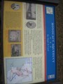
 view gallery view galleryNW5.1 km |  Welcome to Frederick Co. Welcome to Frederick Co.
in Your Name Here This sign has my middle name, Frederick. posted by: pseudoprime location: Maryland date approved: 11/09/2008 last visited: 04/15/2012 |
 view gallery view galleryNW5.5 km | Monocacy Aqueduct in Civil War Discovery Trail Sites Located along the C & O canal this is a well preserved site for all historians. posted by: flyingmoose location: Maryland date approved: 04/03/2008 last visited: 06/28/2022 |
 view gallery view galleryNW5.5 km | Monocacy Aqueduct Too Tough To Crack - Dickerson MD in U.S. Civil War Sites Confederate Gen. D. H. Hill’s division crossed the Potomac at Point of Rocks on September 4, 1862, and marched south to clear Union forces from the area. His men breached and drained the Chesapeake and Ohio Canal at several places. posted by: Don.Morfe location: Maryland date approved: 03/25/2023 last visited: 03/26/2023 |
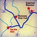 view gallery view galleryNW5.5 km | You Are Here Map - Monocacy Aqueduct Too Tough To Crack - Dickerson MD in 'You Are Here' Maps The You Are Here Map shows that you are near the Monocacy River Ford. posted by: Don.Morfe location: Maryland date approved: 03/25/2023 last visited: 03/26/2023 |
 view gallery view galleryNW5.6 km |  Chesapeake and Ohio Canal National Historical Park- Monocacy Aqueduct - Dickerson MD Chesapeake and Ohio Canal National Historical Park- Monocacy Aqueduct - Dickerson MD
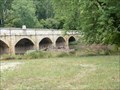
in Satellite Imagery Oddities The Monocacy Aqueduct — or C&O Canal Aqueduct No. 2 — is the largest aqueduct on the Chesapeake and Ohio Canal, crossing the Monocacy River just before it empties into the Potomac River in Frederick County, Maryland, USA. posted by: Don.Morfe location: Maryland date approved: 07/30/2022 last visited: 03/26/2023 |
 view gallery view galleryNW5.6 km | ") Chesapeake and Ohio Canal National Historical Park- Monocacy Aqueduct - Dickerson MD Chesapeake and Ohio Canal National Historical Park- Monocacy Aqueduct - Dickerson MD
in National Parks (U.S.) The Monocacy Aqueduct — or C&O Canal Aqueduct No. 2 — is the largest aqueduct on the Chesapeake and Ohio Canal, crossing the Monocacy River just before it empties into the Potomac River in Frederick County, Maryland, USA. posted by: Don.Morfe location: Maryland date approved: 08/02/2022 last visited: 03/26/2023 |
 view gallery view galleryNW5.6 km |  Chesapeake and Ohio Canal National Historical Park- Monocacy Aqueduct - Dickerson MD Chesapeake and Ohio Canal National Historical Park- Monocacy Aqueduct - Dickerson MD
in National Parks of the World The Monocacy Aqueduct — or C&O Canal Aqueduct No. 2 — is the largest aqueduct on the Chesapeake and Ohio Canal, crossing the Monocacy River just before it empties into the Potomac River in Frederick County, Maryland, USA. posted by: Don.Morfe location: Maryland date approved: 08/02/2022 last visited: 03/26/2023 |
 view gallery view galleryNW5.6 km |  Chesapeake and Ohio Canal National Historical Park- Monocacy Aqueduct - Dickerson MD Chesapeake and Ohio Canal National Historical Park- Monocacy Aqueduct - Dickerson MD
in Official Local Tourism Attractions The Monocacy Aqueduct — or C&O Canal Aqueduct No. 2 — is the largest aqueduct on the Chesapeake and Ohio Canal, crossing the Monocacy River just before it empties into the Potomac River in Frederick County, Maryland, USA. posted by: Don.Morfe location: Maryland date approved: 07/31/2022 last visited: 03/26/2023 |
 view gallery view galleryNW5.6 km |  Monocacy Aqueduct - Dickerson MD Monocacy Aqueduct - Dickerson MD
in Wikipedia Entries The Monocacy Aqueduct — or C&O Canal Aqueduct No. 2 — is the largest aqueduct on the Chesapeake and Ohio Canal, crossing the Monocacy River just before it empties into the Potomac River in Frederick County. posted by: Don.Morfe location: Maryland date approved: 06/28/2022 last visited: 03/26/2023 |
|