 view gallery view gallery SE9.3 km SE9.3 km
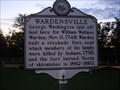
|   Wardensville Wardensville
in West Virginia Historical Markers A short history of events that occurred near Wardensville. posted by:  Paintedwarrior Paintedwarrior location: West Virginia date approved: 08/26/2013 last visited: 08/30/2013 |
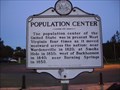 view gallery view gallerySE9.3 km | Population Center in West Virginia Historical Markers A sign listing the location of the population center of the United States as it moved westward across West Virginia. posted by: Paintedwarrior location: West Virginia date approved: 08/26/2013 last visited: 08/30/2013 |
 view gallery view gallery SW10.3 km SW10.3 km
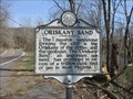
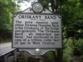
| Oriskany Sand in West Virginia Historical Markers A sign telling us about the massive sandstone formations. posted by: dukemartin location: West Virginia date approved: 04/16/2018 last visited: 04/16/2018 |
 view gallery view gallery E11.9 km E11.9 km
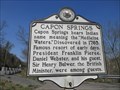
| Capon Springs in West Virginia Historical Markers Capon Spring bears the Indian name meaning the "Medicine Waters". posted by: dukemartin location: West Virginia date approved: 04/16/2018 last visited: 04/16/2018 |
 view gallery view galleryE11.9 km | Capon Lake Whipple Truss Bridge in West Virginia Historical Markers West Virginia's oldest extant metal truss bridge. posted by: dukemartin location: West Virginia date approved: 04/16/2018 last visited: 04/16/2018 |
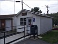
 view gallery view gallerySW12.7 km |  Baker, WV 26801 Baker, WV 26801
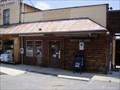
in U.S. Post Offices Baker WV 26801 Post Office posted by: dukemartin location: West Virginia date approved: 05/31/2012 last visited: 11/03/2019 |
 view gallery view gallery NE17.9 km NE17.9 km
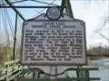
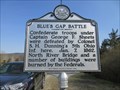
| Blue's Gap Battle in West Virginia Historical Markers A sign giving a brief history of the civil war battle fought here. posted by: dukemartin location: West Virginia date approved: 04/16/2018 last visited: 04/16/2018 |
 view gallery view galleryNE17.9 km | Oriskany Sand in West Virginia Historical Markers A sign telling the amount of gas produced. posted by: Paintedwarrior location: West Virginia date approved: 08/26/2013 last visited: 08/30/2013 |
 view gallery view galleryE18.2 km |  Eagle Rock. Virginia, United States. Eagle Rock. Virginia, United States.
in Scenic Overlooks Rewarding view from either a short or long walk, you choose. posted by: flyingmoose location: Virginia date approved: 07/18/2021 last visited: never |
 view gallery view gallery N18.8 km N18.8 km
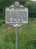
| Ice Mountain in West Virginia Historical Markers Intersection of Route 50 and 29, parking is nearby as well as a nice asortment of flowers surrounding the marker.
Please see marker webpage for information about Ice Mountain and the available tours. posted by: flyingmoose location: West Virginia date approved: 07/24/2006 last visited: 01/18/2012 |
 view gallery view galleryN19.6 km | Shanks, West Virginia - 26761 in U.S. Post Offices Shanks Post Office is located along US Route 50 in Shanks, West Virginia. posted by: deano1943 location: West Virginia date approved: 07/09/2010 last visited: 01/18/2012 |
 view gallery view gallery S21.9 km S21.9 km
|  Big Schloss, Wolf Gap Rec. Area ~ Nr. Edinburg, VA Big Schloss, Wolf Gap Rec. Area ~ Nr. Edinburg, VA
in Mountain Summits Big Schloss (German for Castle) is another treasure in the George Washington National Forest. A relatively easy hike at only 4.4 miles and 1,000 vertical feet from the parking lot at Wolf Gap. posted by:  garmin_geek garmin_geek location: Virginia date approved: 01/28/2009 last visited: 11/26/2023 |
 view gallery view galleryN22.2 km |  Koolwink Motel - Romney, West Virginia Koolwink Motel - Romney, West Virginia
in Recommended Accommodation Located on the East end of Romney. posted by: flyingmoose location: West Virginia date approved: 10/26/2020 last visited: never |
 view gallery view galleryN22.2 km |  Koolwink Motel - Romney, West Virginia Koolwink Motel - Romney, West Virginia
in Antique Hotels West bound side of route 50 in Romney. posted by: flyingmoose location: West Virginia date approved: 05/13/2021 last visited: never |
 view gallery view gallery NW22.9 km NW22.9 km
|  Captain George W. Stump "Stump's Battery" - Romney WV Captain George W. Stump "Stump's Battery" - Romney WV
in Civil War Discovery Trail Sites This is Hickory Grove, the home of Adam and Mary Stump and their son Capt. George W. Stump, who led a company of the 18th Virginia Cavalry during the war. posted by: Don.Morfe location: West Virginia date approved: 08/31/2020 last visited: 10/04/2021 |
 view gallery view galleryNW22.9 km | Captain George W. Stump "Stump's Battery" - Romney WV in U.S. Civil War Sites Marker is in Romney, West Virginia, in Hampshire County on South Branch River Road (County Route 8), Romney WV 26757 posted by: Don.Morfe location: West Virginia date approved: 07/13/2023 last visited: 07/13/2023 |
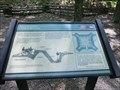 view gallery view galleryNW23.2 km | Interior of the Central Redoubt - Mechanicsburg WV in U.S. Civil War Sites The central redoubt consists of a square earthen platform or rampart, and earthen walls, or parapets. Cuts in the parapets, or embrasures, provided openings through which cannons could fire. posted by: Don.Morfe location: West Virginia date approved: 08/30/2020 last visited: 10/04/2021 |
 view gallery view galleryNW23.2 km |  Interior of the Central Redoubt - Mechanicsburg WV Interior of the Central Redoubt - Mechanicsburg WV
in Battlefields The central redoubt consists of a square earthen platform or rampart, and earthen walls, or parapets. Cuts in the parapets, or embrasures, provided openings through which cannons could fire. posted by: Don.Morfe location: West Virginia date approved: 09/01/2023 last visited: 09/01/2023 |
 view gallery view galleryNW23.2 km |  Interior of the Central Redoubt - Mechanicsburg WV Interior of the Central Redoubt - Mechanicsburg WV
in Signs of History The central redoubt consists of a square earthen platform or rampart, and earthen walls, or parapets. Cuts in the parapets, or embrasures, provided openings through which cannons could fire. posted by: Don.Morfe location: West Virginia date approved: 09/01/2023 last visited: 09/02/2023 |
 view gallery view galleryNW23.2 km | The Central Redoubt - Mechanicsburg WV in Battlefields The central redoubt house the fort's artillery. The square structure is approximately forty feet wide inside. The fort's entrance was located on the north, its least vulnerable side. posted by: Don.Morfe location: West Virginia date approved: 08/30/2023 last visited: 08/31/2023 |
 view gallery view galleryNW23.2 km | The Central Redoubt - Mechanicsburg WV in Signs of History The central redoubt house the fort's artillery. The square structure is approximately forty feet wide inside. The fort's entrance was located on the north, its least vulnerable side. posted by: Don.Morfe location: West Virginia date approved: 08/30/2023 last visited: 08/31/2023 |
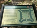 view gallery view galleryNW23.2 km | The Central Redoubt - Mechanicsburg WV in U.S. Civil War Sites The central redoubt house the fort's artillery. The square structure is approximately forty feet wide inside. The fort's entrance was located on the north, its least vulnerable side. posted by: Don.Morfe location: West Virginia date approved: 08/30/2020 last visited: 10/04/2021 |
 view gallery view galleryNW23.2 km | Control of the Mechanicsburg Gap - Mechanicsburg WV in U.S. Civil War Sites Federal Battery E, 1st (West) Virginia Volunteer Artillery was assigned to the command at Fort Mill Ridge. The Battery was armed with six 3-inch rifled cannons. It is believed that two of these cannons were positioned in the central redoubt. posted by: Don.Morfe location: West Virginia date approved: 08/30/2020 last visited: 10/04/2021 |
 view gallery view galleryNW23.2 km | Control of the Mechanicsburg Gap - Mechanicsburg WV in Battlefields Federal Battery E, 1st (West) Virginia Volunteer Artillery was assigned to the command at Fort Mill Ridge. The Battery was armed with six 3-inch rifled cannons. It is believed that two of these cannons were positioned in the central redoubt. posted by: Don.Morfe location: West Virginia date approved: 09/01/2023 last visited: 09/01/2023 |
 view gallery view galleryNW23.2 km | Control of the Mechanicsburg Gap - Mechanicsburg WV in Signs of History Federal Battery E, 1st (West) Virginia Volunteer Artillery was assigned to the command at Fort Mill Ridge. The Battery was armed with six 3-inch rifled cannons. It is believed that two of these cannons were positioned in the central redoubt. posted by: Don.Morfe location: West Virginia date approved: 09/01/2023 last visited: 09/02/2023 |
|