 view gallery view gallery E0.3 km E0.3 km
|   Belleville Belleville
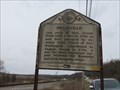
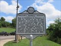
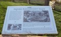
in West Virginia Historical Markers Belleville, an important outpost fort between the Kanawha and Little Kanawha rivers. posted by:  dukemartin dukemartin location: West Virginia date approved: 03/03/2020 last visited: never |
 view gallery view gallery N8.9 km N8.9 km
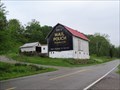
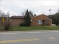
|  Mail Pouch barn - MPB 35-05-07 Mail Pouch barn - MPB 35-05-07
in Barns Mail Pouch barn in Athens County, OH posted by:  Wallyum Wallyum location: Ohio date approved: 04/15/2021 last visited: never |
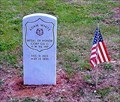 view gallery view galleryE9.2 km |  Adam White-Wadeville, WV Adam White-Wadeville, WV
in Medal Of Honor Resting Places Civil War Medal of Honor Recipient for action at Hatchers Run, VA on April 2, 1865. He is buried in Wadeville Cemetery, Wadeville, WV. posted by: Don.Morfe location: West Virginia date approved: 08/19/2019 last visited: 12/05/2021 |
 view gallery view gallery W10.3 km W10.3 km
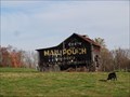
| Mail Pouch barn - MPB 35-53-03 in Barns Mail Pouch barn in Meigs County, OH posted by: Wallyum location: Ohio date approved: 04/13/2021 last visited: never |
 view gallery view gallery NW10.8 km NW10.8 km
|  Tuppers Plains, OH 45783 Tuppers Plains, OH 45783
in U.S. Post Offices This is the post office for the small town of Tuppers Plains, Ohio. posted by: silverquill location: Ohio date approved: 11/18/2007 last visited: never |
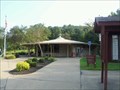
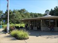
 view gallery view galleryN12.6 km |  Rest Area #10-37 - US Route 50 - Coolville, OH Rest Area #10-37 - US Route 50 - Coolville, OH
in Highway Rest Areas This rest Area is located on US Route 50 near Coolville, in Athens County, OH posted by: outdoorboy34 location: Ohio date approved: 01/23/2017 last visited: 01/29/2021 |
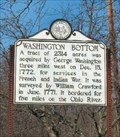 view gallery view galleryN13.8 km | Washington Bottom in West Virginia Historical Markers Washington, WV posted by: two-bit Joe location: West Virginia date approved: 02/14/2007 last visited: 02/28/2020 |
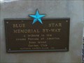 view gallery view galleryE16.1 km |  I-77 Southbound - Big Tygart, WV I-77 Southbound - Big Tygart, WV
in Blue Star Memorial Highway Markers This Blue Star Memorial Highway Marker is located at a rest area on I-77 Southbound. posted by: Hawaiian Ninja location: West Virginia date approved: 12/03/2010 last visited: 08/12/2011 |
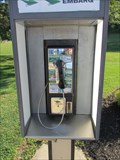 view gallery view galleryE16.1 km |  Payphone I-77 South Bound - Mineral Wells, WV Payphone I-77 South Bound - Mineral Wells, WV
in Payphones Payphone in a rest area posted by: uccacher location: West Virginia date approved: 08/22/2011 last visited: never |
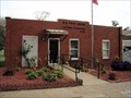
 view gallery view galleryN16.3 km | Washington West Virginia 26181 Post Office in U.S. Post Offices Washington, West Virginia Post Office posted by: dukemartin location: West Virginia date approved: 01/03/2017 last visited: never |
 view gallery view galleryE16.3 km | Mineral Wells Rest Area NB - I-77 Northbound - Mineral Wells, WV in Highway Rest Areas This rest Area is one of a pair located on Interstate 77 near Mile 166 in Mineral Wells, West Virginia. This one in particular is located in the northbound direction of travel. posted by: outdoorboy34 location: West Virginia date approved: 01/26/2017 last visited: 01/29/2021 |
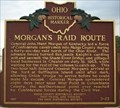 view gallery view galleryW16.6 km |  Morgan's Raid Route / Chester Village Commons ( 5 - 53 ) Morgan's Raid Route / Chester Village Commons ( 5 - 53 )
in Ohio Historical Markers On State Route 248 in scenic downtown Chester. posted by: boatchick location: Ohio date approved: 10/19/2008 last visited: 07/22/2012 |
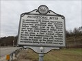 view gallery view gallery NE17.5 km NE17.5 km
| Prehistoric Sites in West Virginia Historical Markers Tells of prehistoric sites located on Blennerhassett Island. posted by: dukemartin location: West Virginia date approved: 01/03/2017 last visited: 01/04/2017 |
 view gallery view galleryE17.9 km | I-77 Mile Marker 166 - Mineral Sprints, WV in Highway Rest Areas Rest area accessible when heading southbound on I-77 posted by: uccacher location: West Virginia date approved: 08/24/2011 last visited: 01/29/2021 |
 view gallery view galleryW18 km | Mail Pouch barn - MPB 35-53-01 in Barns Mail Pouch barn in Meigs County, OH posted by: Wallyum location: Ohio date approved: 04/13/2021 last visited: never |
 view gallery view gallery S18.8 km S18.8 km
| Ravenswood WV 26164 Post Office in U.S. Post Offices Ravenswood WV 26164 Post Office posted by: dukemartin location: West Virginia date approved: 08/22/2016 last visited: never |
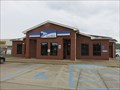
 view gallery view galleryNE19.2 km |  Cracker Barrel Restaurant #126, Mineral Wells, West Virginia Cracker Barrel Restaurant #126, Mineral Wells, West Virginia
in Cracker Barrel Restaurants This Cracker Barrel Restaurant is located at I-77 Exit 170 and SR. 14, in Mineral Wells, West Virginia. posted by: deano1943 location: West Virginia date approved: 07/08/2010 last visited: 11/13/2011 |
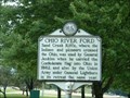 view gallery view galleryS20.3 km | Ohio River Ford/Ravenswood in West Virginia Historical Markers Where the Indians and pioneers crossed the Ohio.
These lands were surveyed, 1771, for George Washington posted by: two-bit Joe location: West Virginia date approved: 10/30/2006 last visited: 08/20/2016 |
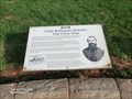
 view gallery view galleryNE20.9 km | William L. "Mudwall" Jackson in West Virginia Historical Markers Born in Clarksburg in 1825 and was promoted to brigadier general in 1864. posted by: dukemartin location: West Virginia date approved: 07/11/2021 last visited: never |
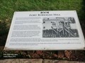 view gallery view galleryNE20.9 km |  Fort Boreman Hill - Parkersburg WV Fort Boreman Hill - Parkersburg WV
in Signs of History The prominent known locally as Fort Boreman Hill encompasses almost 250 acres. However, the actual site of Fort Boreman, its gun stations, powder magazine, and winter quarters, utilized only a small portion of the hill. posted by: Don.Morfe location: West Virginia date approved: 08/28/2020 last visited: 09/26/2021 |
 view gallery view galleryNE20.9 km | Fort Boreman During the Civil War - Parkersburg WV in Signs of History Fort Boreman was a military fortification constructed by the United States Army during the Civil War. The protection of the Baltimore & Ohio Railroad, the two turnpikes, the Northwestern and the Staunton-Parkersburg was absolutely essential. posted by: Don.Morfe location: West Virginia date approved: 08/28/2020 last visited: 09/26/2021 |
 view gallery view galleryNE20.9 km |  Fort Boreman During the Civil War - Parkersburg WV Fort Boreman During the Civil War - Parkersburg WV
in U.S. Civil War Sites Fort Boreman was a military fortification constructed by the United States Army during the Civil War. The protection of the Baltimore & Ohio Railroad, the two turnpikes, the Northwestern and the Staunton-Parkersburg was absolutely essential. posted by: Don.Morfe location: West Virginia date approved: 08/28/2020 last visited: 10/04/2021 |
 view gallery view galleryNE20.9 km | Parkersburg in 1861 - Parkersburg WV in Signs of History At the beginning of the Civil War, Parkersburg had a population of 2,500. The completion of the southern branch of the Baltimore & Ohio Railroad to the town in 1857 increased the size and importance of Parkersburg. posted by: Don.Morfe location: West Virginia date approved: 08/28/2020 last visited: 09/26/2021 |
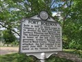 view gallery view galleryNE20.9 km | Fort Boreman in West Virginia Historical Markers Built in 1863 on Mount Logan it was never attacked. posted by: dukemartin location: West Virginia date approved: 07/11/2021 last visited: never |
 view gallery view galleryNE21.1 km | Historic Blennerhassett Island - Parkersburg WV in Signs of History One and one-half miles below the confluence of the Ohio and Little Kanawha rivers lies historic Blennerhassett Island, home of the Irish aristocrat Harman Blennerhassett and his wife Margaret from 1798 to 1806. posted by: Don.Morfe location: West Virginia date approved: 08/28/2020 last visited: 09/26/2021 |
|