 view gallery view gallery SE3.5 km SE3.5 km
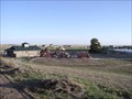
|   Homestead Ranch Region Park Playground, El Paso County, Colorado Homestead Ranch Region Park Playground, El Paso County, Colorado
in Public Playgrounds A nice, pretty extensive playground in the New Homestead Ranch Regional Park. posted by:  WitzAbout WitzAbout location: Colorado date approved: 04/29/2007 last visited: never |
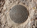
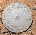
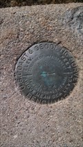
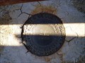
 view gallery view gallerySE4.5 km |  DIVIDE (KK1646) - El Paso County, Colorado DIVIDE (KK1646) - El Paso County, Colorado
in U.S. Benchmarks A triangulation station from 1879 on top of a small butte about 3.5 miles to the north-northeast of Peyton, Colorado. posted by: Tom.dog location: Colorado date approved: 11/04/2022 last visited: never |
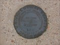
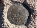
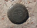
 view gallery view gallerySE4.5 km | DIVIDE Reference Mark 1 - El Paso County, Colorado in U.S. Benchmarks The lone reference mark of triangulation station DIVIDE. posted by: Tom.dog location: Colorado date approved: 11/04/2022 last visited: never |
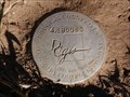
 view gallery view gallery SW5.8 km SW5.8 km
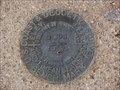
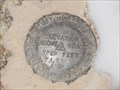
| D 295 (KK0286) - El Paso County, Colorado in U.S. Benchmarks A benchmark disk in the northwest corner of the intersection of Hodgen Road and Meridian Road. posted by: Tom.dog location: Colorado date approved: 11/06/2022 last visited: never |
 view gallery view gallery N9.5 km N9.5 km
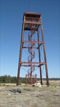
|  Kimsey Tower - Elbert County, CO Kimsey Tower - Elbert County, CO
in Citizen Memorials The Kimsey Tower is located on the grounds of the Peaceful Valley Scouts Ranch. posted by:  condor1 condor1 location: Colorado date approved: 03/07/2011 last visited: 03/06/2011 |
 view gallery view gallery W9.7 km W9.7 km
| 2 A.T.W - El Paso County, Colorado in U.S. Benchmarks USGS Benchmark in Northern El Paso County, Colorado. posted by: Tom.dog location: Colorado date approved: 12/11/2013 last visited: never |
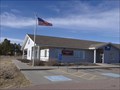 view gallery view gallerySE10 km |  Peyton, Colorado 80831 Peyton, Colorado 80831
in U.S. Post Offices Where Colorado Highway bends from East-West to South-West North-East, is the little town of Peyton. posted by: WitzAbout location: Colorado date approved: 11/17/2008 last visited: 05/14/2014 |
 view gallery view gallerySE10 km |  Rock Island - El Paso County, CO Rock Island - El Paso County, CO
in Rails to Trails This relativly new trail (less than 10 years old) connects the towns of Peyton and Falcon, CO. Developed as part of the National Rail to Trails Program. posted by: condor1 location: Colorado date approved: 10/17/2011 last visited: 05/14/2014 |
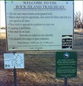
 view gallery view gallerySE10 km |  Rock Island Trailhead - Peyton, CO Rock Island Trailhead - Peyton, CO
in Hiking and walking trailheads This relativly new trail connects the towns of Peyton and Falcon, CO posted by: condor1 location: Colorado date approved: 03/29/2009 last visited: 05/14/2014 |
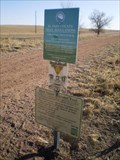
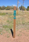 view gallery view gallerySE10 km |  Rock Island Regional Trail Mileage Markers Rock Island Regional Trail Mileage Markers
in Eagle Scout Project Sites This Eagle Scout Project to install mileposts for the Rock Island Regional Trail starts just across the street south of the post office at 7495 McLaughlin Road in Peyton, Colorado. posted by: brwhiz location: Colorado date approved: 02/13/2013 last visited: 05/14/2014 |
 view gallery view gallerySE10 km | Colorado DOT State Hwy 24 Mile Post 329.53 in U.S. Benchmarks This Colorado Department of Transportation right-of-way mark is located on the southwest corner of the junction of US Highway 24 and Bradshaw Road in Peyton, Colorado. posted by: brwhiz location: Colorado date approved: 01/23/2013 last visited: 05/14/2014 |
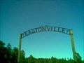 view gallery view gallerySW10.8 km |  Eastonville Cemetery - El Paso County, CO Eastonville Cemetery - El Paso County, CO
in Worldwide Cemeteries Rural Cemetery in the country side of Colorado.........Coords are for the Entrance posted by: condor1 location: Colorado date approved: 11/27/2008 last visited: 06/05/2010 |
 view gallery view galleryW11.3 km | 1 BB (KK0282) - El Paso County, Colorado in U.S. Benchmarks A USGS benchmark in the southwest corner of the intersection of Hodgen and Bar X Roads. posted by: Tom.dog location: Colorado date approved: 11/06/2022 last visited: never |
 view gallery view gallery S13.7 km S13.7 km
| B 52 (JK0271) - El Paso County, Colorado in U.S. Benchmarks An uprooted and re-positioned benchmark on the southeast side of Eastonville Road. posted by: Tom.dog location: Colorado date approved: 11/16/2022 last visited: never |
 view gallery view galleryN14.5 km | 4 A.T.W - Elbert County, Colorado in U.S. Benchmarks USGS Benchmark northwest of Elbert, Colorado. posted by: Tom.dog location: Colorado date approved: 12/14/2013 last visited: never |
 view gallery view galleryW15.3 km | 4.180060 - Douglas County, Colorado in U.S. Benchmarks Douglas County GIS Secondary Control Monument on County Line Rd. posted by: Tom.dog location: Colorado date approved: 12/22/2013 last visited: never |
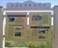 view gallery view gallerySE16.1 km |  Towns Along The Tracks - Peyton, CO Towns Along The Tracks - Peyton, CO
in Colorado Historical Markers This 4-Panel Colorado Historical Marker is located just west of the intersection of US-24 and N. Ellicot Hwy. Identified as CHS Marker #266. There is ample safe parking so you can take your time to read all of the panels. posted by: condor1 location: Colorado date approved: 08/17/2010 last visited: 05/14/2014 |
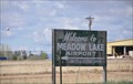 view gallery view galleryS16.3 km |  Meadow Lake Airport ~ Peyton, Colorado Meadow Lake Airport ~ Peyton, Colorado
in Airports This Airport is located at 13625 Judge Orr Road in Peyton, Colorado. It is Colorado's largest pilot-owned airport. posted by: brwhiz location: Colorado date approved: 02/15/2013 last visited: never |
 view gallery view galleryS16.4 km | E 24 - Falcon, CO in U.S. Benchmarks This Benchmark is located just east of Falcon, CO posted by: condor1 location: Colorado date approved: 03/09/2009 last visited: 01/02/2013 |
 view gallery view gallery NW17.4 km NW17.4 km
| TT 3B (AA3438) - Douglas County, Colorado in U.S. Benchmarks A USGS benchmark located at the intersection of E Cherry Creek Road and Steele Avenue. posted by: Tom.dog location: Colorado date approved: 11/16/2022 last visited: never |
 view gallery view galleryW17.4 km |  Pine Grove School - Colorado Springs, CO Pine Grove School - Colorado Springs, CO
in One-Room Schoolhouses This one room schoolhouse was in service from 1912 to 1938. posted by: Johnny_Quest location: Colorado date approved: 08/04/2010 last visited: never |
 view gallery view gallerySW17.5 km | Black Forest, Colorado 80908 in U.S. Post Offices Located along the east side of Black Forest Rd, about 8 miles north of the Colorado Springs city boundry. posted by: condor1 location: Colorado date approved: 08/08/2009 last visited: 08/20/2009 |
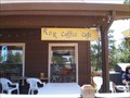 view gallery view gallerySW17.5 km |  R & R Coffee Cafe - Black Forest, CO R & R Coffee Cafe - Black Forest, CO
in Independent Coffee Shops The R & R Coffee Cafe is located in the area known as Black Forest which is just north of Colorado Springs. The shop is on the east side of Black Forest Rd. posted by: condor1 location: Colorado date approved: 08/09/2009 last visited: 02/23/2011 |
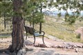 view gallery view gallerySW17.9 km |  Henry Hoover Memorial Bench, El Paso County, Colorado Henry Hoover Memorial Bench, El Paso County, Colorado
in Dedicated Benches A memorial bench in a park posted by: toponym location: Colorado date approved: 09/11/2020 last visited: never |
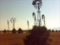 view gallery view galleryS17.9 km |  Where the Windmills Grow - Falcon, CO Where the Windmills Grow - Falcon, CO
in Windmills This wonderful collection of Old Style Windmills is located in the 'Platted Community' of Falcon Colorado. posted by: condor1 location: Colorado date approved: 09/27/2009 last visited: 01/02/2013 |
|