 view gallery view gallery SW3.7 km SW3.7 km
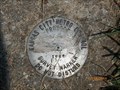
|   JA-66 JA-66
in U.S. Benchmarks The station is KC Metro aluminum GRS disk set in concrete and flush with the ground. The station is stamped JA-66, 1988 posted by:  tengland66 tengland66 location: Missouri date approved: 09/18/2011 last visited: 07/10/2011 |
 view gallery view gallery NE4.2 km NE4.2 km
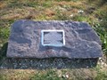
|  Potawatomi Trail of Death Marker Potawatomi Trail of Death Marker
in Trail of Tears A marker on the Potawatomi Trail of Death, near Independence, MO. It is located on the Little Blue Trace hiking & bicylcing trail near highway M-78. posted by:  mapfan1 mapfan1 location: Missouri date approved: 11/02/2010 last visited: never |
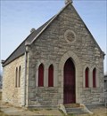
 view gallery view gallerySW5.3 km |  Luttrell Cemetery - Independence, Missouri Luttrell Cemetery - Independence, Missouri
in Worldwide Cemeteries An old cemetery in the City of Independence, Milton Estates. posted by: Woobie491 location: Missouri date approved: 05/23/2012 last visited: 09/15/2019 |
 view gallery view gallerySW5.3 km |  Redhead Chevrolet 3100 Pickup Redhead Chevrolet 3100 Pickup
in Permanent Car Displays This vintage Chevrolet pickup truck is located inside the Bass Pro Shops outlet at 18001 Bass Pro Drive in Independence, Missouri. posted by: brwhiz location: Missouri date approved: 12/16/2012 last visited: never |
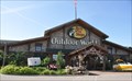 view gallery view gallerySW5.3 km |  Bass Pro Shops Outdoor World Independence Bass Pro Shops Outdoor World Independence
in Outdoor Recreation Stores This Bass Pro Shops outlet is located at 18001 Bass Pro Drive in Independence, Missouri. posted by: brwhiz location: Missouri date approved: 02/20/2013 last visited: never |
 view gallery view gallerySW5.5 km |  Bass Pro Shops Penny Smasher Bass Pro Shops Penny Smasher
in Penny Smashers This four-design hand-cranked Penny Smasher is in the Bass Pro Shops store in Independence, Missouri. posted by: brwhiz location: Missouri date approved: 08/23/2012 last visited: never |
 view gallery view gallery N5.8 km N5.8 km
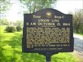
|  Union Line - Independence, Mo. Union Line - Independence, Mo.
in Missouri Historical Markers This marker is located in a small roadside park at the corner of US Hwy 24 and Old Lexington Road. posted by: iconions location: Missouri date approved: 07/22/2012 last visited: 09/07/2009 |
 view gallery view galleryN5.8 km |  Santa Fe Trail Marker - Salem Church Santa Fe Trail Marker - Salem Church
in Wagon Roads and Trails Santa Fe Trail marker placed just off of Hwy 24 on the east side of Independence. posted by: betaylor73 location: Missouri date approved: 02/22/2009 last visited: 10/01/2019 |
 view gallery view galleryN5.8 km |  Battle of the Little Blue River - Independence, Mo. Battle of the Little Blue River - Independence, Mo.
in Battlefields This marker is located in a small roadside park at the corner of US Hwy 24 and Old Lexington Road. posted by: iconions location: Missouri date approved: 07/22/2012 last visited: 04/01/2012 |
 view gallery view galleryN5.8 km |  Battle of the Little Blue River - Independence, Mo. Battle of the Little Blue River - Independence, Mo.
in 'You Are Here' Maps This marker is located in a small roadside park at the corner of US Hwy 24 and Old Lexington Road. posted by: iconions location: Missouri date approved: 07/22/2012 last visited: 04/01/2012 |
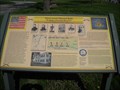 view gallery view galleryN5.8 km | Battle of the Little Blue River - Independence, Mo. in Missouri Historical Markers This marker is located in a small roadside park at the corner of US Hwy 24 and Old Lexington Road. posted by: iconions location: Missouri date approved: 07/22/2012 last visited: 10/01/2019 |
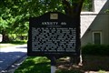 view gallery view gallery W6 km W6 km
| Anxiety 4th in Missouri Historical Markers Historic landmark in Independence. posted by: Woobie491 location: Missouri date approved: 05/17/2012 last visited: 09/18/2017 |
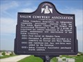 view gallery view galleryN6 km | Salem Cemetery Association - Independence, Mo. in Missouri Historical Markers This marker is located at the entrance to the New Salem Baptist Church Cemetery - 1805 N. Blue Mills Rd. posted by: iconions location: Missouri date approved: 07/22/2012 last visited: 04/01/2012 |
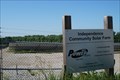 view gallery view galleryNE6 km |  Independence Community Solar Farm - Independence, MO Independence Community Solar Farm - Independence, MO
in Solar Power Utility scale photovoltaic solar farm located at 24451 E. Bundschu Road, Independence, MO. posted by: wardnkathy location: Missouri date approved: 06/18/2018 last visited: never |
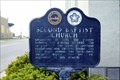 view gallery view galleryW6.1 km | Second Baptist Church - Independence, MO in Missouri Historical Markers A Bicentennial marker for the church. posted by: Markerman62 location: Missouri date approved: 02/02/2015 last visited: 08/17/2019 |
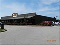 view gallery view gallerySW6.1 km |  Cracker Barrel - I-70 , Exit 14, Independence, Missouri Cracker Barrel - I-70 , Exit 14, Independence, Missouri
in Cracker Barrel Restaurants Cracker Barrel - I-70, Exit 14, Independence, Missouri 64055 posted by: walkingwildly location: Missouri date approved: 08/23/2015 last visited: 10/31/2015 |
 view gallery view galleryW6.1 km |  Michael Tuite - Woodlawn Cemetery - Independence, Mo. Michael Tuite - Woodlawn Cemetery - Independence, Mo.
in Woodmen of the World Grave Markers/Monuments This is a limestone "tree trunk" headstone located in the Woodlawn Cemetery - 701 South Noland Road. posted by: iconions location: Missouri date approved: 02/11/2012 last visited: never |
 view gallery view galleryW6.3 km |  1889 - Sawyer Mausoleum - Woodlawn Cemetery - Independence, Mo. 1889 - Sawyer Mausoleum - Woodlawn Cemetery - Independence, Mo.
in Dated Buildings and Cornerstones This very impressive mausoleum in the shape of a chapel is located in the Woodlawn Cemetery - 701 South Noland Road. posted by: iconions location: Missouri date approved: 02/11/2012 last visited: never |
 view gallery view galleryW6.3 km |  Sawyer Mausoleum - Woodlawn Cemetery - Independence, Mo. Sawyer Mausoleum - Woodlawn Cemetery - Independence, Mo.
in Mausoleums This very impressive mausoleum in the shape of a chapel is located in the Woodlawn Cemetery - 701 South Noland Road. posted by: iconions location: Missouri date approved: 02/11/2012 last visited: never |
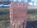
 view gallery view galleryW6.3 km |  John Taylor Hughes - Independence, Mo. John Taylor Hughes - Independence, Mo.
in Graves Mentioning a Cause of Death This is the final resting place of Brigadier General John Taylor Hughes. Woodlawn Cemetery is located at 701 South Noland Road in Independence, Mo. posted by: iconions location: Missouri date approved: 07/08/2017 last visited: never |
 view gallery view galleryW6.3 km |  John Taylor Hughes - Woodlawn Cemetery - Independence, Mo. John Taylor Hughes - Woodlawn Cemetery - Independence, Mo.
in Grave of a Famous Person This is the final resting place of Brigadier General John Taylor Hughes. Woodlawn Cemetery is located at 701 South Noland Road in Independence, Mo. posted by: iconions location: Missouri date approved: 02/09/2012 last visited: 05/02/2012 |
 view gallery view galleryW6.3 km | John R Boyd - Independence, Mo. in Graves Mentioning a Cause of Death This is the final resting place of Colonel John R Boyd. Woodlawn Cemetery is located at 701 South Noland Road in Independence, Mo. posted by: iconions location: Missouri date approved: 07/08/2017 last visited: 05/02/2012 |
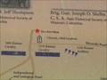
 view gallery view galleryW6.4 km |  Confederate Memorial - Woodlawn Cemetery - Independence, Mo. Confederate Memorial - Woodlawn Cemetery - Independence, Mo.
in American Civil War Monuments and Memorials This 20 foot tall obelisk is located in the Woodlawn Cemetery - 701 South Noland Road. posted by: iconions location: Missouri date approved: 02/12/2012 last visited: 05/02/2012 |
 view gallery view galleryW6.4 km |  Confederate Memorial Obelisk - Woodlawn Cemetery - Independence, Mo. Confederate Memorial Obelisk - Woodlawn Cemetery - Independence, Mo.
in Obelisks This 20 foot tall obelisk is located in the Woodlawn Cemetery - 701 South Noland Road. posted by: iconions location: Missouri date approved: 02/11/2012 last visited: never |
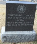 view gallery view galleryW6.4 km | Theodore T. Gray - Woodlawn Cemetery - Independence, Mo. in Woodmen of the World Grave Markers/Monuments This is a Black marble slab headstone located in the Woodlawn Cemetery - 701 South Noland Road. posted by: iconions location: Missouri date approved: 02/07/2012 last visited: never |
|