 view gallery view gallery S0.8 km S0.8 km
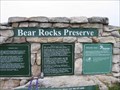
|   Bear Rocks Preserve Bear Rocks Preserve
in Public Access Lands Bear Rocks Preserve at Dolly Sods. posted by:  WhatTrail? WhatTrail? location: West Virginia date approved: 08/31/2008 last visited: never |
 view gallery view gallery NW0.8 km NW0.8 km
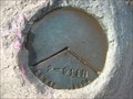
|  USFS Land Survey Marker 2-911N USFS Land Survey Marker 2-911N
in U.S. Benchmarks Survey marker at Bear Rocks, Monongahela National Forest posted by: jkselby location: West Virginia date approved: 08/11/2010 last visited: 05/18/2012 |
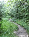
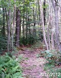
 view gallery view galleryS4.7 km |  Blackbird Knob Trail - Dolly Sods Wilderness- Monongahela National Forest - Dry Run, West Virginia Blackbird Knob Trail - Dolly Sods Wilderness- Monongahela National Forest - Dry Run, West Virginia
in Hiking and walking trailheads The Blackbird Knob Trail of the Dolly Sods Wilderness of the Monongahela National Forest and is located off of Forest Road 75 in Grant County, West Virginia. posted by: outdoorboy34 location: West Virginia date approved: 06/30/2012 last visited: never |
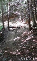
 view gallery view galleryS7.9 km | Wildlife Trail - Dolly Sods Wilderness - Monongahela National Forest - Dry Run, West Virginia in Hiking and walking trailheads The Wildlife Trail of the Dolly Sods Wilderness of the Monongahela National Forest and is located off of Forest Road 75 in Grant County, West Virginia posted by: outdoorboy34 location: West Virginia date approved: 06/30/2012 last visited: never |
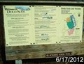
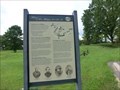
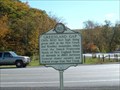
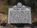 view gallery view galleryS10.1 km |  Smoke Hole Smoke Hole
in West Virginia Historical Markers A sign describing the smoke hole canyon. posted by:  dukemartin dukemartin location: West Virginia date approved: 04/17/2017 last visited: 04/17/2017 |
 view gallery view galleryS11.3 km | Rohrbaugh Plains Trail - Dolly Sods Wilderness- Monongahela National Forest - Dry Run, West Virginia in Hiking and walking trailheads The Rohrbaugh Plains Trail of the Dolly Sods Wilderness of the Monongahela National Forest and is located off of Forest Road 75 in Grant County, West Virginia. posted by: outdoorboy34 location: West Virginia date approved: 06/30/2012 last visited: never |
 view gallery view gallery SE11.4 km SE11.4 km
|  Cabins, WV 26855 Cabins, WV 26855
in U.S. Post Offices Cabins WV 26855 Post Office posted by: dukemartin location: West Virginia date approved: 06/06/2012 last visited: never |
 view gallery view gallery E13.2 km E13.2 km
| Maysville, WV 26833 in U.S. Post Offices Maysville WV 26833 Post Office posted by: dukemartin location: West Virginia date approved: 05/31/2012 last visited: never |
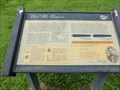
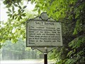
 view gallery view gallery W13.2 km W13.2 km
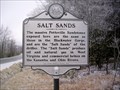
| Salt Sands in West Virginia Historical Markers A sign telling us what the "salt sands" produce. posted by: Paintedwarrior location: West Virginia date approved: 12/09/2013 last visited: 12/14/2013 |
 view gallery view gallery SW14.2 km SW14.2 km
| Red Creek Trailhead - Dolly Sods Wilderness - Monongahela National Forest - Dry Run, West Virginia in Hiking and walking trailheads The Red Creek Trail of the Dolly Sods Wilderness of the Monongahela National Forest and is located on Forest Road 19 in Tucker County, West Virginia. posted by: outdoorboy34 location: West Virginia date approved: 06/30/2012 last visited: never |
 view gallery view gallerySW14.2 km |  Canaan Valley Ski Resort - Tucker County, WV Canaan Valley Ski Resort - Tucker County, WV
in Winter Sports Locations Located in the heart of Tucker Valley. The resort is posted by: flyingmoose location: West Virginia date approved: 02/08/2021 last visited: never |
 view gallery view galleryNW15.8 km | Davis WV 26260 Post Office in U.S. Post Offices Davis WV 26260 Post Office posted by: dukemartin location: West Virginia date approved: 12/30/2013 last visited: never |
 view gallery view gallerySE15.8 km | Petersburg, WV 26847 in U.S. Post Offices Petersburg WV 26847 Post Office posted by: dukemartin location: West Virginia date approved: 06/06/2012 last visited: never |
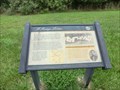
 view gallery view gallerySE15.9 km |  Welcome to Fort Mulligan Civil War Site - Petersburg WV Welcome to Fort Mulligan Civil War Site - Petersburg WV
in U.S. Civil War Sites Exploring Fort Mulligan. A trail system with interpretive exhibits describe the Fort’s construction, usage and strategic importance during the Civil War. posted by: Don.Morfe location: West Virginia date approved: 08/29/2020 last visited: 10/04/2021 |
 view gallery view gallerySE15.9 km | Civil War Cannons - Petersburg WV in U.S. Civil War Sites This is one of at least seven known gun positions at Fort Mulligan (note the depression in the angle), which would have dominated the crossroads at Petersburg and its ford on the South Branch of the Potomac River. posted by: Don.Morfe location: West Virginia date approved: 08/29/2020 last visited: 10/04/2021 |
 view gallery view gallerySE15.9 km | Fort Mulligan in West Virginia Historical Markers Tells about a fort built on a hill just outside of Petersburg WV. posted by: dukemartin location: West Virginia date approved: 08/13/2019 last visited: never |
 view gallery view gallerySE15.9 km | A Strategic Location - Petersburg WV in U.S. Civil War Sites The strategic importance of Fort Mulligan becomes evident as you observe the surrounding terrain. posted by: Don.Morfe location: West Virginia date approved: 08/29/2020 last visited: 10/04/2021 |
 view gallery view galleryW16.6 km | Salt Sands in West Virginia Historical Markers Located in Blackwater Falls State Park. posted by: two-bit Joe location: West Virginia date approved: 03/07/2008 last visited: 10/14/2021 |
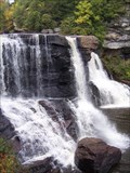 view gallery view galleryW16.6 km |  Blackwater Falls Blackwater Falls
in Waterfalls Blackwater Falls in Blackwater Falls State Park. posted by: Rev Mike location: West Virginia date approved: 10/19/2008 last visited: 08/09/2022 |
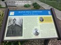 view gallery view gallerySE17.1 km | Maple Hill Cemetery-Brief Peace in the Midst of War - Petersburg WV in U.S. Civil War Sites Marker is in Petersburg, West Virginia, in Grant County on North Main Street located in Maple Hill Cemetery, 301 North Main Street, Petersburg WV 26847. posted by: Don.Morfe location: West Virginia date approved: 07/11/2023 last visited: 07/11/2023 |
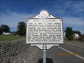
 view gallery view gallery NE17.4 km NE17.4 km
| Greenland Gap in West Virginia Historical Markers Cliffs 800 feet high lining great cleft in the New Creek and Knobley mountains posted by: two-bit Joe location: West Virginia date approved: 03/26/2011 last visited: 07/03/2012 |
 view gallery view gallerySE17.7 km | Petersburg in West Virginia Historical Markers Tells when Petersburg was settled and works of Rev. W. N. Scott. posted by: Paintedwarrior location: West Virginia date approved: 07/07/2012 last visited: 09/01/2004 |
 view gallery view gallerySE17.7 km | Fort Mulligan Protecting Looney's Creek (Petersburg) - Petersburg WV in U.S. Civil War Sites Marker is in Petersburg, West Virginia, in Grant County at the intersection of Virginia Avenue (West Virginia Route 55) and Bush Lane,
115 Virginia Ave, Petersburg WV. posted by: Don.Morfe location: West Virginia date approved: 07/11/2023 last visited: 07/11/2023 |
 view gallery view gallerySE17.9 km | War in Grant County Engagement at Johnson Run - Petersburg WV in U.S. Civil War Sites Marker is in Petersburg, West Virginia, in Grant County at the intersection of South Main Street (U.S. 220) and C Street, Petersburg WV 26847. posted by: Don.Morfe location: West Virginia date approved: 07/11/2023 last visited: 07/11/2023 |
 view gallery view gallerySE17.9 km | War in Grant County-Engagement at Johnson Run - Petersburg WV in Civil War Discovery Trail Sites During the Civil War, loyal Unionist Home Guard companies patrolled Hardy County (now Grant County) to defend it against Confederate incursions. posted by: Don.Morfe location: West Virginia date approved: 08/29/2020 last visited: 10/04/2021 |
|