 view gallery view gallery S0.8 km S0.8 km
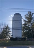
|   Merry-Go-Round Farm Silo - Potomac, Maryland Merry-Go-Round Farm Silo - Potomac, Maryland
in Solitary Silos Located on the eastbound side of river road. posted by:  flyingmoose flyingmoose location: Maryland date approved: 03/16/2021 last visited: never |
 view gallery view gallery SW1.4 km SW1.4 km
|  C&O Canal - Lock #22 C&O Canal - Lock #22
in Waterway Locks, Planes and Lifts Lock #22 (of 74) on the Chesapeake and Ohio Canal - Pennyfield Lock posted by:  ParrotRob ParrotRob location: Maryland date approved: 06/12/2006 last visited: 06/14/2013 |
 view gallery view gallerySW1.4 km |  Lockhouse 22 - Potomac, Maryland Lockhouse 22 - Potomac, Maryland
in Signs of History Historic Building along the Chesapeake and Ohio Canal. posted by: flyingmoose location: Maryland date approved: 08/02/2023 last visited: never |
 view gallery view gallery W2.7 km W2.7 km
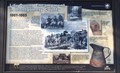
|  Life during encampment in Montgomery county - Potomac, Maryland Life during encampment in Montgomery county - Potomac, Maryland
in U.S. Civil War Sites Located on the edge of the main Blockhouse Park lot. posted by: flyingmoose location: Maryland date approved: 03/18/2021 last visited: never |
 view gallery view galleryW2.7 km | Travelers impression of Montgomery county- Potomac, Maryland in U.S. Civil War Sites Civil War sign located on the edge of the main Blockhouse Park lot. posted by: flyingmoose location: Maryland date approved: 03/18/2021 last visited: never |
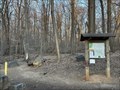
 view gallery view gallerySW4 km |  Fraser Preserve - Great Falls, Virginia Fraser Preserve - Great Falls, Virginia
in Hiking and walking trailheads Located at the end of Springvale Road. posted by: flyingmoose location: Virginia date approved: 10/30/2021 last visited: never |
 view gallery view gallery SE4.2 km SE4.2 km
| C&O Canal - Lock #21 in Waterway Locks, Planes and Lifts Lock #21 (of 74) on the Chesapeake and Ohio Canal - Swain's Lock - Mile 16.64 posted by: ParrotRob location: Maryland date approved: 06/03/2006 last visited: 10/27/2000 |
 view gallery view gallerySE4.7 km |  Riverbend Nature Center Riverbend Nature Center
in Nature Centers Located off the beaten path in Northern Virginia is this little Nature Center posted by: flyingmoose location: Virginia date approved: 03/31/2008 last visited: 07/07/2013 |
 view gallery view galleryW4.8 km | Lock #23 - Violets Lock in Waterway Locks, Planes and Lifts Lock #23 (of 74) on the Chesapeake and Ohio Canal - Violets Lock posted by: flyingmoose location: Maryland date approved: 02/20/2008 last visited: 03/23/2012 |
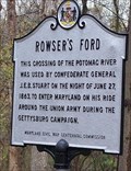 view gallery view galleryW4.8 km |  Rowser's Ford Rowser's Ford
in Maryland Historical Markers Rowser's Ford posted by: mrfixitman location: Maryland date approved: 04/07/2006 last visited: 03/23/2012 |
 view gallery view gallerySE5.1 km |  Pollinator Garden - Great Falls, Virginia Pollinator Garden - Great Falls, Virginia
in Girl Scout Gold Award Project Sites Located in front of the visitor center at Riverbend Park. posted by: flyingmoose location: Virginia date approved: 03/14/2021 last visited: never |
 view gallery view galleryW5.3 km | Crossing The Potomac - Great Falls, Virginia in U.S. Civil War Sites Located at the entrance of Seneca Park. posted by: flyingmoose location: Virginia date approved: 04/27/2023 last visited: never |
 view gallery view galleryW5.3 km | Rowsers Ford - Great Falls, Virginia in Civil War Discovery Trail Sites Located at the entrance of Seneca Park. posted by: flyingmoose location: Virginia date approved: 05/13/2023 last visited: never |
 view gallery view galleryW5.3 km | Seneca Regional Park - Great Falls, Virginia in Hiking and walking trailheads Located at the northern end of Seneca Road posted by: flyingmoose location: Virginia date approved: 04/28/2023 last visited: never |
 view gallery view gallerySE5.3 km |  River Bend Park Boat Ramp River Bend Park Boat Ramp
in Boat Ramps Located at the Visitor Center in Riverbend Park. posted by: flyingmoose location: Virginia date approved: 03/31/2008 last visited: 07/07/2013 |
 view gallery view gallery N5.5 km N5.5 km
| Darnestown Confederate Visit - Darnestown MD in U.S. Civil War Sites Gen. Wade Hampton's brigade turned north up Seneca Road to Darnestown, becoming the first Confederate force to enter the small town. Near hear, Hampton captured 25 teams of mules heading for Edwards Ferry. posted by: Don.Morfe location: Maryland date approved: 03/26/2023 last visited: 04/02/2023 |
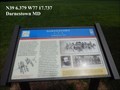 view gallery view galleryN5.5 km | Darnestown-Confederate Visit - Darnestown, MD in Civil War Discovery Trail Sites On June 25-27, 1863, the Federal Army of the Potomac used two temporary pontoon bridges to cross the Potomac River from Virginia back into Maryland at Edwards Ferry. posted by: Don.Morfe location: Maryland date approved: 03/19/2020 last visited: 10/08/2021 |
 view gallery view galleryW5.8 km |  Riley's Lock - Seneca MD Riley's Lock - Seneca MD
in Wikipedia Entries Riley's Lock (Lock 24) and lock house are part of the 184.5-mile (296.9 km) Chesapeake and Ohio Canal (a.k.a. C&O Canal) that operated in the United States along the Potomac River from the 1830s through 1923. posted by: Don.Morfe location: Maryland date approved: 10/24/2021 last visited: 01/09/2022 |
 view gallery view galleryW5.8 km | Seneca Lock 24, C & O Canal - Poolesville MD in Signs of History The Seneca Creek Aqueduct, or Aqueduct Number One, Lock 24, and the lockhouse were built of Seneca Red Stone quarried nearby. This same distinctive sandstone was used to construct the Smithsonian Castle on the Washington Mall. posted by: Don.Morfe location: Maryland date approved: 07/21/2022 last visited: 07/22/2022 |
 view gallery view galleryW5.8 km | Riley's Lock 24 C & O Canal- Seneca MD in Waterway Locks, Planes and Lifts Riley's Lock (Lock 24) and lock house are part of the 184.5-mile (296.9 km) Chesapeake and Ohio Canal (a.k.a. C&O Canal) that operated in the United States along the Potomac River from the 1830s through 1923. posted by: Don.Morfe location: Maryland date approved: 10/25/2021 last visited: 01/09/2022 |
 view gallery view galleryW5.8 km | Poolesville, Maryland in Wikipedia Entries The GPS coordinates are for Seneca Aqueduct Lock 24, C & O Canal in Poolesville MD. Poolesville is a U.S. town in the western portion of Montgomery County, Maryland. The population was 5,742 at the 2020 United States Census. posted by: Don.Morfe location: Maryland date approved: 06/14/2024 last visited: 03/24/2012 |
 view gallery view galleryW5.8 km | Seneca Aqueduct - Poolesville MD in Wikipedia Entries Seneca Aqueduct was built from 1829 to 1832 with three red sandstone arches quarried in the nearby Seneca Quarry, just a few hundred feet to the west. posted by: Don.Morfe location: Maryland date approved: 07/22/2022 last visited: 04/02/2023 |
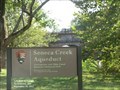 view gallery view galleryW5.8 km | ") Seneca Creek Aqueduct and Lock 24-Chesapeake and Ohio National Historical Park - Poolesville MD Seneca Creek Aqueduct and Lock 24-Chesapeake and Ohio National Historical Park - Poolesville MD
in National Parks (U.S.) Lock 24 “Rileys” & Seneca Aqueduct--The C&O Canal had 11 aqueducts and 74 lift locks... but one was both a lift lock and an aqueduct! This engineering marvel is located at mile 22.7, at the mouth of Seneca Creek. posted by: Don.Morfe location: Maryland date approved: 08/12/2022 last visited: 04/02/2023 |
 view gallery view galleryW5.8 km |  Seneca Creek Aqueduct and Lock 24-Chesapeake and Ohio National Historical Park - Poolesville MD Seneca Creek Aqueduct and Lock 24-Chesapeake and Ohio National Historical Park - Poolesville MD
in National Parks of the World Lock 24 “Rileys” & Seneca Aqueduct--The C&O Canal had 11 aqueducts and 74 lift locks... but one was both a lift lock and an aqueduct! This engineering marvel is located at mile 22.7, at the mouth of Seneca Creek. posted by: Don.Morfe location: Maryland date approved: 07/28/2022 last visited: 04/02/2023 |
 view gallery view galleryW5.8 km |  Rowser’s Ford-5,000 Confederate Cavalrymen Crossed - Poolesville, MD Rowser’s Ford-5,000 Confederate Cavalrymen Crossed - Poolesville, MD
in Battlefields On June 24, 1863, Gen. J.E.B. Stuart, leaving 3,000 cavalrymen in Rectortown, Virginia, to monitor Federal activity, led three Confederate cavalry brigades to Haymarket. posted by: Don.Morfe location: Maryland date approved: 05/04/2024 last visited: 03/23/2012 |
|