 view gallery view gallery SW1.8 km SW1.8 km
|   Gettysburg Campaign Gettysburg Campaign
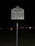
in Virginia Historical Markers This marker is located on the western side of Potomac View Road in Sterling Va.. Parking in front of the sign is safe and perfectly legal, just not for extended periods of time.
This is also one of the few markers I have not seen in the database. posted by:  flyingmoose flyingmoose location: Virginia date approved: 05/25/2006 last visited: 06/25/2017 |
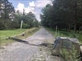
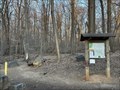
 view gallery view gallerySW1.9 km |  Ambush At Anker's Shop - Sterling, Virginia Ambush At Anker's Shop - Sterling, Virginia
in Civil War Discovery Trail Sites Civil War site located in front of the Loudoun campus of Northern Virginia Community College posted by: flyingmoose location: Virginia date approved: 08/03/2020 last visited: never |
 view gallery view gallery W1.9 km W1.9 km
|  Cascades Marketplace Cascades Marketplace
in Red Telephone Boxes Located in the center of Cascades shopping center this easily stands out. posted by: flyingmoose location: Virginia date approved: 04/08/2008 last visited: 06/30/2011 |
 view gallery view gallery S2.4 km S2.4 km
| Loudoun County in Virginia Historical Markers Located in the median strip along Route 7. There is plenty of parking nearby but not really any safe access unless it is very early sunday morning or late night during the week. posted by: flyingmoose location: Virginia date approved: 05/25/2006 last visited: 06/25/2017 |
 view gallery view galleryS2.4 km |  Public Storage - Sterling, Virginia Public Storage - Sterling, Virginia
in Landlocked Lighthouses The landlocked lighthouse stands in front of the Sterling Public Storage. Easy to park and visit. posted by: flyingmoose location: Virginia date approved: 07/07/2020 last visited: never |
 view gallery view gallerySW2.6 km |  Target Greatland - Sterling, Virginia Target Greatland - Sterling, Virginia
in Target Stores Target Greatland located off Route 7/Cascades Parkway and Potomac Run Plaza in Sterling, Virginia posted by:  ahight ahight location: Virginia date approved: 02/27/2009 last visited: 06/25/2017 |
 view gallery view gallery N2.7 km N2.7 km
|  Algonkian Park Boat Ramp Algonkian Park Boat Ramp
in Boat Ramps Located at the end of the road in Algonkian Park. posted by: flyingmoose location: Virginia date approved: 03/31/2008 last visited: never |
 view gallery view galleryS3.1 km |  Bowl America - Sterling, Virginia Bowl America - Sterling, Virginia
in Bowling Centres Bowl America is a chain bowling center. It’s a big facility and plenty of parking. posted by: flyingmoose location: Virginia date approved: 07/05/2020 last visited: never |
 view gallery view galleryW3.1 km |  The Right Light The Right Light
in Figurative Public Sculpture This is a statue depicting an artist creating a painting. posted by: Buglady1 location: Virginia date approved: 07/06/2009 last visited: 06/25/2017 |
 view gallery view gallerySW3.4 km |  Heritage Farm Museum - Sterling, Virginia Heritage Farm Museum - Sterling, Virginia
in History Museums Located at the Claude Moore Park, this museum shows you life posted by: flyingmoose location: Virginia date approved: 02/22/2021 last visited: never |
 view gallery view gallerySW3.4 km |  John Deere Model A - Sterling, Virginia John Deere Model A - Sterling, Virginia
in Old Tractors An old John Deere tractor located in front of the Heritage Farm Museum. posted by: flyingmoose location: Virginia date approved: 02/22/2021 last visited: never |
 view gallery view gallerySW3.4 km |  Vestal's Gap Road - Sterling, Virginia Vestal's Gap Road - Sterling, Virginia
in Ancient Traces and Roads Located at the northern entrance of the Claude Moore Park. This is one of many sections that still exist in Virginia. posted by: flyingmoose location: Virginia date approved: 07/05/2020 last visited: never |
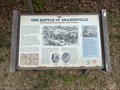 view gallery view galleryS3.5 km | The Battle Of Dranesville - Herndon, Virginia in U.S. Civil War Sites Located in front of the Drainsville Tavern. posted by: flyingmoose location: Virginia date approved: 05/13/2023 last visited: never |
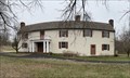 view gallery view galleryS3.5 km |  Dranesville Tavern - Herndon, Virginia Dranesville Tavern - Herndon, Virginia
in U.S. National Register of Historic Places Located on the eastbound side of Route 7. posted by: flyingmoose location: Virginia date approved: 04/28/2023 last visited: never |
 view gallery view gallery NE3.9 km NE3.9 km
|  Seneca Regional Park - Great Falls, Virginia Seneca Regional Park - Great Falls, Virginia
in Hiking and walking trailheads Located at the northern end of Seneca Road posted by: flyingmoose location: Virginia date approved: 04/28/2023 last visited: never |
 view gallery view galleryNE3.9 km | Rowsers Ford - Great Falls, Virginia in Civil War Discovery Trail Sites Located at the entrance of Seneca Park. posted by: flyingmoose location: Virginia date approved: 05/13/2023 last visited: never |
 view gallery view galleryNE3.9 km | Crossing The Potomac - Great Falls, Virginia in U.S. Civil War Sites Located at the entrance of Seneca Park. posted by: flyingmoose location: Virginia date approved: 04/27/2023 last visited: never |
 view gallery view galleryW4 km |  INOVA Blood Donor Services - Sterling, Virginia INOVA Blood Donor Services - Sterling, Virginia
in Blood Donation Centers INOVA is a large medical company that serves the greater Northern Virginia region. Ample parking. posted by: flyingmoose location: Virginia date approved: 07/06/2020 last visited: never |
 view gallery view galleryW4.2 km |  Subway - 45591 Dulles Eastern Plaza - Sterling, VA Subway - 45591 Dulles Eastern Plaza - Sterling, VA
in Subway Restaurants Subway restaurant located in the Dulles Town Crossing mall on Dulles Eastern Plaza in Sterling, VA. posted by: ahight location: Virginia date approved: 03/11/2009 last visited: 06/25/2017 |
 view gallery view galleryNE4.5 km | Seneca Quarry - Seneca, Maryland in U.S. National Register of Historic Places The Seneca Quarry and Cutting Mill in Maryland provided the stone for the C&O canal and for the Smithsonian Castle on the National Mall. posted by: HaricotVert_52 location: Maryland date approved: 06/16/2009 last visited: 06/14/2013 |
 view gallery view galleryNE4.5 km |  CONFLUENCE: Potomac River & Seneca Creek, MD CONFLUENCE: Potomac River & Seneca Creek, MD
in River Origins, Destinations and Confluences The confluence of Seneca Creek and the Potomac River can be accessed at C&O canal lock #24 on Riley's Lock Road. Mile 22.8 on the C&O towpath. posted by: garmin_geek location: Maryland date approved: 06/15/2011 last visited: 07/28/2022 |
 view gallery view galleryNE4.5 km |  Seneca Creek Aqueduct Seneca Creek Aqueduct
in Ancient Aqueducts Another one of the Aqueducts along the C&O Canal. Parking is 500 feet away! posted by: flyingmoose location: Maryland date approved: 02/28/2008 last visited: 06/29/2022 |
 view gallery view galleryNE4.5 km |  Seneca Creek Aqueduct Seneca Creek Aqueduct
in Arch Bridges Another one of the Aqueducts along the C&O Canal. This Aqueduct had 3 arches but one section has since left us. posted by: flyingmoose location: Maryland date approved: 03/01/2008 last visited: 07/22/2022 |
 view gallery view galleryNE4.5 km |  Poolesville, Maryland Poolesville, Maryland
in Wikipedia Entries The GPS coordinates are for Seneca Aqueduct Lock 24, C & O Canal in Poolesville MD. Poolesville is a U.S. town in the western portion of Montgomery County, Maryland. The population was 5,742 at the 2020 United States Census. posted by: Don.Morfe location: Maryland date approved: 06/14/2024 last visited: 03/24/2012 |
 view gallery view galleryNE4.5 km | Riley's Lock - Seneca MD in Wikipedia Entries Riley's Lock (Lock 24) and lock house are part of the 184.5-mile (296.9 km) Chesapeake and Ohio Canal (a.k.a. C&O Canal) that operated in the United States along the Potomac River from the 1830s through 1923. posted by: Don.Morfe location: Maryland date approved: 10/24/2021 last visited: 01/09/2022 |
|