 view gallery view gallery SE6.6 km SE6.6 km
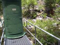
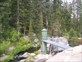
|   South Fork Rubicon 1143000 gauge station South Fork Rubicon 1143000 gauge station
in River Gauges South Fork Rubicon posted by:  TeamBlueHeeler TeamBlueHeeler location: California date approved: 06/15/2009 last visited: never |
 view gallery view gallery N9.2 km N9.2 km
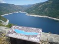
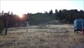
|  Hell Hole Reservoir Hell Hole Reservoir
in Geological Devilish Locations Hole Hole Resv. is in the Sierra Nevadas and serves as a water supply for Placer County, CA. posted by: Scoobert location: California date approved: 11/12/2005 last visited: 01/29/2015 |
 view gallery view gallery NE11.1 km NE11.1 km
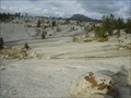
| Hell's Half Acre in Geological Devilish Locations Where else, near Hell Hole Reservoir. posted by: Scoobert location: California date approved: 11/12/2005 last visited: never |
 view gallery view gallery E11.4 km E11.4 km
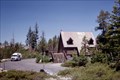
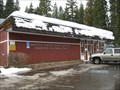
|  Loon Lake USFS Chalet -- El Dorado NF and County, CA Loon Lake USFS Chalet -- El Dorado NF and County, CA
in Chalet, Cottage, and Cabin Style Lodging At 6,000+ elev. this lake is preferred for fishing rather than swimming. The chalet is near the end of the paved road, but the center point of an area that is open to winter recreation (snow mobile sometimes). posted by:  sbcamper sbcamper location: California date approved: 03/21/2012 last visited: 07/19/2012 |
 view gallery view galleryE12.1 km | Loon Lake 11429500 Gauge Station in River Gauges Measuring the outflow from Loon Lake. posted by: TeamBlueHeeler location: California date approved: 06/15/2009 last visited: never |
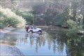 view gallery view galleryE12.2 km |  Rubicon Trail - El Dorado Co. California Rubicon Trail - El Dorado Co. California
in Offroad Trails Since the 1960's a favored jeep and 4WD trail that requires patience, driving skill, mechanical skill, and a skid plate. Seasonal use from June to September at 4,000 to 7,000 elevation. posted by: sbcamper location: California date approved: 10/09/2015 last visited: 10/15/2015 |
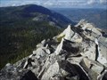
 view gallery view galleryE14.5 km | Devil's Peak in Geological Devilish Locations Devil's Peak, elevation 7525, is near the start of the Rubicon Trail, a famous 4x4 route. posted by: Scoobert location: California date approved: 11/12/2005 last visited: never |
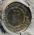
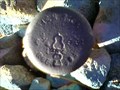 view gallery view gallerySE19.6 km |  RCE1984 RCE1984
in U.S. Benchmarks Top of small rise on the edge of the forest service land in El Dorado County posted by: bd_gun_dlr location: California date approved: 10/09/2007 last visited: never |
 view gallery view galleryNE23.2 km | Lake Tahoe- Twin Peaks in U.S. Benchmarks This benchmark is atop Twin Peaks on Lake Tahoe's West Shore- elevation 8,878'. posted by: DaisyDela location: California date approved: 10/26/2007 last visited: never |
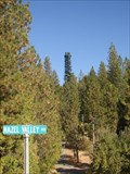
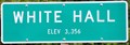 view gallery view gallery S24.8 km S24.8 km
|  White Hall, California (Western Approach) ~ Elevation 3356 Feet White Hall, California (Western Approach) ~ Elevation 3356 Feet
in Elevation Signs This Elevation Sign is located on the south side of US Highway 50 at the western town limit of White Hall, California. posted by: brwhiz location: California date approved: 02/10/2013 last visited: never |
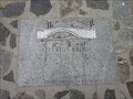
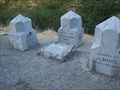
 view gallery view galleryS25.1 km |  Moore's (Riverton) Moore's (Riverton)
in California Historical Markers California Registered Historical Landmark #705 posted by: heringermr location: California date approved: 05/15/2007 last visited: 04/03/2015 |
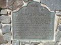 view gallery view galleryS25.1 km |  Moore's (Riverton) Moore's (Riverton)
in Pony Express Monuments California Registered Historical Landmark #705 posted by: heringermr location: California date approved: 05/07/2007 last visited: 04/03/2015 |
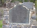 view gallery view galleryS25.1 km |  Moore’s (Riverton) - Riverton, CA Moore’s (Riverton) - Riverton, CA
in E Clampus Vitus Historical Markers An ECV and CA marker on Hway 50. posted by: saopaulo1 location: California date approved: 05/17/2011 last visited: 04/03/2015 |
 view gallery view galleryS25.1 km |  Riverton Bridge - Kyburz, CA Riverton Bridge - Kyburz, CA
in Signs of History The remains of a former bridge, located on Hway 50. posted by: saopaulo1 location: California date approved: 06/09/2011 last visited: 04/03/2015 |
 view gallery view galleryS25.1 km |  Echo Pass to Riverton - US HW 50, El Dorado Co. CA Echo Pass to Riverton - US HW 50, El Dorado Co. CA
in National Scenic Byways This stretch of Highway 50 is mostly two lanes (with a few passing lanes) along the south fork of the American River. posted by: sbcamper location: California date approved: 09/30/2014 last visited: 04/03/2015 |
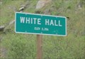 view gallery view galleryS25.3 km | White Hall, CA - 3356 Ft in Elevation Signs A sign at the entrance of White Hall on Hway 50. posted by: saopaulo1 location: California date approved: 06/06/2011 last visited: never |
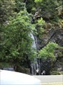 view gallery view galleryS25.7 km |  Bridal Veil Falls - Pollock Pines, CA. Bridal Veil Falls - Pollock Pines, CA.
in Waterfalls The Bridal Veil Falls in Pollock Pines, CA. posted by: saopaulo1 location: California date approved: 08/31/2018 last visited: never |
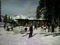 view gallery view galleryNE26.2 km |  The Chalet The Chalet
in Ski Lodges The Chalet at Alpine Meadows posted by: mappicus location: California date approved: 01/12/2007 last visited: 01/06/2007 |
 view gallery view galleryS26.6 km |  Cell tower near Pollock Pines, CA on Highway 50 Cell tower near Pollock Pines, CA on Highway 50
in Disguised Cell Towers Cell tower just Highway 50 near Pollock Pines, Ca. I had passed it many times before I noticed it was there. posted by: GGDCHIP location: California date approved: 10/31/2006 last visited: 10/31/2006 |
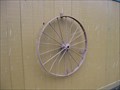 view gallery view galleryS27 km |  Gas Station Wagon Wheel - Fresh Pond, CA Gas Station Wagon Wheel - Fresh Pond, CA
in Wagon Wheels Wagon wheels decorate the side of this gas station on Hway 50. posted by: saopaulo1 location: California date approved: 01/08/2011 last visited: never |
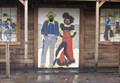 view gallery view galleryS27 km |  Saloon Cutout - Fresh Pond, CA Saloon Cutout - Fresh Pond, CA
in Photo Cutouts A cutout of a saloon scene at a Shell Station on Hway 50 in Fresh Pond, CA. posted by: saopaulo1 location: California date approved: 01/07/2011 last visited: never |
 view gallery view galleryE27.2 km |  Homewood Mountain Resort - Lake Tahoe, CA Homewood Mountain Resort - Lake Tahoe, CA
in Aerial Lifts There are numerous aerial lifts at this ski resort. posted by: NW_history_buff location: California date approved: 01/02/2017 last visited: never |
 view gallery view galleryE27.2 km |  Homewood Mountain Resort - Lake Tahoe, CA Homewood Mountain Resort - Lake Tahoe, CA
in Winter Sports Locations Homewood Mountain Resort contains numerous ski lifts from beginners through advanced skiers. posted by: NW_history_buff location: California date approved: 01/02/2017 last visited: never |
 view gallery view galleryE27.2 km |  Homewood, CA - 96141 Homewood, CA - 96141
in U.S. Post Offices A large post office in the small community of Homewood, CA. posted by: saopaulo1 location: California date approved: 01/10/2011 last visited: 11/22/2011 |
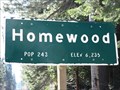 view gallery view galleryNE27.4 km | Homewood, CA (Northern Approach) - 6235' in Elevation Signs The sign is located at the north end of Homewood on Highway 89, west side of Lake Tahoe. posted by: WR7X location: California date approved: 04/01/2013 last visited: never |
|