 view gallery view gallery SW8 km SW8 km
|   T22S R21E S10 S11 S14 S15 - Grand County, Utah T22S R21E S10 S11 S14 S15 - Grand County, Utah
in Public Land Survey Marks A GLO section corner marker to the northeast of Yellow Cat Road in Sagers Flat. posted by:  Tom.dog Tom.dog location: Utah date approved: 06/11/2023 last visited: never |
 view gallery view gallerySW8.2 km |  DESERT NO 1 - Grand County, Utah DESERT NO 1 - Grand County, Utah
in U.S. Benchmarks Reference mark 1 for triangulation station DESERT. posted by: Tom.dog location: Utah date approved: 06/11/2023 last visited: never |
 view gallery view gallerySW8.2 km | DESERT (JM0556) - Grand County, Utah in U.S. Benchmarks This triangulation station is set on top of a small hill to the south of Sagers Flat. posted by: Tom.dog location: Utah date approved: 06/11/2023 last visited: never |
 view gallery view gallerySW8.2 km | DESERT NO 2 - Grand County, Utah in U.S. Benchmarks Reference mark 2 for triangulation station DESERT. posted by: Tom.dog location: Utah date approved: 06/11/2023 last visited: never |
 view gallery view gallerySW8.4 km | T22S R21E S14 S13 S24 S23 - Grand County, Utah in Public Land Survey Marks A GLO section corner to the south of Sagers Flat. posted by: Tom.dog location: Utah date approved: 06/11/2023 last visited: never |
 view gallery view gallerySW8.5 km |  DESERT Azimuth Mark - Grand County, Utah DESERT Azimuth Mark - Grand County, Utah
in Azimuth Benchmarks The azimuth mark for triangulation station DESERT (JM0556), located along a ridge in Sagers Flat. posted by: Tom.dog location: Utah date approved: 07/02/2023 last visited: never |
 view gallery view gallerySW8.5 km | DESERT Azimuth Mark - Grand County, Utah in U.S. Benchmarks The azimuth mark for triangulation station DESERT. posted by: Tom.dog location: Utah date approved: 06/11/2023 last visited: never |
 view gallery view gallerySW8.9 km | T22S R21E S14 S23 1/4 - Grand County, Utah in Public Land Survey Marks A GLO quarter corner marker on the south side of a low ridge in Sagers Flat. posted by: Tom.dog location: Utah date approved: 06/11/2023 last visited: never |
![Image for T22S R22E S31 S32 [T23S R22E S5] SC - Grand County, Utah](https://img.geocaching.com/waymarking/small/e629f1ad-80ee-46b6-bcef-1695e533533c.jpg) view gallery view gallery S12.2 km S12.2 km
| T22S R22E S31 S32 [T23S R22E S5] SC - Grand County, Utah in Public Land Survey Marks A GLO standard corner marker in the Thompsons uranium mining district. posted by: Tom.dog location: Utah date approved: 06/11/2023 last visited: never |
![Image for T22S R22E S31 [T23S R22E S6] 1/4 SC - Grand County, Utah](https://img.geocaching.com/waymarking/small/5e643af2-654e-47f0-aa2f-3710160e001d.jpg) view gallery view galleryS12.2 km | T22S R22E S31 [T23S R22E S6] 1/4 SC - Grand County, Utah in Public Land Survey Marks This GLO quarter standard corner marker is located in the Thompsons uranium mining district. posted by: Tom.dog location: Utah date approved: 06/11/2023 last visited: never |
![Image for T22S R21E S36 R22E S31 [T23S R22E S6] SC - Grand County, Utah](https://img.geocaching.com/waymarking/small/713ab596-7414-4756-8a3e-17fe4bfa2bf0.jpg) view gallery view galleryS12.4 km | T22S R21E S36 R22E S31 [T23S R22E S6] SC - Grand County, Utah in Public Land Survey Marks A GLO standard corner marker in the Thompsons uranium mining district. posted by: Tom.dog location: Utah date approved: 06/11/2023 last visited: never |
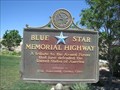 view gallery view gallery W15.4 km W15.4 km
|  I-70 West Thompson Rest Area - Thompson, Utah I-70 West Thompson Rest Area - Thompson, Utah
in Blue Star Memorial Highway Markers Blue Star Memorial marker in rest area and welcome center off I-70 west bound near Thompson, Utah. posted by:  BruceS BruceS location: Utah date approved: 06/28/2011 last visited: 01/03/2023 |
 view gallery view galleryW15.4 km |  Welcome to Utah ~ "Life Elevated" Welcome to Utah ~ "Life Elevated"
in Welcome Signs This Welcome sign is in the Thompson Rest Area and Welcome Center on the north side of Interstate Highway 70 at milepost 188, about one mile east of Thompson, Utah. posted by: brwhiz location: Utah date approved: 12/06/2012 last visited: 01/03/2023 |
 view gallery view galleryW15.4 km |  Thompson Rest Area and Welcome Center Thompson Rest Area and Welcome Center
in Highway Rest Areas The Thompson Rest Area and Welcome Center is located on the north side of Interstate Highway 70 at milepost 188, about one mile east of Thompson, Utah. posted by: brwhiz location: Utah date approved: 12/06/2012 last visited: 01/03/2023 |
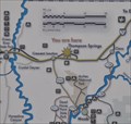 view gallery view galleryW15.4 km |  Thompson Springs, Utah Thompson Springs, Utah
in 'You Are Here' Maps You Are Here in Thompson Springs, Utah on the Dinosaur Diamond Scenic Byway. posted by: brwhiz location: Utah date approved: 09/05/2012 last visited: 01/03/2023 |
 view gallery view galleryW15.4 km |  Thompson Welcome Center Guest Register Thompson Welcome Center Guest Register
in Guest Books This Guest Book is in the Thompson Welcome Center at the Thompson Rest Area on the north side of Interstate Highway 70 at milepost 188, about one mile east of Thompson, Utah. posted by: brwhiz location: Utah date approved: 12/06/2012 last visited: never |
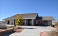
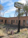
 view gallery view galleryW15.4 km |  Thompson Welcome Center Thompson Welcome Center
in Tourist Information Centers - Visitor Centers The Thompson Welcome Center is in the Thompson Rest Area located on the north side of Interstate Highway 70 at milepost 188, about one mile east of Thompson, Utah. posted by: brwhiz location: Utah date approved: 12/09/2012 last visited: 01/03/2023 |
 view gallery view gallery E16.4 km E16.4 km
|  Cisco, Utah 84515 Cisco, Utah 84515
in U.S. Post Offices in a semi-abandoned town in Eastern Utah. posted by:  sherpes sherpes location: Utah date approved: 12/22/2009 last visited: 11/08/2017 |
 view gallery view galleryE16.4 km |  Cisco, Utah Cisco, Utah
in Wikipedia Entries Cisco is a ghost town in Utah near the junction of State Route 128 and Interstate 70.... posted by: JacobBarlow location: Utah date approved: 08/28/2007 last visited: 11/09/2019 |
 view gallery view galleryE16.4 km |  Cisco Mural Cisco Mural
in Murals This Mural is painted on the front of an old building in old Cisco, Utah. posted by: JacobBarlow location: Utah date approved: 08/28/2007 last visited: 07/14/2013 |
 view gallery view galleryE16.4 km |  Cisco, Utah Cisco, Utah
in Ghost Towns Cisco is a ghost town in Utah near the junction of State Route 128
and Interstate 70.... posted by: JacobBarlow location: Utah date approved: 08/28/2007 last visited: 11/09/2019 |
 view gallery view galleryW17.9 km | S 15 (JM0281) - Thompson Springs, UT in U.S. Benchmarks This U.S. Coast and Geodetic Survey Benchmark Disk is stamped with the elevation - in Thompson Springs, Utah. posted by: The Snowdog location: Utah date approved: 01/03/2023 last visited: 12/24/2023 |
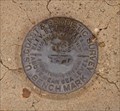 view gallery view galleryW17.9 km |  5145.259 Feet - Thompson Springs, UT 5145.259 Feet - Thompson Springs, UT
in Elevation Signs This U.S. Coast and Geodetic Survey Benchmark Disk gives the elevation - to a thousandth of a foot - in Thompson Springs, Utah. posted by: The Snowdog location: Utah date approved: 01/02/2023 last visited: never |
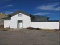 view gallery view galleryW18 km |  Thompson School - Thompson, Utah Thompson School - Thompson, Utah
in Former Schools Former school in what is nearly a former town. posted by: linkys location: Utah date approved: 05/08/2011 last visited: 10/19/2011 |
 view gallery view galleryW18.2 km | Thompson Springs, Utah in Wikipedia Entries A place that time and the Interstate highway has passed by. posted by: linkys location: Utah date approved: 05/09/2011 last visited: 10/19/2011 |
|