 view gallery view gallery NW2.1 km NW2.1 km
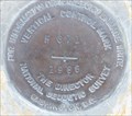
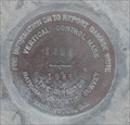
|   NGS Benchmark JE1605 - Johnson County, Ks NGS Benchmark JE1605 - Johnson County, Ks
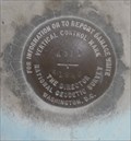
in U.S. Benchmarks This vertical control mark is located on a K-10 bridge pier at Edgerton Rd, west side. posted by:  iconions iconions location: Kansas date approved: 12/23/2008 last visited: never |
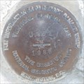 view gallery view gallery NE2.4 km NE2.4 km
| NGS Benchmark JE1607 - De Soto, Ks in U.S. Benchmarks This disk is located in a K-10 bridge pier on Lexington Ave. in DeSoto, Ks. posted by: iconions location: Kansas date approved: 12/23/2008 last visited: never |
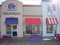
 view gallery view galleryNE2.6 km |  KFC - W 91st St- DeSoto, Ks KFC - W 91st St- DeSoto, Ks
in Kentucky Fried Chicken/KFC Restaurants This is a KFC/Taco Bell combo off of K-10 Hwy in DeSoto, Kansas. posted by: iconions location: Kansas date approved: 01/10/2008 last visited: never |
 view gallery view galleryNE2.6 km |  Taco Bell - W 91st St - De Soto, Kansas Taco Bell - W 91st St - De Soto, Kansas
in Taco Bell Restaurants This is the Taco Bell / KFC combo restaurant near K-10 HWY in DeSoto Kansas. posted by: iconions location: Kansas date approved: 01/10/2008 last visited: never |
 view gallery view galleryNE2.9 km |  In Memory of our Hero Dead of World War II - DeSoto, Ks In Memory of our Hero Dead of World War II - DeSoto, Ks
in World War II Memorials / Monuments This memorial is located at the newer southern end of the DeSoto Cemetery - 34500 W 87th St posted by: iconions location: Kansas date approved: 01/18/2010 last visited: never |
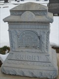 view gallery view galleryNE2.9 km |  J. H. Knight - DeSoto Cemetery - DeSoto, Ks. J. H. Knight - DeSoto Cemetery - DeSoto, Ks.
in Zinc Headstones This zinc make is located in the middle of the DeSoto Cemetery - 34500 W 87th St. posted by: iconions location: Kansas date approved: 01/22/2010 last visited: never |
 view gallery view gallery W3.1 km W3.1 km
| NGS Benchmark JE1604 - Johnson County, Ks in U.S. Benchmarks This is a Vertical control Mark set into a bridge pier on K-10 over Evening Star Road. posted by: iconions location: Kansas date approved: 12/19/2008 last visited: never |
 view gallery view gallery N3.1 km N3.1 km
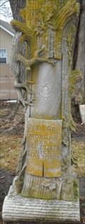
|  Morgan - De Soto Cemetery - De Soto, Ks Morgan - De Soto Cemetery - De Soto, Ks
in Woodmen of the World Grave Markers/Monuments This "stump" style marker is locted near the west entrance of the De Soto Cemetery - 34339-34525 W 87th St in DeSoto, Ks. posted by: iconions location: Kansas date approved: 01/17/2010 last visited: 05/06/2010 |
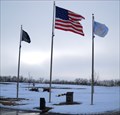
 view gallery view galleryNE4 km |  USS Neosho AO-143 Partners in Patriotism USS Neosho AO-143 Partners in Patriotism
in Maritime Monuments and Memorials USS Neosho (AO-143) was the lead ship of the Neosho-class oilers (1954) transferred to US Military Sealift Command in 1978 and stricken in 1994. posted by:  EcoTrekUSA EcoTrekUSA location: Kansas date approved: 07/10/2014 last visited: 07/07/2014 |
 view gallery view galleryW5 km | NGS Benchmark JE1603 - Douglas County, Ks in U.S. Benchmarks This is a vertical control mark set into a pier supporting another K-10 bridge - this time over E2400th RD. The Geocaching.com database incorrectly lists this mark in Johnson County. posted by: iconions location: Kansas date approved: 12/20/2008 last visited: never |
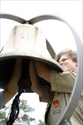
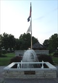 view gallery view galleryNE5.1 km |  Miller Memorial Park Fountain Miller Memorial Park Fountain
in Fountains Fountain in Miller Memorial Park in De Soto, KS. posted by: wardnkathy location: Kansas date approved: 07/31/2009 last visited: never |
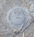
 view gallery view gallery SW6 km SW6 km
| JCPW Benchmark 721 - near DeSoto, Ks in U.S. Benchmarks This Johnson County Public Works Benchmark is located 3 tenths of a mile east of 127th & Evening Star Road. posted by: iconions location: Kansas date approved: 02/25/2009 last visited: never |
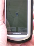 view gallery view galleryN6 km |  N39 W95 Confluence - Bonner Springs, Kansas N39 W95 Confluence - Bonner Springs, Kansas
in Confluence Spots Just outside a corn field. posted by: gparkes location: Kansas date approved: 12/29/2008 last visited: never |
 view gallery view galleryW6.1 km | NGS Benchmark JE1602 - Douglas County, Ks. in U.S. Benchmarks This vertical control mark is in a pier supporting a bridge of K-10 with N1400 Rd running underneath. posted by: iconions location: Kansas date approved: 12/20/2008 last visited: never |
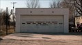 view gallery view galleryNW6.8 km |  Sherman Township Fire Department - Linwood, Kansas Sherman Township Fire Department - Linwood, Kansas
in Firehouses This location serves all of Sherman township from it's location in Linwood, Kansas. posted by: Bear and LAM location: Kansas date approved: 09/23/2008 last visited: 04/06/2008 |
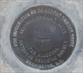
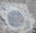
 view gallery view gallerySW6.9 km | JCPW Benchmark 720 - near DeSoto, Ks in U.S. Benchmarks This Johnson County Public Works Benchmark is the vertical control for BM-1069 nearby which is the Horizontal Control. This Benchmark is located 7 tenths of a mile south of 127th and Evening Star Rd. posted by: iconions location: Kansas date approved: 02/25/2009 last visited: never |
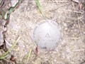 view gallery view gallerySW7.1 km | JCPW-1069 in U.S. Benchmarks Johnson County Public Works Benchmark posted by: larry739 location: Kansas date approved: 11/16/2008 last visited: 04/02/2012 |
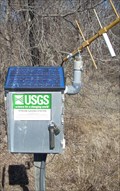 view gallery view gallery E7.1 km E7.1 km
|  Camp Creek Solar Powered River Gauge - near DeSoto, Ks Camp Creek Solar Powered River Gauge - near DeSoto, Ks
in Solar Power This solar powered USGS gauge is located on the east side of the Camp Creek Bridge on 95th Street in rural Johnson County, Kansas, near De Soto.
posted by: iconions location: Kansas date approved: 02/16/2009 last visited: never |
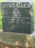 view gallery view galleryW7.4 km | George P. Lentz - Eudora City Cemetery - Eudora, Ks. in Woodmen of the World Grave Markers/Monuments This grey granite slab headstone is located on N1420 Road just east of Eudora, Ks. posted by: iconions location: Kansas date approved: 08/18/2013 last visited: never |
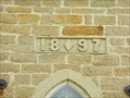 view gallery view galleryW8 km |  1897 - Old Holy Family Church - Eudora, Ks. 1897 - Old Holy Family Church - Eudora, Ks.
in Dated Buildings and Cornerstones This former Catholic Church - now used for special occasions and Christmas Carol program. It is located at 911 W. 9th in Eudora, Ks. posted by: iconions location: Kansas date approved: 08/18/2013 last visited: never |
 view gallery view galleryW8 km |  Old Holy Family Church - Eudora, Kansas Old Holy Family Church - Eudora, Kansas
in Victorian Style Architecture This former Catholic Church - now used for special occasions and Christmas Carol program. posted by: iconions location: Kansas date approved: 07/04/2019 last visited: never |
 view gallery view galleryW8 km |  Old Holy Family Catholic Church - Eudora, Kansas Old Holy Family Catholic Church - Eudora, Kansas
in This Old Church This historic Church building is used by the Parish for Special Events and for Christmas Programs. It is located at 911 W. 9th in Eudora, Kansas. posted by: iconions location: Kansas date approved: 08/19/2013 last visited: never |
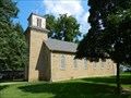 view gallery view galleryW8 km | Old Holy Family Church - Eudora, Ks. in Roman Catholic Churches This former Catholic Church - now used for special occasions and Christmas Carol program. posted by: iconions location: Kansas date approved: 08/19/2013 last visited: never |
 view gallery view galleryW8.2 km |  700 Main Street - Eudora, Ks. 700 Main Street - Eudora, Ks.
in Kansas Historical Markers This two-story red brick building is located at 700 Main Street in Eudora, Ks. posted by: iconions location: Kansas date approved: 04/03/2015 last visited: never |
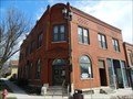 view gallery view galleryW8.2 km |  Kaw Valley Bank - Eudora, Ks. Kaw Valley Bank - Eudora, Ks.
in Converted Bank Buildings This two-story red brick Richardson Romanesque building is located at 700 Main Street in Eudora, Ks. posted by: iconions location: Kansas date approved: 04/06/2015 last visited: never |
|