 view gallery view gallery NE0.5 km NE0.5 km
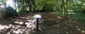
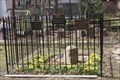
|   7 - William Watters Gravesite - McLean, VA 7 - William Watters Gravesite - McLean, VA
in Historic United Methodist Sites William Watters was the first Methodist minister who was a native of North America. This marker is located at the site of his grave in McLean, Virginia. posted by:  Hikenutty Hikenutty location: Virginia date approved: 06/24/2008 last visited: 06/25/2017 |
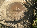
 view gallery view gallery S2.1 km S2.1 km
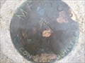
|  Beacon Hill (HV8335) - Falls church, VA Beacon Hill (HV8335) - Falls church, VA
in U.S. Benchmarks survey disk in sidewalk in front of Beacon Hill neighborhood of Falls Church posted by:  hrothroc hrothroc location: Virginia date approved: 11/03/2022 last visited: 11/02/2022 |
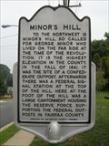 view gallery view galleryS2.4 km |  Minor's Hill Minor's Hill
in Virginia Historical Markers Minor's Hill was the site of a Confederate outpost early in the Civil War, and later housed a Union signal station. posted by: macdonr location: Virginia date approved: 08/30/2006 last visited: 09/10/2006 |
 view gallery view gallery W2.4 km W2.4 km
|  Church of Christ Scientist - McLean, Virginia Church of Christ Scientist - McLean, Virginia
in Church of Christ Scientist Located along Chain Bridge Road in Mclean. posted by: flyingmoose location: Virginia date approved: 10/29/2020 last visited: never |
 view gallery view gallery SE2.4 km SE2.4 km
|  Little Falls Presbyterian Church - Arlington, Virginia Little Falls Presbyterian Church - Arlington, Virginia
in Outdoor Altars An outdoor section of the church in the wooded lot next to the rear parking lot. posted by: flyingmoose location: Virginia date approved: 02/09/2021 last visited: never |
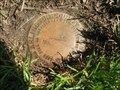
 view gallery view gallery E2.6 km E2.6 km
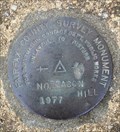
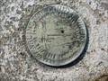
| PHRA8 in U.S. Benchmarks PHRA8 is an Arlington County geodetic control disk.
posted by: Black Dog Trackers location: Virginia date approved: 04/29/2006 last visited: 08/21/2016 |
 view gallery view galleryS2.6 km | PHRA19 in U.S. Benchmarks PHRA19 in Arlington, Virginia posted by: Black Dog Trackers location: Virginia date approved: 04/29/2006 last visited: never |
 view gallery view gallerySE2.6 km |  Little Falls Presbyterian Church - Arlington, Virginia Little Falls Presbyterian Church - Arlington, Virginia
in Presbyterian Churches Church is located in northern Arlington, ample parking when church is not in session. posted by: flyingmoose location: Virginia date approved: 07/28/2020 last visited: never |
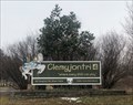 view gallery view gallery N2.7 km N2.7 km
|  Clemyjontri Park Clemyjontri Park
in Accessible-Designed Recreational Locations Located on the eastern end of Georgetown Pike before it intersects with Dolly Madison Boulevard. posted by: flyingmoose location: Virginia date approved: 02/18/2021 last visited: never |
 view gallery view gallerySE2.7 km | BN31 in U.S. Benchmarks BN31 in Arlington, Virginia posted by: Black Dog Trackers location: Virginia date approved: 04/29/2006 last visited: 08/21/2016 |
 view gallery view galleryE2.7 km | PHRA7 in U.S. Benchmarks Station PHRA7 in Arlington Virginia. posted by: Black Dog Trackers location: Virginia date approved: 04/29/2006 last visited: 08/21/2016 |
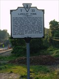 view gallery view galleryN2.9 km | Langley Fork in Virginia Historical Markers Located along the westbound side of route 193/ Georgetown pike. There is ample parking along the road, even in traffic. There is also a sports park along the same road with the name Langley fork that is primarily a soccer field. posted by: flyingmoose location: Virginia date approved: 05/26/2006 last visited: 01/22/2022 |
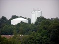 view gallery view galleryW3.1 km |  McLean Duo at Dulles Toll road and 123 McLean Duo at Dulles Toll road and 123
in Water Towers A brother and sister water tower photo, taken from Capital One Drive parking lot and 123 in McLean, Va. posted by: DoUW4W location: Virginia date approved: 07/23/2008 last visited: never |
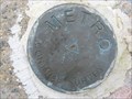
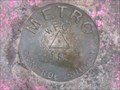 view gallery view gallery SW3.1 km SW3.1 km
| METRO WFC-1R, Virginia in U.S. Benchmarks METRO WFC-1R, VA, is a survey disk mounted in a sidewalk near a bus stop at the West Falls Church METRO station in Fairfax County, VA. posted by: seventhings location: Virginia date approved: 01/09/2006 last visited: never |
 view gallery view gallerySW3.1 km | METRO WFC-2, Virginia in U.S. Benchmarks METRO WFC-2, VA, is a survey disk mounted in a sidewalk near the bus-only lane entrance to the West Falls Church METRO station in Fairfax County, VA. posted by: seventhings location: Virginia date approved: 01/09/2006 last visited: never |
 view gallery view gallerySE3.2 km |  Arlington Co. 2006 Champ Kentucky Coffeetree Arlington Co. 2006 Champ Kentucky Coffeetree
in Exceptional Trees Kentucky Coffeetree at Chestnut Hills Park. Non-native posted by: Lost Geographers location: Virginia date approved: 07/29/2007 last visited: 08/07/2016 |
 view gallery view gallerySW3.2 km | METRO DX-171, Virginia in U.S. Benchmarks METRO DX-171, VA, is a survey disk mounted in the top of a concrete wall near an outdoor parking lot near the West Falls Church METRO station in Fairfax County, VA. posted by: seventhings location: Virginia date approved: 01/09/2006 last visited: never |
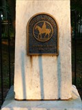
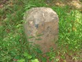 view gallery view galleryS3.2 km |  Washington DC Boundary Stone - West Washington DC Boundary Stone - West
in U.S. Historic Survey Stones and Monuments Washington DC Boundary Stone - West
This is the west cornerstone of the series of Washington DC boundary markers established in 1791 and 1792 to establish the boundaries of the District of Columbia. posted by: Black Dog Trackers location: Virginia date approved: 10/21/2006 last visited: 06/14/2020 |
 view gallery view galleryS3.2 km |  DC West Boundary Cornerstone DAR Plaques -- Falls Church, VA, USA DC West Boundary Cornerstone DAR Plaques -- Falls Church, VA, USA
in Daughters of the American Revolution FOUR separate DAR plaques at the west boundary cornerstone for the Federal District of Columbia, at the border with Falls Church VA posted by: Benchmark Blasterz location: District of Columbia date approved: 05/19/2023 last visited: 05/04/2023 |
 view gallery view gallerySW3.2 km | METRO WFC-8, Virginia in U.S. Benchmarks METRO WFC-8, VA, is a survey disk mounted in a sidewalk on an overpass of an exit lane from Interstate Highway 66 near the West Falls Church METRO station in Fairfax County, VA. posted by: seventhings location: Virginia date approved: 01/09/2006 last visited: never |
 view gallery view galleryE3.2 km | BN1 in U.S. Benchmarks BN1 in Arlington, Virginia posted by: Black Dog Trackers location: Virginia date approved: 04/29/2006 last visited: 08/07/2016 |
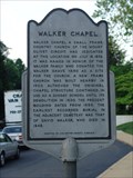 view gallery view galleryE3.2 km | Walker Chapel in Virginia Historical Markers Right along the northbound side of Glebe road inbetween route 29 and the chain bridge. Parking is good here. posted by: flyingmoose location: Virginia date approved: 05/26/2006 last visited: 06/19/2016 |
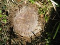
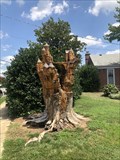 view gallery view galleryS3.4 km |  The Fairy Kingdom's Castle - Arlington, Virginia The Fairy Kingdom's Castle - Arlington, Virginia
in Outside Wooden Display Carvings Nicely carved tree stump along the sidewalk. posted by: flyingmoose location: Virginia date approved: 07/27/2020 last visited: never |
 view gallery view gallerySE3.5 km | PHRA15 in U.S. Benchmarks PHRA15 in Arlington, Virginia posted by: Black Dog Trackers location: Virginia date approved: 12/03/2005 last visited: 08/21/2016 |
 SE3.7 km |  Sushi-Zen Sushi-Zen
in Sushi Restaurants An excellent sushi restaurant and sushi bar in Arlington Virginia. posted by: Black Dog Trackers location: Virginia date approved: 10/22/2005 last visited: 08/07/2016 |
|