 view gallery view gallery N1.6 km N1.6 km
|   Aiton Elementary School Traffic Garden - Washington, D.C Aiton Elementary School Traffic Garden - Washington, D.C
in Traffic Parks A traffic garden located on the paved surfaces of Aiton Elementary School. posted by:  flyingmoose flyingmoose location: District of Columbia date approved: 04/05/2021 last visited: 05/21/2023 |
 view gallery view gallery W1.8 km W1.8 km
|  Fort Dupont - Washington DC Fort Dupont - Washington DC
in U.S. Civil War Sites Fort Dupont was an earthwork fort built in 1861 as part of the Civil War Defenses of Washington, completed in spring 1862, and in use till 1865 when it was abandoned. posted by:  Don.Morfe Don.Morfe location: District of Columbia date approved: 03/18/2022 last visited: 03/18/2022 |
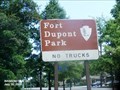
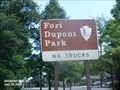 view gallery view galleryW1.8 km | ") Fort Dupont Park - Washington DC Fort Dupont Park - Washington DC
in National Parks (U.S.) Fort Dupont was commenced between October and December of 1861 and "completed" in the spring on 1862. It was named for Flag Officer Samuel F. Dupont, who commanded the naval victory at Port Royal, South Carolina, in November 1861. posted by: Don.Morfe location: District of Columbia date approved: 01/17/2020 last visited: 10/28/2021 |
 view gallery view galleryW1.8 km |  Fort Dupont Park - Washington DC Fort Dupont Park - Washington DC
in National Parks of the World Fort Dupont Park is a 376-acre wooded park under the management of the National Park Service located in Washington, DC. The name of the park comes from the old Civil War earthwork fort that lies within the park. posted by: Don.Morfe location: District of Columbia date approved: 03/17/2022 last visited: 03/18/2022 |
 view gallery view galleryW1.8 km |  Fort Dupont Park - Washington DC Fort Dupont Park - Washington DC
in Official Local Tourism Attractions Fort Dupont Park is a 376-acre wooded park under the management of the National Park Service located in Washington, DC. The name of the park comes from the old Civil War earthwork fort that lies within the park. posted by: Don.Morfe location: District of Columbia date approved: 03/18/2022 last visited: 03/18/2022 |
 view gallery view galleryW1.8 km |  Fort Dupont - Washington DC Fort Dupont - Washington DC
in Military Installations Fort Dupont was an earthwork fort built in 1861 as part of the Civil War Defenses of Washington, completed in spring 1862, and in use until 1865 when it was abandoned. posted by: Don.Morfe location: District of Columbia date approved: 03/18/2022 last visited: 03/18/2022 |
 view gallery view galleryW1.8 km |  Fort Dupont Park - Washington DC Fort Dupont Park - Washington DC
in NPS Passport Cancellation Stations Fort Dupont was commenced between October and December of 1861, and "completed" in the spring of 1862. Like most of the older works it underwent some modifications between 1861 and 1865. posted by: Don.Morfe location: District of Columbia date approved: 01/20/2020 last visited: 10/10/2021 |
 view gallery view galleryW1.8 km |  Fort Dupont Park - Washington DC Fort Dupont Park - Washington DC
in Wikipedia Entries Fort Dupont Park is a 376-acre wooded park under the management of the National Park Service located in Washington, DC. The name of the park comes from the old Civil War earthwork fort that lies within the park. posted by: Don.Morfe location: District of Columbia date approved: 03/17/2022 last visited: 03/18/2022 |
 view gallery view galleryN1.9 km |  Lederer Youth Garden - Washington, D.C. Lederer Youth Garden - Washington, D.C.
in Children's Gardens Located along Nannie Helen Burroughs Avenue and Marvin Gaye Park. posted by: flyingmoose location: District of Columbia date approved: 10/06/2020 last visited: never |
 view gallery view gallery NW2.1 km NW2.1 km
|  Washington, DC 20019 ~ River Terrace Carrier Annex Washington, DC 20019 ~ River Terrace Carrier Annex
in U.S. Post Offices This is one of many post offices in the city. posted by: bluesnote location: District of Columbia date approved: 03/22/2014 last visited: 03/22/2014 |
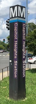 view gallery view gallery NE2.1 km NE2.1 km
|  Capitol Heights Station - Capitol Heights, Maryland Capitol Heights Station - Capitol Heights, Maryland
in The Underground Located at the Eastern Tip of Washington, D.C. at the intersection of East Capitol Street and Southern Avenue. posted by: flyingmoose location: Maryland date approved: 07/01/2021 last visited: never |
 view gallery view galleryNE2.1 km |  East Capitol St. - Capitol Heights, MD / Washington, DC East Capitol St. - Capitol Heights, MD / Washington, DC
in Border Crossings A border crossing along Capitol Street when it changes from jurisdictions from Maryland to the District of Columbia. posted by: bluesnote location: District of Columbia date approved: 01/09/2018 last visited: 01/09/2018 |
 view gallery view galleryN2.3 km |  Marvin Gaye - Washington, D.C. Marvin Gaye - Washington, D.C.
in Mosaics Located at the eastern entrance to the Marvin Gaye Park. posted by: flyingmoose location: District of Columbia date approved: 07/04/2021 last visited: never |
 view gallery view galleryNE2.4 km |  Marvin Gaye - Washington, D.C. Marvin Gaye - Washington, D.C.
in Musician Statues A statue of Marvin Gaye in Grant Park posted by: flyingmoose location: District of Columbia date approved: 07/28/2024 last visited: never |
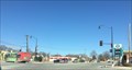 view gallery view galleryNE2.6 km | Martin Luther King Jr. Highway - Seat Pleasant, MD / Washington, DC in Border Crossings A border crossing along Martin Luther King Jr. Highway when it changes from jurisdictions from Maryland to the District of Columbia. posted by: bluesnote location: District of Columbia date approved: 01/09/2018 last visited: 01/09/2018 |
 view gallery view gallery E2.6 km E2.6 km
|  Maryland Park Bicycles - Capitol Heights, MD Maryland Park Bicycles - Capitol Heights, MD
in Bicycle Shops A bike shop in Capitol Heights, Maryland. posted by: bluesnote location: Maryland date approved: 01/09/2018 last visited: 01/09/2018 |
 view gallery view galleryNE2.6 km |  DC East Cornerstone - Washington, DC, USA DC East Cornerstone - Washington, DC, USA
in Daughters of the American Revolution The eastern boundary stone, marking the eastern edge of the 10 x 10 mile diamond of the District of Columbia. This stone, set in 1791, still stands and continues to mark the official boarder between Washington, DC and Maryland. posted by: bluesnote location: District of Columbia date approved: 05/04/2023 last visited: never |
 view gallery view galleryNE2.6 km |  DC East Cornerstone - Washington, DC DC East Cornerstone - Washington, DC
in U.S. Historic Survey Stones and Monuments The eastern boundary stone, marking the eastern edge of the 10 x 10 mile diamond of the District of Columbia. This stone, set in 1791, still stands and continues to mark the official boarder between Washington, DC and Maryland. posted by: bluesnote location: District of Columbia date approved: 01/15/2018 last visited: 01/15/2018 |
 view gallery view galleryNE2.6 km | DC East Cornerstone - Washington, DC in Border Crossings The eastern boundary stone, marking the eastern edge of the 10 x 10 mile diamond of the District of Columbia. This stone, set in 1791, still stands and continues to mark the official boarder between Washington, DC and Maryland. posted by: bluesnote location: District of Columbia date approved: 01/06/2018 last visited: 01/06/2018 |
 view gallery view galleryNE2.6 km |  DC East Cornerstone - Washington, DC DC East Cornerstone - Washington, DC
in U.S. Benchmarks The eastern boundary stone, marking the eastern edge of the 10 x 10 mile diamond of the District of Columbia. This stone, set in 1791, still stands and continues to mark the official boarder between Washington, DC and Maryland. posted by: bluesnote location: District of Columbia date approved: 01/06/2018 last visited: 01/06/2018 |
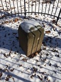 view gallery view galleryNE2.6 km |  DC East Cornerstone - Washington, DC DC East Cornerstone - Washington, DC
in U.S. National Register of Historic Places The eastern boundary stone, marking the eastern edge of the 10 x 10 mile diamond of the District of Columbia. This stone, set in 1791, still stands and continues to mark the official boarder between Washington, DC and Maryland. posted by: bluesnote location: District of Columbia date approved: 01/07/2018 last visited: 01/07/2018 |
 view gallery view galleryNE2.6 km |  EASTERNMOST -- Point in DC - Washington, DC EASTERNMOST -- Point in DC - Washington, DC
in Superlatives The eastern boundary stone, marking the eastern edge of the 10 x 10 mile diamond of the District of Columbia. This stone, set in 1791, still stands and continues to mark the official boarder between Washington, DC and Maryland. posted by: bluesnote location: District of Columbia date approved: 01/06/2018 last visited: 01/06/2018 |
 view gallery view galleryNE2.6 km |  DC East Cornerstone - Washington, DC DC East Cornerstone - Washington, DC
in Public Land Survey Marks The eastern boundary stone, marking the eastern edge of the 10 x 10 mile diamond of the District of Columbia. This stone, set in 1791, still stands and continues to mark the official boarder between Washington, DC and Maryland. posted by: bluesnote location: District of Columbia date approved: 01/06/2018 last visited: 01/06/2018 |
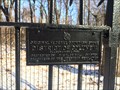 view gallery view galleryNE2.6 km |  DC East Cornerstone - 1791 - Washington, DC DC East Cornerstone - 1791 - Washington, DC
in Dated Architectural Structures Multifarious The eastern boundary stone, marking the eastern edge of the 10 x 10 mile diamond of the District of Columbia. This stone, set in 1791, still stands and continues to mark the official boarder between Washington, DC and Maryland. posted by: bluesnote location: District of Columbia date approved: 01/07/2018 last visited: 01/07/2018 |
 view gallery view galleryNE2.6 km |  DC East Cornerstone - Washington, DC DC East Cornerstone - Washington, DC
in Tripoints and Multipoints The eastern boundary stone, marking the eastern edge of the 10 x 10 mile diamond of the District of Columbia. This stone, set in 1791, still stands and continues to mark the official boarder between Washington, DC and Maryland. posted by: bluesnote location: District of Columbia date approved: 01/07/2018 last visited: 01/07/2018 |
|