 view gallery view gallery S3.1 km S3.1 km
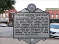
|   Pfost-Green Murders / Last Public Execution Pfost-Green Murders / Last Public Execution
in West Virginia Historical Markers Tells about the murder of Chloe Green and two of her three children and the public execution of their murderer. posted by:  Paintedwarrior Paintedwarrior location: West Virginia date approved: 08/23/2016 last visited: 12/24/2018 |
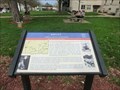
 view gallery view galleryS3.1 km |  Partisan Raid-Ripley Post Office - Ripley WV Partisan Raid-Ripley Post Office - Ripley WV
in U.S. Civil War Sites Marker is in Ripley, West Virginia, in Jackson County at the intersection of Court Street North and West Main Street (U.S. 33)
on the grounds of the Jackson County Courthouse, Ripley WV 25271 posted by:  Don.Morfe Don.Morfe location: West Virginia date approved: 07/12/2023 last visited: 07/12/2023 |
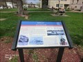
 view gallery view galleryS3.1 km | Partisan Raid-Ripley Post Office - Ripley WV in Civil War Discovery Trail Sites During the Civil War, both Union and Confederate supporters formed guerrilla bands. Each government denounced the other side’s partisans as bushwhackers or common thieves but gave those on their own side an official military designation as cover. posted by: Don.Morfe location: West Virginia date approved: 08/31/2020 last visited: 10/04/2021 |
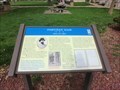
 view gallery view galleryS3.1 km | Ripley-Jackson County Courthouse - Ripley WV in Civil War Discovery Trail Sites Jackson County was created by an act of the Virginia Assembly on March 1, 1831, and named in honor of President Andrew Jackson.
The first courthouse on this site was a brick structure. posted by: Don.Morfe location: West Virginia date approved: 08/31/2020 last visited: 10/04/2021 |
 view gallery view galleryS3.1 km | Ripley-Jackson County Court House - Ripley WV in U.S. Civil War Sites Marker is in Ripley, West Virginia, in Jackson County on North Court Street just north of West Main Street (U.S. 33), at 106 N Court St, Ripley WV 25271. posted by: Don.Morfe location: West Virginia date approved: 07/12/2023 last visited: 07/12/2023 |
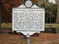
 view gallery view galleryS3.1 km | Ripley-McGrew / Hood Grist Mill - Ripley WV in Civil War Discovery Trail Sites In 1824 Jacob Sturdier built the first grist mill in Ripley along Mill Creek. In 1853, Jacob Sayre sold the mill to John McGrew who came to Jackson County in 1844. posted by: Don.Morfe location: West Virginia date approved: 08/31/2020 last visited: 10/04/2021 |
 view gallery view galleryS3.1 km | Ripley McGrew / Hood Grist Mill - Ripley WV in U.S. Civil War Sites Marker is in Ripley, West Virginia, in Jackson County on Court Street north of Main Street (U.S. 33), at the courthouse. posted by: Don.Morfe location: West Virginia date approved: 07/12/2023 last visited: 07/12/2023 |
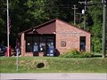
 view gallery view galleryS3.1 km |  Ripley WV 25271 Post Office Ripley WV 25271 Post Office
in U.S. Post Offices Ripley WV 25271 Post Office posted by: dukemartin location: West Virginia date approved: 08/22/2016 last visited: never |
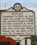 view gallery view galleryS3.2 km | Ripley in West Virginia Historical Markers Ripley established in 1832 posted by: two-bit Joe location: West Virginia date approved: 10/27/2006 last visited: 08/20/2016 |
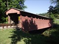
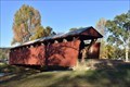 view gallery view galleryS5.8 km |  Staats Mill Covered Bridge - Jackson County, West Virginia Staats Mill Covered Bridge - Jackson County, West Virginia
in Covered Bridges Staats Mill Covered Bridge(48-18-04) is located at Cedar Lake State Conference Center. It was moved here in 1983 from its original site over Tug Fork of Mill Creek. posted by: buffalohiker location: West Virginia date approved: 10/30/2019 last visited: 01/30/2024 |
 view gallery view galleryS5.8 km | Staats Mill Covered Bridge in West Virginia Historical Markers Built in 1887 over Tug Fork of Mill Creek and named for Enoch Staats' posted by: two-bit Joe location: West Virginia date approved: 11/06/2006 last visited: 01/30/2024 |
 view gallery view galleryS5.8 km | The Casto Hole-Serving Opposite Side - Ripley WV in U.S. Civil War Sites Marker is in Ripley, West Virginia, in Jackson County on FFA Drive east of Cedar Creek Drive (County Route 25), at 82 FFA Drive, Ripley WV 25271. posted by: Don.Morfe location: West Virginia date approved: 07/12/2023 last visited: 07/12/2023 |
 view gallery view galleryS5.8 km | The Casto Hole-Serving Opposite Sides - Ripley WV in Civil War Discovery Trail Sites Although western Virginia eventually separated from the original state to form West Virginia and join the Union, many residents of the new state supported the Confederacy. posted by: Don.Morfe location: West Virginia date approved: 08/31/2020 last visited: 10/04/2021 |
 view gallery view gallery W7.6 km W7.6 km
|  Mail Pouch barn - MPB 48-18-09 Mail Pouch barn - MPB 48-18-09
in Barns MPB 48-18-09 outside of Ripley, WV. posted by: Wallyum location: West Virginia date approved: 03/24/2021 last visited: 09/17/2015 |
 view gallery view gallery NE7.7 km NE7.7 km
| Sandyville, West Virginia - 25275 in U.S. Post Offices Sandyville Post Office is located in the small town of Sandyville, West Virginia. posted by: deano1943 location: West Virginia date approved: 07/09/2010 last visited: 07/09/2010 |
 view gallery view galleryS9.2 km |  7-Eleven - Ripley, WV 7-Eleven - Ripley, WV
in 7-Eleven Stores 7-Eleven in Ripley, WV posted by: uccacher location: West Virginia date approved: 08/20/2011 last visited: 03/13/2013 |
 view gallery view galleryNE9.7 km | Sarvis Fork Covered Bridge - Jackson Co., WV in Covered Bridges Sarvis Fork Covered Bridge is located in Jackson County, West Virginia. posted by: deano1943 location: West Virginia date approved: 07/13/2010 last visited: 10/24/2019 |
 view gallery view galleryNE9.7 km |  Sarvis Fork Covered Bridge - Jackson County, West Virginia Sarvis Fork Covered Bridge - Jackson County, West Virginia
in U.S. National Register of Historic Places Sarvis Fork Covered Bridge is located in Jackson County, West Virginia. posted by: deano1943 location: West Virginia date approved: 07/09/2010 last visited: 10/24/2019 |
 view gallery view gallery NW10.1 km NW10.1 km
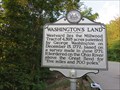
| Washington's Land in West Virginia Historical Markers A sign telling us about land Washington owned. posted by: Paintedwarrior location: West Virginia date approved: 08/23/2016 last visited: 11/27/2020 |
 view gallery view galleryW10.6 km | Cottageville WV Post Office - 26239 in U.S. Post Offices This post office is located at 53 Ole Mill Rd in Cottageville, WV which is in Jackson County. posted by: VQ9JC location: West Virginia date approved: 08/25/2013 last visited: 08/20/2016 |
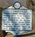 view gallery view galleryW10.9 km | Cottageville in West Virginia Historical Markers Cottageville Jackson County, WV posted by: two-bit Joe location: West Virginia date approved: 02/05/2007 last visited: 06/12/2005 |
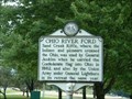 view gallery view galleryNW12.1 km | Ohio River Ford/Ravenswood in West Virginia Historical Markers Where the Indians and pioneers crossed the Ohio.
These lands were surveyed, 1771, for George Washington posted by: two-bit Joe location: West Virginia date approved: 10/30/2006 last visited: 08/20/2016 |
 view gallery view galleryNW13 km | Millwood WV 25262 Post Office in U.S. Post Offices Millwood WV 25262 Post Office posted by: dukemartin location: West Virginia date approved: 08/22/2016 last visited: never |
 view gallery view gallery SE13.4 km SE13.4 km
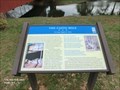
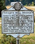
| Staats Mill Bridge in West Virginia Historical Markers Raised in 1867 by order of Jackson County Court posted by: two-bit Joe location: West Virginia date approved: 11/06/2006 last visited: 07/06/2022 |
 view gallery view galleryNW13.8 km | Ravenswood WV 26164 Post Office in U.S. Post Offices Ravenswood WV 26164 Post Office posted by: dukemartin location: West Virginia date approved: 08/22/2016 last visited: never |
|