 view gallery view gallery NW10.5 km NW10.5 km
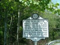
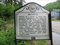
|   French Creek French Creek
in West Virginia Historical Markers Settled by colonists posted by:  two-bit Joe two-bit Joe location: West Virginia date approved: 03/26/2011 last visited: 06/28/2013 |
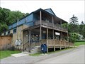
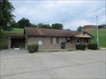 view gallery view galleryNW10.6 km |  French Creek WV 26218 Post Office French Creek WV 26218 Post Office
in U.S. Post Offices French Creek WV Post Office posted by:  dukemartin dukemartin location: West Virginia date approved: 06/12/2018 last visited: never |
 view gallery view gallery N10.6 km N10.6 km
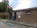
| Tallmansville WV 26237 Post Office in U.S. Post Offices Tallmansville WV Post Office posted by: dukemartin location: West Virginia date approved: 10/04/2019 last visited: never |
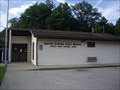 view gallery view galleryNW10.9 km | Adrian WV 26210 Post Office in U.S. Post Offices Adrian WV 26210 Post Office posted by: dukemartin location: West Virginia date approved: 07/02/2013 last visited: never |
 view gallery view gallery W11.1 km W11.1 km
|  Raid in Upshur County - Cleveland WV Raid in Upshur County - Cleveland WV
in Battlefields While at drill here on Sept. 12, 1863, a company of 70 Upshur County militia under Daniel Gould was captured by a force of Confederates under Major J. K. Kesler. Seven escaped, 25 paroled, and 38 died in captivity. posted by: Don.Morfe location: West Virginia date approved: 11/21/2020 last visited: 10/16/2021 |
 view gallery view galleryW11.1 km |  Kesler's Raid Capture of Upshur County Militia - Cleveland WV Kesler's Raid Capture of Upshur County Militia - Cleveland WV
in U.S. Civil War Sites Marker is in Cleveland, West Virginia, in Upshur County. Marker is at the intersection of Ireland - Rock Cave Road (State Highway 20) and Flatwood Run Road (County Route 20/13) on Ireland - Rock Cave Road.
Cleveland WV 26215 posted by: Don.Morfe location: West Virginia date approved: 07/07/2023 last visited: 07/07/2023 |
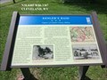
 view gallery view galleryW11.1 km | Kesler's Raid-Capture of Upshur County Militia - Cleveland WV in Civil War Discovery Trail Sites In September 1863, Confederate Maj. Joseph K. Kesler, 19th Virginia Cavalry, led a raid from Pocahontas County through Upshur County and Centerville (present-day Rock Cave). posted by: Don.Morfe location: West Virginia date approved: 08/17/2020 last visited: 10/04/2021 |
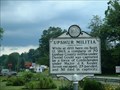 view gallery view galleryW11.1 km | Upshur Militia in West Virginia Historical Markers Upshur County militia posted by: two-bit Joe location: West Virginia date approved: 03/26/2011 last visited: 03/22/2023 |
 view gallery view galleryW11.1 km |  Upshur Militia - Rock Cave WV Upshur Militia - Rock Cave WV
in Specific Veteran Memorials While at drill here on Sept. 12, 1863, a company of 70 Upshur County militia under Daniel Gould was captured by a force of Confederates under Major J. K. Kesler. posted by: Don.Morfe location: West Virginia date approved: 03/24/2023 last visited: 03/22/2023 |
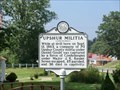 view gallery view galleryW11.1 km | Upshur Militia - Rock Cave WV in American Civil War Monuments and Memorials Marker is located on Ireland Rock Cave Road, Rock Cave WV. posted by: Don.Morfe location: West Virginia date approved: 09/02/2023 last visited: 09/02/2023 |
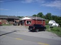 view gallery view galleryW11.3 km | Rock Cave WV 26234 Post Office in U.S. Post Offices Rock Cave WV 26234 Post Office posted by: dukemartin location: West Virginia date approved: 07/25/2013 last visited: never |
 view gallery view gallery S12.6 km S12.6 km
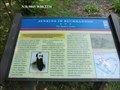
| Helvetia in West Virginia Historical Markers A sign describing the many skills the immigrants brought to this town. posted by: dukemartin location: West Virginia date approved: 06/05/2018 last visited: 06/05/2018 |
 view gallery view galleryS12.7 km | Helevetia WV 26224 Post Office in U.S. Post Offices Helevetia WV Post Office posted by: dukemartin location: West Virginia date approved: 06/12/2018 last visited: never |
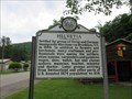 view gallery view galleryS12.9 km | Helvetia in West Virginia Historical Markers A sign describing the many skills the immigrants brought to this town. posted by: dukemartin location: West Virginia date approved: 06/05/2018 last visited: 06/05/2018 |
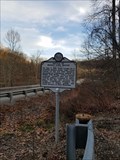 view gallery view gallery NE15.4 km NE15.4 km
| Battle Of Middle Fork Bridge in West Virginia Historical Markers Historical Marker describing the Battle of Middle Fork Bridge, which took place just days before the near-by Battle of Rich Mountain. Holding this bridge gave an advantage to the Union troops at Rich Mt. posted by: wv-yen location: West Virginia date approved: 08/06/2020 last visited: 12/11/2020 |
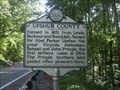
 view gallery view galleryNE15.4 km | Randolph County / Upshur County in West Virginia Historical Markers A two sided sign telling us from where the two counties were formed. posted by: Paintedwarrior location: West Virginia date approved: 02/08/2016 last visited: 02/09/2016 |
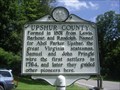
 view gallery view galleryW15.8 km | Upshur / Lewis County in West Virginia Historical Markers A two sided sign telling us when and from where the two counties were formed. posted by: Paintedwarrior location: West Virginia date approved: 07/28/2013 last visited: 08/01/2013 |
 view gallery view gallery SW18 km SW18 km
| Upshur / Webster County in West Virginia Historical Markers A two sided sign telling us when and from where the two counties where formed. posted by: Paintedwarrior location: West Virginia date approved: 07/28/2013 last visited: 08/01/2013 |
 view gallery view galleryN18.3 km | Jenkins in Buckhannon-The Raiders Strike - Buckhannon WV in U.S. Civil War Sites Confederate Gen. Albert G. Jenkins and his cavalry halted a few miles east of Buckhannon on the Staunton and Parkersburg Turnpike on August 30, 1862. He knew that an immense quantity of Union supplies and several thousand small arms were stockpiled. posted by: Don.Morfe location: West Virginia date approved: 07/05/2023 last visited: 07/05/2023 |
 view gallery view galleryN18.3 km | Battle Hill - Buckhannon WV in Battlefields When the defenders marched to Battle Hill (present-day Water Tank Hill, in front of you) to entrench on August 30, they were surprised to find the Confederates already there. The Federals quickly threw up breastworks of rails, logs, and straw stacks nearby posted by: Don.Morfe location: West Virginia date approved: 11/21/2020 last visited: 10/16/2021 |
 view gallery view galleryN18.3 km | Jenkins in Buckhannon-The Raiders Strike - Buckhannon WV in Civil War Discovery Trail Sites Confederate Gen. Albert G. Jenkins and his cavalry halted a few miles east of Buckhannon on the Staunton and Parkersburg Turnpike on August 30, 1862. posted by: Don.Morfe location: West Virginia date approved: 08/14/2020 last visited: 10/05/2021 |
 view gallery view galleryN18.7 km | McClellan's Buckhannon Camp Prelude to Rich Mountain - Buckhannon WV in Civil War Discovery Trail Sites In one of the first important Union victories of the Civil War, on July 11, 1861, Union Gen. George B. McClellan’s forces defeated part of Confederate Gen. Robert S Garnett’s command east of here at Rich Mountain. posted by: Don.Morfe location: West Virginia date approved: 08/14/2020 last visited: 10/05/2021 |
 view gallery view galleryN18.7 km | McClellan's Buckhannon Camp-Prelude to Rich Mountain - Buckhannon WV in U.S. Civil War Sites In one of the first important Union victories of the Civil War, on July 11, 1861, Union Gen. George B. McClellan’s forces defeated part of Confederate Gen. Robert S Garnett’s command east of here at Rich Mountain. posted by: Don.Morfe location: West Virginia date approved: 07/05/2023 last visited: 07/05/2023 |
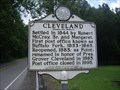 view gallery view gallerySW18.7 km | Cleveland in West Virginia Historical Markers A sign with the same information on both sides telling us when the area was settled and how it received its name. posted by: Paintedwarrior location: West Virginia date approved: 07/28/2013 last visited: 08/01/2013 |
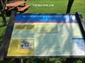
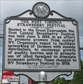 view gallery view galleryN19.2 km | The West Virginia Strawberry Festival in West Virginia Historical Markers The first Central Strawberry Festival. posted by: dukemartin location: West Virginia date approved: 08/28/2020 last visited: never |
|