 view gallery view gallery SE3.4 km SE3.4 km
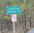
|   Hway 50 - 5,000 Ft - Kyburz, CA Hway 50 - 5,000 Ft - Kyburz, CA
in Elevation Signs An elevation marker on Hway 50 by Kyburz, CA. posted by:  saopaulo1 saopaulo1 location: California date approved: 06/07/2011 last visited: never |
 view gallery view gallery SW3.7 km SW3.7 km
|  Kyburz, CA - Pop: 139 Kyburz, CA - Pop: 139
in Population Signs A population sign in Kyburz, CA. posted by: saopaulo1 location: California date approved: 06/06/2011 last visited: 01/05/1988 |
 view gallery view gallerySW3.7 km |  Kyburz, CA - 95720 Kyburz, CA - 95720
in U.S. Post Offices A post office on Hway 50 in Kyburz, CA. posted by: saopaulo1 location: California date approved: 01/10/2011 last visited: 11/22/2011 |
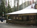
 view gallery view gallerySW5.1 km |  Webster's Sugar Loaf House Webster's Sugar Loaf House
in Pony Express Monuments California Registered Historical Landmark #706 posted by:  heringermr heringermr location: California date approved: 05/11/2007 last visited: 09/23/2009 |
 view gallery view gallerySW5.1 km |  Webster's Sugar Loaf House Webster's Sugar Loaf House
in California Historical Markers Pony Express Remount Station posted by: heringermr location: California date approved: 05/15/2007 last visited: never |
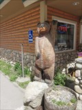 view gallery view gallerySW5.3 km |  Silver Fork Gas Station Bear - Silverfork, CA Silver Fork Gas Station Bear - Silverfork, CA
in Bear Statues A wooden bear outside a gas station on Hway 50 in Silverfork, CA. posted by: saopaulo1 location: California date approved: 05/17/2011 last visited: never |
 view gallery view gallerySW5.3 km |  Silver Fork Gas Station Bear - Silverfork, CA Silver Fork Gas Station Bear - Silverfork, CA
in Outside Wooden Display Carvings A bear in front of a gas station in Silverfork, CA posted by: saopaulo1 location: California date approved: 05/17/2011 last visited: never |
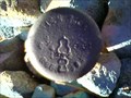 view gallery view gallery NW7.7 km NW7.7 km
|  RCE1984 RCE1984
in U.S. Benchmarks Top of small rise on the edge of the forest service land in El Dorado County posted by: bd_gun_dlr location: California date approved: 10/09/2007 last visited: never |
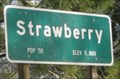 view gallery view gallery E10.5 km E10.5 km
| Strawberry, CA - 5,800 Ft in Elevation Signs An elevation sign for the community of Strawberry, CA. posted by: saopaulo1 location: California date approved: 01/14/2011 last visited: never |
 view gallery view galleryE10.5 km | Strawberry Valley House in California Historical Markers California Registered Historical Landmark #707 posted by: heringermr location: California date approved: 05/15/2007 last visited: never |
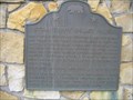 view gallery view galleryE10.5 km | Strawberry Valley House in Pony Express Monuments California Registered Historical Landmark #707 posted by: heringermr location: California date approved: 05/12/2007 last visited: 09/23/2009 |
 view gallery view galleryE10.6 km | Twin Bridges, CA - 95735 in U.S. Post Offices The post office for Twin Bridges in next to the Strawberry Market and Deli on Hway 50. posted by: saopaulo1 location: California date approved: 03/31/2010 last visited: 11/27/2011 |
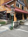 view gallery view galleryE10.6 km |  Strawberry Station General Store Directional Arrows - Strawberry, CA Strawberry Station General Store Directional Arrows - Strawberry, CA
in Direction and Distance Arrows Directional arrows in front of the Strawberry Station Store. posted by: saopaulo1 location: California date approved: 09/17/2018 last visited: never |
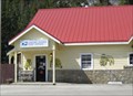
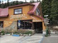 view gallery view galleryE10.6 km |  Strawberry Station General Store - Strawberry, CA Strawberry Station General Store - Strawberry, CA
in The Local Neighborhood Grocer Strawberry Station General Store is located in Strawberry, CA. posted by: saopaulo1 location: California date approved: 09/09/2018 last visited: never |
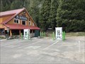 view gallery view galleryE10.6 km |  Strawberry Station General Store Chargers - Strawberry, CA Strawberry Station General Store Chargers - Strawberry, CA
in Electric Car Charging Stations A charger in front of the Strawberry Station General store in Strawberry, CA. posted by: saopaulo1 location: California date approved: 08/31/2018 last visited: never |
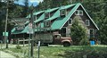 view gallery view galleryE10.6 km |  Strawberry Lodge - Strawberry, CA Strawberry Lodge - Strawberry, CA
in Lodge-Style Accommodations The Strawberry Lodge in Strawberry, CA. posted by: saopaulo1 location: California date approved: 08/31/2018 last visited: never |
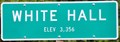
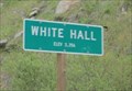 view gallery view gallery W11.3 km W11.3 km
| White Hall, CA - 3356 Ft in Elevation Signs A sign at the entrance of White Hall on Hway 50. posted by: saopaulo1 location: California date approved: 06/06/2011 last visited: never |
 view gallery view gallery S12.1 km S12.1 km
|  Hell's Delight Valley Hell's Delight Valley
in Geological Devilish Locations Hells Delight Creek flows into the Silver Fork of the American River in El Dorado County, California. posted by: Scoobert location: California date approved: 11/12/2005 last visited: never |
 view gallery view galleryW12.4 km | White Hall, California (Western Approach) ~ Elevation 3356 Feet in Elevation Signs This Elevation Sign is located on the south side of US Highway 50 at the western town limit of White Hall, California. posted by: brwhiz location: California date approved: 02/10/2013 last visited: never |
 view gallery view galleryE12.6 km |  Horsetail Falls - El Dorado Co. CA Horsetail Falls - El Dorado Co. CA
in Hiking and walking trailheads Horsetail Falls, aka Pyramid Creek Trail, is a day hike with elevation gain from 6,120 feet to 6,880 feet. Right, about 1/2 mile vertical climb on granite, boulders, and trail in the manzanita. posted by: sbcamper location: California date approved: 10/01/2014 last visited: 10/09/2014 |
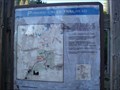
 view gallery view galleryE12.7 km |  You Are Here - Pyramid Creek Trail - El Dorado Co CA You Are Here - Pyramid Creek Trail - El Dorado Co CA
in 'You Are Here' Maps Beginning of a 1.5 mile vertical climb to view the waterfall of Pyramid Creek. posted by: sbcamper location: California date approved: 09/28/2014 last visited: never |
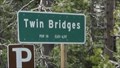 view gallery view galleryE12.9 km | Twin Bridges, CA - Pop: 10 in Population Signs A sign on Hway 50 as you enter Twin Bridges, CA. posted by: saopaulo1 location: California date approved: 06/06/2011 last visited: never |
 view gallery view galleryE12.9 km | Twin Bridges, CA - 6117 Ft in Elevation Signs A sign on Hway 50 as you enter Twin Bridges, CA. posted by: saopaulo1 location: California date approved: 06/06/2011 last visited: never |
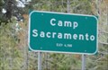 view gallery view galleryE13.2 km | Camp Sacramento, CA - 6500 Ft in Elevation Signs A sign at the entrance of Camp Sacramento, CA. The community is located in El Dorado County on Hway 50. posted by: saopaulo1 location: California date approved: 06/06/2011 last visited: never |
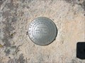 view gallery view gallerySW14.3 km | Silver Lake Road - 21LC - 1948 in U.S. Benchmarks Benchmark is located along the Mormon Emigrant Trail in the El Dorado Nat'l Forest posted by: Marcie/Eric location: California date approved: 06/22/2009 last visited: never |
|