 view gallery view gallery W0.2 km W0.2 km
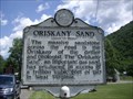
|   Oriskany Sand Oriskany Sand
in West Virginia Historical Markers Tells about nearby sandstone producing gas. posted by:  Paintedwarrior Paintedwarrior location: West Virginia date approved: 07/07/2012 last visited: 07/14/2012 |
 view gallery view gallery N0.2 km N0.2 km
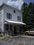
|  Riverton, WV 26814 Riverton, WV 26814
in U.S. Post Offices Riverton WV 26814, Post Office posted by: dukemartin location: West Virginia date approved: 06/06/2012 last visited: never |
 view gallery view gallery SE0.3 km SE0.3 km
|  The "Battle" of Riverton - Riverton WV The "Battle" of Riverton - Riverton WV
in American Civil War Monuments and Memorials Marker is on Germany Valley Road (County Route 9) in Riverton, West Virginia, in Pendleton County. posted by:  Don.Morfe Don.Morfe location: West Virginia date approved: 07/30/2023 last visited: 07/30/2023 |
 view gallery view gallerySE0.3 km |  The "Battle" of Riverton - Riverton WV The "Battle" of Riverton - Riverton WV
in Signs of History Marker is on Germany Valley Road (County Route 9) in Riverton, West Virginia, in Pendleton County. posted by: Don.Morfe location: West Virginia date approved: 07/25/2023 last visited: 07/25/2023 |
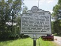
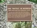 view gallery view gallerySE0.3 km |  FIRST - Union Raid into Pendleton-Battle of Riverton WV FIRST - Union Raid into Pendleton-Battle of Riverton WV
in First of its Kind The "Battle" of Riverton-First Union Raid into Pendleton County At this site on March 2nd, 1862, Union forces numbering forty were attacked by local Confederate infantry and two units of cavalry. posted by: Don.Morfe location: West Virginia date approved: 04/02/2023 last visited: 04/02/2023 |
 view gallery view gallerySE0.3 km | Battle of Riverton - Riverton WV in U.S. Civil War Sites The "Battle" of Riverton-First Union Raid into Pendleton County At this site on March 2nd, 1862, Union forces numbering forty were attacked by local Confederate infantry and two units of cavalry. posted by: Don.Morfe location: West Virginia date approved: 04/03/2023 last visited: 04/02/2023 |
 view gallery view gallerySE0.3 km |  Battle of Riverton - Riverton WV Battle of Riverton - Riverton WV
in Battlefields The "Battle" of Riverton-First Union Raid into Pendleton County
At this site on March 2nd, 1862, Union forces numbering forty were attacked by local Confederate infantry and two units of cavalry. posted by: Don.Morfe location: West Virginia date approved: 04/01/2023 last visited: 04/02/2023 |
 view gallery view gallery E1.6 km E1.6 km
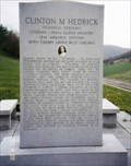
|  Clinton M. Hedrick-Riverton, WV Clinton M. Hedrick-Riverton, WV
in Medal Of Honor Resting Places World War II Medal of Honor Recipient for action near Lembeck, Germany on March 27-28, 1945. He was killed in action. He is buried in North Fork Memorial Cemetery, Riverton WV. posted by: Don.Morfe location: West Virginia date approved: 11/16/2017 last visited: 12/19/2021 |
 view gallery view gallery S3.9 km S3.9 km
|  Solomon's Chapel United Brethren Church ~ Riverton, WV Solomon's Chapel United Brethren Church ~ Riverton, WV
in Country Churches Located near Riverton West Virginia. posted by: MNSearchers location: West Virginia date approved: 09/08/2008 last visited: never |
 view gallery view gallerySE4.2 km | Gravesite of John Dolly in West Virginia Historical Markers A short history of John Dolly, nearby Dolly Sods named after him. posted by: dukemartin location: West Virginia date approved: 08/14/2019 last visited: never |
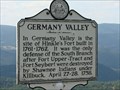 view gallery view gallerySE4.5 km | Germany Valley in West Virginia Historical Markers Located on Highway 33. posted by: MNSearchers location: West Virginia date approved: 09/11/2008 last visited: 04/02/2023 |
 view gallery view gallerySE4.5 km |  Germany Valley - Riverton WV Germany Valley - Riverton WV
in Wikipedia Entries Germany Valley is a scenic upland valley high in the Allegheny Mountains of eastern West Virginia originally settled by German (including Pennsylvania Dutch) farmers in the mid-18th century. posted by: Don.Morfe location: West Virginia date approved: 04/01/2023 last visited: 04/02/2023 |
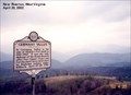
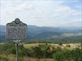 view gallery view gallerySE4.5 km |  Germany Valley Karst Area Germany Valley Karst Area
in U.S. National Natural Landmarks Germany Valley is a scenic upland valley high in the Allegheny Mountains of eastern West Virginia originally settled by German (including Pennsylvania Dutch) farmers in the mid-18th Century. posted by: MNSearchers location: West Virginia date approved: 09/01/2008 last visited: 11/18/2018 |
 view gallery view gallery SW4.8 km SW4.8 km
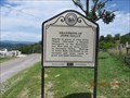
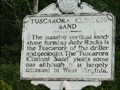
| Tuscarora (Clinton) Sand in West Virginia Historical Markers Located on highway 28. posted by: MNSearchers location: West Virginia date approved: 09/11/2008 last visited: 06/03/2012 |
 view gallery view gallerySW4.8 km | Birthplace of Rivers in West Virginia Historical Markers Located on highway 28 between Riverton and Circleville. posted by: MNSearchers location: West Virginia date approved: 09/11/2008 last visited: 06/04/2012 |
 view gallery view gallerySW4.8 km | Pocahontas County in West Virginia Historical Markers Located on highway 28 between Riverton and Circleville. posted by: MNSearchers location: West Virginia date approved: 09/11/2008 last visited: 06/04/2012 |
 view gallery view gallerySW5 km |  Judy Gap - WV Judy Gap - WV
in Your Name Here An Unincorporated town in Pendleton Co. WV posted by: wv-yen location: West Virginia date approved: 08/16/2021 last visited: never |
 view gallery view gallerySE5.1 km | Last Union Raid End of the War in Pendleton County - Riverton WV in U.S. Civil War Sites Marker is near Riverton, West Virginia, in Pendleton County. Marker is on U.S. 33. Franklin WV 26807 posted by: Don.Morfe location: West Virginia date approved: 07/07/2023 last visited: 07/07/2023 |
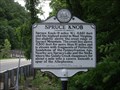 view gallery view gallerySW8.2 km | Spruce Knob in West Virginia Historical Markers Tells us about the area around the highest point in West Virginia. posted by: Paintedwarrior location: West Virginia date approved: 07/07/2012 last visited: 07/14/2012 |
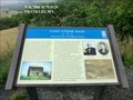
 view gallery view gallery NE9.2 km NE9.2 km
| Camp Luther in West Virginia Historical Markers A short history of a nearby church building used during the Civil War. posted by: dukemartin location: West Virginia date approved: 08/14/2019 last visited: never |
 view gallery view gallerySW9.3 km | Circleville, WV 26804 in U.S. Post Offices Circleville WV 26804 Post Office posted by: dukemartin location: West Virginia date approved: 06/06/2012 last visited: never |
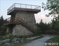 view gallery view gallerySW9.5 km |  Spruce Knob Observation Tower - Monongahela National Forest - Whitmer, West Virginia Spruce Knob Observation Tower - Monongahela National Forest - Whitmer, West Virginia
in Public Access Lands The Spruce Knob Observation Tower is located at the summit of Spruce Knob, the highest point of West Virginia at 4,863 Feet above sea level. This area is part of the Monongahela National Forest and is located in Pendleton County, West Virginia posted by: outdoorboy34 location: West Virginia date approved: 07/01/2012 last visited: 05/28/2023 |
 view gallery view gallerySW9.7 km |  Highest Point of West Virginia (Spruce Knob) Highest Point of West Virginia (Spruce Knob)
in Geographic High Points Relatively easy to access High Point nestled in the Spruce Knob-Seneca Rocks National Recreation Area. posted by: Ernmark location: West Virginia date approved: 06/24/2022 last visited: 05/28/2023 |
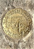 view gallery view gallerySW9.7 km |  Spruce (HW3569) - Pendleton County, WV Spruce (HW3569) - Pendleton County, WV
in U.S. Benchmarks USGS disk located at the summit of the highest mountain in West Virginia. posted by: Ernmark location: West Virginia date approved: 08/02/2022 last visited: never |
 view gallery view gallerySW9.8 km |  Spuce Knob Observation Tower - Monongahela National Forest - Whitmer, West Virginia Spuce Knob Observation Tower - Monongahela National Forest - Whitmer, West Virginia
in Look-Out Towers The observation tower for the highest point in West Virginia (Spruce Knob), is located within the Monongahela National Forest in Pendleton County, West Virginia posted by: outdoorboy34 location: West Virginia date approved: 06/30/2012 last visited: 08/01/2015 |
|