 view gallery view gallery NW6.4 km NW6.4 km
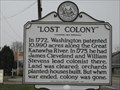
|   Lost Colony, West Virginia Lost Colony, West Virginia
in Ghost Towns One of the first Ghost Towns in the United States. posted by:  Crystal Sound Crystal Sound location: West Virginia date approved: 01/18/2007 last visited: 08/21/2017 |
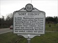 view gallery view galleryNW6.4 km |  Lost Colony Lost Colony
in West Virginia Historical Markers Historic Marker along US-35. posted by: Crystal Sound location: West Virginia date approved: 01/19/2007 last visited: 08/21/2017 |
 view gallery view gallery S6.6 km S6.6 km
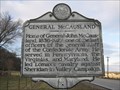
| General McCausland's Home in West Virginia Historical Markers Confederate Army General's house along US-35. posted by: Crystal Sound location: West Virginia date approved: 01/23/2007 last visited: 08/22/2017 |
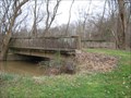
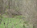 view gallery view galleryS6.6 km |  General McCausland Bridge General McCausland Bridge
in Orphaned Bridges Orphaned Bridge on the General McCausland Farm, along US 35 posted by: Crystal Sound location: West Virginia date approved: 05/08/2007 last visited: never |
 view gallery view galleryNW6.8 km | Beech Hill Church / US 35 Bridge in Orphaned Bridges Abandoned Bridge along US-35 and the Beech Hill United Methodist Church. posted by: Crystal Sound location: West Virginia date approved: 01/18/2007 last visited: never |
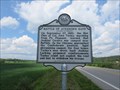 view gallery view galleryS8.2 km | Battle of Atkeson's Gate in West Virginia Historical Markers Describes a four hour battle that occurred here in 1862. posted by: dukemartin location: West Virginia date approved: 08/22/2017 last visited: 08/22/2017 |
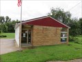
 view gallery view galleryS10.9 km |  Buffalo WV 25033 Post Office Buffalo WV 25033 Post Office
in U.S. Post Offices Buffalo WV Post Office posted by: dukemartin location: West Virginia date approved: 08/24/2017 last visited: never |
 view gallery view galleryS11.1 km | Buffalo Academy in West Virginia Historical Markers Tells about the short history of the school until the civil war. posted by: dukemartin location: West Virginia date approved: 08/22/2017 last visited: 08/22/2017 |
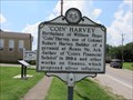 view gallery view galleryS11.1 km | "Coin" Harvey / "Lawnvale" in West Virginia Historical Markers A two side sign telling us about William Hope Harvey and Dr. T.C. Atkeson posted by: dukemartin location: West Virginia date approved: 08/22/2017 last visited: 08/22/2017 |
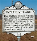 view gallery view galleryS14.6 km | Indian Village/Excavations in West Virginia Historical Markers Indian Village/Excavations Putnam Co., WV posted by:  two-bit Joe two-bit Joe location: West Virginia date approved: 02/24/2007 last visited: 08/21/2017 |
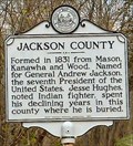 view gallery view gallery N16.6 km N16.6 km
| Jackson County/Mason County in West Virginia Historical Markers Formed in 1831 from Kanawha, Mason, and Wood. Named for General Andrew Jackson posted by: two-bit Joe location: West Virginia date approved: 10/31/2006 last visited: 08/20/2016 |
 view gallery view gallery W18.3 km W18.3 km
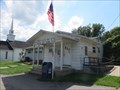
| Apple Grove WV 25502 Post Office in U.S. Post Offices Apple Grove WV Post Office posted by: dukemartin location: West Virginia date approved: 08/24/2017 last visited: never |
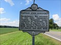 view gallery view gallery SW18.5 km SW18.5 km
| Captain John Hereford / Mercer's Bottom in West Virginia Historical Markers A two sided sign telling about two officers in the Revolutionary Army. posted by: dukemartin location: West Virginia date approved: 08/22/2017 last visited: 08/22/2017 |
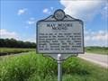 view gallery view galleryW18.7 km | May Moore Mound in West Virginia Historical Markers A quick statement about burial mounds in the area constructed by the Adena people. posted by: dukemartin location: West Virginia date approved: 08/22/2017 last visited: 08/22/2017 |
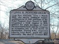 view gallery view galleryNW18.8 km | Livia S. Poffenbarger in West Virginia Historical Markers Livia S. Poffenbarger near Pt. Pleasant, WV posted by: two-bit Joe location: West Virginia date approved: 02/04/2007 last visited: 05/27/2018 |
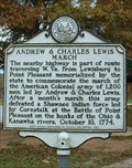 view gallery view galleryNW18.8 km | Andrew & Charles Lewis March in West Virginia Historical Markers Point Pleasant (Andrew & Charles Lewis March) posted by: two-bit Joe location: West Virginia date approved: 02/02/2007 last visited: 08/29/2023 |
 view gallery view galleryNW18.8 km |  Fort Randolph - Point Pleasant, WV Fort Randolph - Point Pleasant, WV
in Satellite Imagery Oddities A replica of Fort Randolph has been built about a mile from the original in Point Pleasant, West Virginia. posted by: bobfrapples8 location: West Virginia date approved: 10/09/2023 last visited: never |
 view gallery view galleryS19.2 km |  Earth Home - Winfield, West Virginia Earth Home - Winfield, West Virginia
in Earth Homes This earth home is on the west side of Highway 817 in Winfield, West Virginia, USA. posted by: Marine Biologist location: West Virginia date approved: 11/25/2007 last visited: 02/20/2008 |
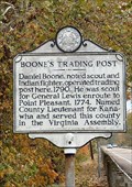 view gallery view galleryNW19.5 km | Boone's Trading Post in West Virginia Historical Markers Boone's Trading Post posted by: two-bit Joe location: West Virginia date approved: 02/26/2007 last visited: 08/29/2023 |
 view gallery view galleryN19.6 km | Letart WV 25253 Post Office in U.S. Post Offices Letart WV 25253 Post Office posted by: dukemartin location: West Virginia date approved: 08/22/2016 last visited: never |
 view gallery view gallerySW19.6 km | Ashton WV 25503 Post Office in U.S. Post Offices Ashton WV Post Office posted by: dukemartin location: West Virginia date approved: 08/24/2017 last visited: never |
 view gallery view galleryNW19.8 km | Henderson WV 25106 Post Office in U.S. Post Offices Henderson WV Post Office posted by: dukemartin location: West Virginia date approved: 08/24/2017 last visited: 08/29/2023 |
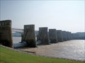 view gallery view galleryW19.8 km |  Robert C. Byrd Locks & Dam - Gallipolis, OH Robert C. Byrd Locks & Dam - Gallipolis, OH
in Water Dams Coordinates are taken at the Abutment Access area on the Ohio side of this dam, near Gallipolis, Ohio. It was put into operation in 1937 with major upgrades in 1992, used primarily for barge navigation, but also hydroelctric production & recreation. posted by: silverquill location: Ohio date approved: 02/04/2009 last visited: never |
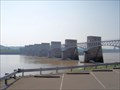 view gallery view galleryW19.8 km |  Robert C. Byrd Locks & Dam - Gallipolis, OH Robert C. Byrd Locks & Dam - Gallipolis, OH
in People-Named Places First built in 1937, this dam spanning the Ohio River from West Virginia to Ohio is named for West Virginia Sen.Robert C. Bird, longest serving member of the U.S. Senate. Coordinates Abutment Access area on the Ohio side, near Gallipolis, Ohio. posted by: silverquill location: Ohio date approved: 02/01/2009 last visited: 07/14/2007 |
 view gallery view galleryW19.8 km |  Robert C. Byrd Locks & Dam - Gallipolis, OH Robert C. Byrd Locks & Dam - Gallipolis, OH
in Waterway Locks, Planes and Lifts Coordinates are taken at the Abutment Access area on the Ohio side of this dam, near Gallipolis, Ohio. It was put into operation in 1937 with major upgrades in 1992, with two new parallel locks in the West Virginia side. posted by: silverquill location: Ohio date approved: 02/05/2009 last visited: never |
|