 view gallery view gallery S2.3 km S2.3 km
|   9/11 Tree Remembrance Memorial - Lorton VA 9/11 Tree Remembrance Memorial - Lorton VA
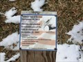
in 9/11 Memorial Sites This tree was planted in Mason Neck State Park in remembrance of the 10th Anniversary of September 11, 2001. posted by:  Don.Morfe Don.Morfe location: Virginia date approved: 10/27/2020 last visited: 10/28/2021 |
 view gallery view galleryS2.3 km |  Delaying Tactic - Lorton, VA Delaying Tactic - Lorton, VA
in Battlefields The marker is located at 7301 High Point Road in Mason Neck State Park near the Picnic Area, Lorton, VA USA 22079 posted by: Don.Morfe location: Virginia date approved: 09/19/2023 last visited: 09/19/2023 |
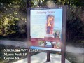
 view gallery view galleryS2.3 km |  'You Are Here' Maps-Delaying Tactic - Lorton, VA 'You Are Here' Maps-Delaying Tactic - Lorton, VA
in 'You Are Here' Maps The 'You Are Here' Map shows that you are at 7301 High Point Road in Mason Neck State Park near the Picnic Area, Lorton, VA USA 22079 posted by: Don.Morfe location: Virginia date approved: 09/18/2023 last visited: 09/19/2023 |
 view gallery view galleryS2.3 km |  Delaying Tactics Star-Spangled Banner National Historic Trail - Lorton, VA Delaying Tactics Star-Spangled Banner National Historic Trail - Lorton, VA
in War of 1812 The Battle of the White House Gun Battery, September 1-5, 1814, was the first military action in the region after the British attack on Washington. Named for a nearby white house, the battery was located at today’s Fort Belvoir. posted by: Don.Morfe location: Virginia date approved: 04/03/2020 last visited: 11/02/2021 |
 view gallery view galleryS2.3 km |  Delaying Tactics Star-Spangled Banner National Historic Trail - Lorton, VA Delaying Tactics Star-Spangled Banner National Historic Trail - Lorton, VA
in Signs of History The Battle of the White House Gun Battery, September 1-5, 1814, was the first military action in the region after the British attack on Washington. Named for a nearby white house, the battery was located at today’s Fort Belvoir. posted by: Don.Morfe location: Virginia date approved: 09/10/2022 last visited: 09/10/2022 |
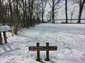
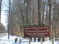 view gallery view galleryS2.3 km |  Mason Neck State Park - Lorton, VA Mason Neck State Park - Lorton, VA
in Official Local Tourism Attractions Just a short drive from Washington, D.C., this Northern Virginia park offers a range of outdoor activities and programs. Hiking trails, a large picnic area, playground, car-top canoe launch and a visitor center are among the park's features. posted by: Don.Morfe location: Virginia date approved: 09/10/2022 last visited: 09/10/2022 |
 view gallery view galleryS2.3 km |  Mason Neck State Park - Lorton, VA Mason Neck State Park - Lorton, VA
in Wikipedia Entries The park has an area of 1,814 acres (7.34 km2) and is home to bald eagles, great blue herons, ospreys, and many other types of wildlife. The park also contains white-tailed deer and many species of lichen. posted by: Don.Morfe location: Virginia date approved: 09/10/2022 last visited: 09/10/2022 |
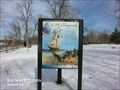 view gallery view galleryS2.3 km | War in the Chesapeake Star-Spangled Banner National Historic Trail - Lorton, VA in Signs of History During the War of 1812 the young United States was embroiled in conflict with Great Britain. From 1812 to 1815 Americans fought to protect their rights and economic independence. posted by: Don.Morfe location: Virginia date approved: 09/10/2022 last visited: 09/10/2022 |
 view gallery view galleryS2.3 km | War in the Chesapeake Star-Spangled Banner National Historic Trail - Lorton, VA in War of 1812 During the War of 1812 the young United States was embroiled in conflict with Great Britain. From 1812 to 1815 Americans fought to protect their rights and economic independence. posted by: Don.Morfe location: Virginia date approved: 04/03/2020 last visited: 11/02/2021 |
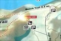 view gallery view galleryS2.3 km | 'You Are Here' Maps-Bay View Trail-Mason Neck State Park - Lorton VA in 'You Are Here' Maps The 'You Are Here' Map shows that you are on the Bay View Trail in Mason Neck State Park, Lorton VA. posted by: Don.Morfe location: Virginia date approved: 09/18/2023 last visited: 09/18/2023 |
 view gallery view galleryS2.3 km |  Bay View Trail-Mason Neck State Park - Lorton VA Bay View Trail-Mason Neck State Park - Lorton VA
in Hiking and walking trailheads The flat, shady Bay View Trail at Mason Neck State Park may clock in at just one-mile, but it’s a top pick among family-friendly hiking trails in Northern Virginia. posted by: Don.Morfe location: Virginia date approved: 09/10/2022 last visited: 09/10/2022 |
 view gallery view gallery W2.7 km W2.7 km
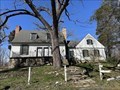
|  Fairfax Arms - Lorton, Virignia Fairfax Arms - Lorton, Virignia
in U.S. National Register of Historic Places Located near the southern end of Colchester Road. posted by:  flyingmoose flyingmoose location: Virginia date approved: 04/28/2023 last visited: never |
 view gallery view gallery N2.7 km N2.7 km
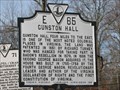
|  Gunston Hall Gunston Hall
in Virginia Historical Markers One of three markers at the intersection of Gunston Road and Old Colchester Road in Lorton/Mason Neck posted by: robert location: Virginia date approved: 01/29/2007 last visited: 03/27/2013 |
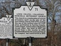 view gallery view galleryN2.7 km | Lewis Chapel/Cranford Memorial Methodist Church in Virginia Historical Markers One of three markers at the intersection of Gunston Road and Old Colchester Road in Lorton/Mason Neck posted by: robert location: Virginia date approved: 01/29/2007 last visited: 03/27/2013 |
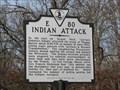 view gallery view galleryN2.7 km | Indian Attack in Virginia Historical Markers One of three markers at the intersection of Gunston Road and Old Colchester Road in Lorton/Mason Neck posted by: robert location: Virginia date approved: 01/29/2007 last visited: 03/27/2013 |
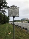 view gallery view galleryW2.9 km | Colchester in Virginia Historical Markers Located on the northbound side of Route 1 at Furnace Road. posted by: flyingmoose location: Virginia date approved: 10/15/2021 last visited: never |
 view gallery view galleryW3.1 km |  US 1 Train Truss Bridge - Woodridge, VA US 1 Train Truss Bridge - Woodridge, VA
in Truss Bridges A truss bridge used by trains that span a strait. The bridge runs parallel to US-1. posted by: saopaulo1 location: Virginia date approved: 05/16/2009 last visited: 05/30/2009 |
 view gallery view galleryW3.1 km |  US 1 Train Truss Bridge - Woodridge, VA US 1 Train Truss Bridge - Woodridge, VA
in Railroad Bridges A truss bridge for trains that go over a strait in Woodbridge, VA. posted by: saopaulo1 location: Virginia date approved: 05/18/2009 last visited: 02/20/2011 |
 view gallery view gallery E3.1 km E3.1 km
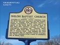
| Shiloh Baptist Church in Virginia Historical Markers According to tradition, African Americans from the Mason Neck area and others who had recently moved to Virginia from Maryland formed a religious congregation in 1869. posted by: Don.Morfe location: Virginia date approved: 03/14/2020 last visited: 10/20/2021 |
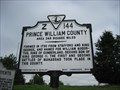 view gallery view galleryW3.4 km | Fairfax County / Prince William County in Virginia Historical Markers Located along Jefferson Davis Highway in Woodbridge, this markers marks the lines of Fairfax and Prince Williams counties. posted by: saopaulo1 location: Virginia date approved: 05/20/2009 last visited: 05/30/2009 |
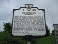 view gallery view galleryW3.4 km | Occoquan in Virginia Historical Markers A short history of the town of Occoquan. The plaque is by the Jefferson Davis Highway. In the 1600s, John Smith explored the region. posted by: saopaulo1 location: Virginia date approved: 05/20/2009 last visited: 05/30/2009 |
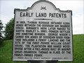 view gallery view galleryW3.4 km | Early Land Patents in Virginia Historical Markers A plaque along Hway 1 detailing the early land patents from Woodbridge. Woodbridge was once the name of a local plantation. posted by: saopaulo1 location: Virginia date approved: 05/20/2009 last visited: 05/30/2009 |
 view gallery view galleryW3.7 km |  Woodbridge Amtrak Station - Woodbridge, VA Woodbridge Amtrak Station - Woodbridge, VA
in Train Stations/Depots Amtrak station in Woodbridge, VA. posted by: saopaulo1 location: Virginia date approved: 05/18/2009 last visited: 05/30/2009 |
 view gallery view galleryW3.7 km |  Taco Bell - Gordon Blvd - Woodbridge, VA Taco Bell - Gordon Blvd - Woodbridge, VA
in Taco Bell Restaurants A stand alone Taco Bell on Gordon Blvd in Woodbridge. posted by: saopaulo1 location: Virginia date approved: 05/16/2009 last visited: 05/30/2009 |
 view gallery view galleryW3.7 km |  Aldi - Gordon Blvd - Woodbridge, VA Aldi - Gordon Blvd - Woodbridge, VA
in ALDI Stores An Aldi store on Gordon Blvd in Woodbridge, VA posted by: saopaulo1 location: Virginia date approved: 05/16/2009 last visited: 05/30/2009 |
|