 view gallery view gallery E34.3 km E34.3 km
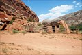
|   Captain Smith's Cabin Captain Smith's Cabin
in Homesteads Rock cabin built in Escalante Canyon by Captain Henry A. Smith in 1911. posted by:  MSDJ23 MSDJ23 location: Colorado date approved: 12/02/2009 last visited: 05/31/2015 |
 view gallery view gallery N48.9 km N48.9 km
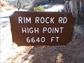
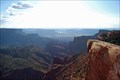
|  Rim Rock Road High Point - 6640' Rim Rock Road High Point - 6640'
in Elevation Signs The high point of the drive through Colorado National Monument. posted by:  WR7X WR7X location: Colorado date approved: 11/14/2013 last visited: never |
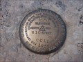 view gallery view galleryN49.9 km |  Cold Shivers Point - USGS CC11 1934 Cold Shivers Point - USGS CC11 1934
in U.S. Benchmarks A gem of a bench mark which is located in the Colorado National Monument at Cold Shivers Point. posted by: king.hubi location: Colorado date approved: 06/10/2009 last visited: 09/15/2018 |
 view gallery view galleryN50.1 km |  Serpents Trail - Grand Junction, CO Serpents Trail - Grand Junction, CO
in U.S. National Register of Historic Places Once the only road through the Colorado National Monument, a portion has been saved as a hiking trail. posted by: Outspoken1 location: Colorado date approved: 10/26/2011 last visited: 09/16/2014 |
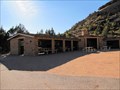 view gallery view galleryN50.2 km | Devils Kitchen Picnic Shelter - Grand Junction, CO in U.S. National Register of Historic Places This picnic area was repaired after vandalism in 2009 in preparation for the Colorado National Monument's 100th anniversary in 2011. posted by: Outspoken1 location: Colorado date approved: 10/26/2011 last visited: never |
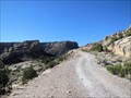
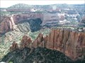
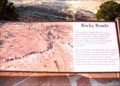 view gallery view galleryN50.5 km |  Rocky Roads Colorado National Monument - Grand Junction CO Rocky Roads Colorado National Monument - Grand Junction CO
in Signs of History The first people to witness this view were probably Indians who had to scale the steep cliffs and talus slopes. Later, ranchers dug narrow passages up into the canyons to bring their cattle to graze in the rich highland trails below. posted by: Don.Morfe location: Colorado date approved: 03/13/2022 last visited: 03/13/2022 |
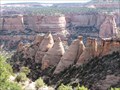 view gallery view galleryN50.5 km |  Colorado National Monument - Colorado On Board - Grand Junction to Fruita, CO Colorado National Monument - Colorado On Board - Grand Junction to Fruita, CO
in Monopoly in the Real World The above coordinates are the Grand Junction Entrance; the Fruita entrance is at N39° 07.109, W108° 43.873. The monument was created with CCC labor and celebrated its 100th year in 2011. posted by: Outspoken1 location: Colorado date approved: 10/31/2012 last visited: 03/29/2015 |
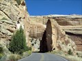 view gallery view galleryN50.5 km | Rim Rock Drive Historic District - Grand Junction, CO in U.S. National Register of Historic Places While the routing of the road was determined in November 1931 by National Park Service Engineer Thomas W. Secrest, it was the labor of the CCC that built most of this national treasure. posted by: Outspoken1 location: Colorado date approved: 10/25/2011 last visited: 05/25/2023 |
 view gallery view galleryN50.5 km |  Colorado National Monument - Grand Junction, CO Colorado National Monument - Grand Junction, CO
in Civilian Conservation Corps While Colorado National monument was developed in the late 1920s, it was the CCC that provided the labor to create much of this national treasure. posted by: Outspoken1 location: Colorado date approved: 10/27/2011 last visited: 03/29/2015 |
 view gallery view galleryN50.5 km |  NPS Colorado National Monument - Grand Junction, CO NPS Colorado National Monument - Grand Junction, CO
in National Parks of the World The Colorado National Monument is celebrating its 100th year (1911-2011) as a spectacular canyon lands park posted by: Outspoken1 location: Colorado date approved: 10/21/2011 last visited: 03/29/2015 |
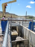 view gallery view galleryN50.7 km |  Redlands Diversion Dam Fish Ladder - Grand Junction, CO Redlands Diversion Dam Fish Ladder - Grand Junction, CO
in Fish Ladders Fish using this ladder are counted and sorted with only native fish being returned to the river. Endangered fish are microchipped (PIT Tag) so they may be tracked with radio receivers mounted along the rivers. posted by: Outspoken1 location: Colorado date approved: 07/08/2015 last visited: never |
 view gallery view galleryN50.7 km |  Redlands Diversion Dam - Grand Junction, CO Redlands Diversion Dam - Grand Junction, CO
in Water Dams The Redlands Diversion Dam provides both power and controls the river as well as a fish ladder to prevent the spread of non-native fish species. This dam provides both irrigation and hydro-electric power. posted by: Outspoken1 location: Colorado date approved: 07/08/2015 last visited: never |
 view gallery view gallery W52.5 km W52.5 km
|  Top of the World - Moab, Utah Top of the World - Moab, Utah
in Scenic Roadside Look-Outs The view from Top of the World is one of the most dramatic in the Moab area. From here, you can look out over the valley to Fisher Towers, the La Sal Mountains, Priest and Nun formations in Castle Valley, Arches National Park and western Colorado. posted by: 94RedRover location: Utah date approved: 10/29/2008 last visited: 02/26/2010 |
 view gallery view galleryW52.5 km |  Top of the World Overlook - Moab, Utah Top of the World Overlook - Moab, Utah
in Scenic Overlooks The view from Top of the World is one of the most dramatic in the Moab area. From here, you can look out over the valley to Fisher Towers, the La Sal Mountains, Priest and Nun formations in Castle Valley, Arches National Park and western Colorado. posted by: 94RedRover location: Utah date approved: 10/23/2008 last visited: 02/26/2010 |
 view gallery view galleryN53.6 km |  Pioneer Women - Grand Junction, CO Pioneer Women - Grand Junction, CO
in Figurative Public Sculpture This large monument is dedicated to the Pioneer Women who were instrumental in the settling of the West. posted by: Outspoken1 location: Colorado date approved: 01/17/2012 last visited: never |
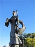 view gallery view galleryN53.6 km |  Pioneer Women - Grand Junction, CO Pioneer Women - Grand Junction, CO
in Occupational Monuments This monument honors the Pioneer Women who were instrumental in the settlement of the American West. posted by: Outspoken1 location: Colorado date approved: 01/18/2012 last visited: never |
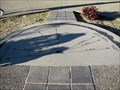 view gallery view galleryN53.6 km |  Eagle Rim Park Orientation Table - Grand Junction, CO Eagle Rim Park Orientation Table - Grand Junction, CO
in Orientation Tables This orientation table points out various geologic landmarks of the Grand Mesa. posted by: Outspoken1 location: Colorado date approved: 01/21/2012 last visited: never |
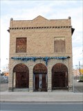
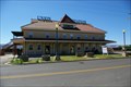 view gallery view galleryN54.4 km |  Union Station - Grand Junction CO Union Station - Grand Junction CO
in Train Stations/Depots Union Station - Grand Junction CO posted by: kJfishman location: Colorado date approved: 09/20/2010 last visited: 10/16/2011 |
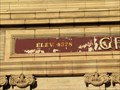 view gallery view galleryN54.4 km | Denver and Rio Grande Western Railroad Depot, Grand Junction, CO, USA - 4,578 feet in Elevation Signs The elevation and population signs are from 1906 when the Depot opened. posted by: Outspoken1 location: Colorado date approved: 02/04/2012 last visited: 11/11/2013 |
 view gallery view galleryN54.4 km |  Denver and Rio Grande Western Railroad Depot, Grand Junction, CO, USA - 1906 Population of 28,000 Denver and Rio Grande Western Railroad Depot, Grand Junction, CO, USA - 1906 Population of 28,000
in Population Signs This population sign was from 1906 when the Denver and Rio Grande Western Railroad Depot opened in Grand Junction, Colorado, USA. posted by: Outspoken1 location: Colorado date approved: 02/04/2012 last visited: never |
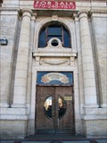 view gallery view galleryN54.4 km |  Denver and Rio Grande Western Railroad Depot - Grand Junction, CO Denver and Rio Grande Western Railroad Depot - Grand Junction, CO
in Frieze Art This depot was designed by famed Chicago architect Henry J. Schlacks in the Italian Renaissance style and opened in 1906. posted by: Outspoken1 location: Colorado date approved: 02/06/2012 last visited: never |
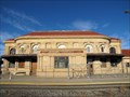 view gallery view galleryN54.4 km | Denver and Rio Grande Western Railroad Depot - Grand Junction, CO in U.S. National Register of Historic Places This NRHP is the older building. There is a newer, operating for AMTRAK depot just to the south. posted by: Outspoken1 location: Colorado date approved: 02/03/2012 last visited: never |
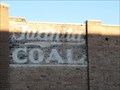 view gallery view galleryN54.6 km |  Juanita Coal & Larro Feeds - Grand Junction, CO Juanita Coal & Larro Feeds - Grand Junction, CO
in Ghost Signs These signs were close to the railroad depot area. posted by: Outspoken1 location: Colorado date approved: 01/17/2012 last visited: never |
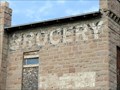 view gallery view galleryN54.6 km | Grocery - Grand Junction, CO in Ghost Signs This building is near the old Grand Junction Railroad Depot. posted by: Outspoken1 location: Colorado date approved: 11/26/2012 last visited: never |
 view gallery view galleryN54.6 km | Stranges Grocery - Grand Junction, CO in U.S. National Register of Historic Places This building is the only surviving structure from Grand Junction's 'Little Italy.' posted by: Outspoken1 location: Colorado date approved: 06/10/2015 last visited: never |
|