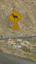
 view gallery view gallery E26.6 km E26.6 km
|   3 Miles of Bighorns, Walker Lake, NV 3 Miles of Bighorns, Walker Lake, NV
in Uncommon Crossing Signs This ara of Nevada has a population of bighorn near the road. posted by:  Queens Blessing Queens Blessing location: Nevada date approved: 12/12/2012 last visited: 09/28/2013 |
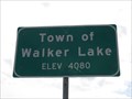 view gallery view galleryE26.7 km |  Town of Walker Lake, NV (Northern Approach) - 4080' Town of Walker Lake, NV (Northern Approach) - 4080'
in Elevation Signs The sign is at the north town limit of Walker Lake on Highway 95. posted by: WR7X location: Nevada date approved: 03/31/2013 last visited: 09/28/2013 |
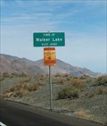 view gallery view galleryE27 km | Town of Walker Lake, NV, USA, Elevation 4,084 feet in Elevation Signs This town is at 4,084 feet in elevation. posted by: Queens Blessing location: Nevada date approved: 12/09/2012 last visited: 04/14/2013 |
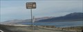 view gallery view galleryE27 km |  David Red Boy Schildt's: "Who Killed Walker Lake?", Walker Lake, NV David Red Boy Schildt's: "Who Killed Walker Lake?", Walker Lake, NV
in Immortalized in Lyrics Walker Lake
Who Killed Walker Lake?
Written and sung by: Dave Red Boy Schildt posted by: Queens Blessing location: Nevada date approved: 12/18/2012 last visited: 09/05/2016 |
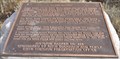
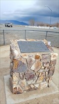
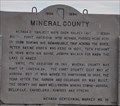 view gallery view gallery NE27.5 km NE27.5 km
|  Mineral County Mineral County
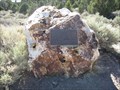
in Nevada Historical Markers Nevada State Historical Marker No. 16 is located on the east side of US Highway 95 in a campground next to Walker Lake. posted by: brwhiz location: Nevada date approved: 09/19/2012 last visited: 08/03/2023 |
 view gallery view gallery NW29.6 km NW29.6 km
| Wilson Canyon in Nevada Historical Markers This Nevada Historical Marker is mounted on a cut stone boulder located on the southeast side of Nevada Highway 208 at Copperbelt Drive at the south end of Wilson Canyon in Lyon County, Nevada. posted by: brwhiz location: Nevada date approved: 02/14/2013 last visited: never |
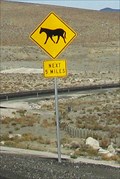 view gallery view galleryE30.3 km | 5 Miles of Horses, Walker Lake, NV in Uncommon Crossing Signs This area of Nevada is sparsely populated. posted by: Queens Blessing location: Nevada date approved: 12/12/2012 last visited: 09/28/2013 |
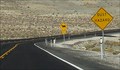 view gallery view galleryE30.3 km |  Dusty Road (because of horses), Walker Lake, NV Dusty Road (because of horses), Walker Lake, NV
in Unintentionally Funny Signs Perhaps they just don't want to be up front and blame the horses? posted by: Queens Blessing location: Nevada date approved: 12/25/2012 last visited: 09/28/2013 |
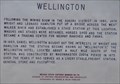 view gallery view galleryNW33.8 km | Wellington in Nevada Historical Markers Nevada State Historical Marker No. 74 is located in the triangular island formed at the junction of Nevada Highways 208 and 829. posted by: brwhiz location: Nevada date approved: 09/11/2012 last visited: never |
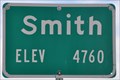 view gallery view galleryNW34.3 km | Smith ~ Elevation 4760 Feet in Elevation Signs This Elevation Sign is located on the north side of Nevada Highway 208 at the northeast town limits of Smith, Nevada. posted by: brwhiz location: Nevada date approved: 05/05/2013 last visited: never |
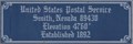 view gallery view galleryNW34.4 km | Smith, Nevada 89430 ~ Elevation 4760 Feet in Elevation Signs This Elevation Sign is mounted on the front of the US Post Office locagted at 2306 State Route 208 in Smith, Nevada. posted by: brwhiz location: Nevada date approved: 05/05/2013 last visited: never |
 view gallery view gallery SE34.4 km SE34.4 km
|  Aurora - Aurora, Nevada Aurora - Aurora, Nevada
in E Clampus Vitus Historical Markers This marker signifies the ghost town of Aurora, Nevada. posted by:  chrissyml chrissyml location: Nevada date approved: 07/08/2012 last visited: never |
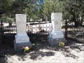 view gallery view gallerySE34.4 km |  Aurora Cemetery - Aurora, Nevada Aurora Cemetery - Aurora, Nevada
in Worldwide Cemeteries This is the Aurora Cemetery in Aurora, Nevada. posted by: chrissyml location: Nevada date approved: 01/02/2013 last visited: never |
 view gallery view galleryNW34.4 km |  Smith, Nevada 89430 Smith, Nevada 89430
in U.S. Post Offices This Post Office is located at 2306 State Route 208 in Smith, Nevada. posted by: brwhiz location: Nevada date approved: 01/16/2012 last visited: never |
 view gallery view galleryNW34.4 km | Wellington, Nevada 89444 in U.S. Post Offices This Post Office is located at 2818 State Route 208 in Wellington, Nevada. posted by: brwhiz location: Nevada date approved: 01/16/2012 last visited: never |
 view gallery view gallerySE34.8 km |  Aurora, Nevada Aurora, Nevada
in Ghost Towns Aurora was a town in Nevada that was booming in the 1860s and 1870s. posted by: chrissyml location: Nevada date approved: 07/08/2012 last visited: never |
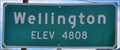 view gallery view galleryNW34.8 km | Wellington ~ Elevation 4808 Feet in Elevation Signs This Elevation Sign is located on the southwest side of Nevada Highway 208 at the northwest town limits of Wellington, Nevada. posted by: brwhiz location: Nevada date approved: 05/05/2013 last visited: never |
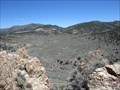
 view gallery view gallery SW37.2 km SW37.2 km
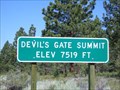
| Devil's Gate Summit 7519 Feet - CA in Elevation Signs Devil's Gate Pass is located in Mono County, CA. This is the highest point on that pass. posted by: Free2bme29 location: California date approved: 07/11/2009 last visited: 09/14/2021 |
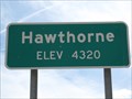 view gallery view galleryE37.2 km | Hawthorne, NV (Northwest Approach) - 4320' in Elevation Signs The sign is at the northwest city limit of Hawthorne on Highway 95. posted by: WR7X location: Nevada date approved: 03/28/2013 last visited: 09/28/2013 |
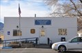
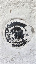 view gallery view galleryE37.5 km |  JR0085 - USC&GC 'E 359' BM - Hawthorne, NV JR0085 - USC&GC 'E 359' BM - Hawthorne, NV
in U.S. Benchmarks A NGS benchmark located at a gymnasium in Hawthorne. posted by: NW_history_buff location: Nevada date approved: 04/04/2018 last visited: never |
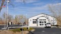
 view gallery view galleryE37.5 km | The Pillar of Light - Hawthorne, NV in E Clampus Vitus Historical Markers An ECV marker located at a rest area which also acts as a veterans memorial and a dog park. posted by: NW_history_buff location: Nevada date approved: 04/05/2018 last visited: never |
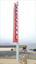 view gallery view galleryE37.5 km |  Hawthorne Club Sign - Hawthorne, NV Hawthorne Club Sign - Hawthorne, NV
in Neon Signs A restored neon sign resides at a rest area which also acts as a veterans memorial and dog park. posted by: NW_history_buff location: Nevada date approved: 04/04/2018 last visited: never |
 view gallery view galleryE37.5 km |  ONLY - Courthouse to Serve Two Counties in Nevada ONLY - Courthouse to Serve Two Counties in Nevada
in Superlatives The former Mineral County Courthouse currently sits vacant and was listed in the National Register of Historic Places in 1982. posted by: NW_history_buff location: Nevada date approved: 04/03/2018 last visited: never |
 view gallery view galleryE37.5 km |  Mineral County Courthouse (former) - Hawthorne, NV Mineral County Courthouse (former) - Hawthorne, NV
in Courthouses This former courthouse has the distinction of being the only courthouse in the state of Nevada to serve two counties. It was listed in the National Register of Historic Places in 1982. posted by: NW_history_buff location: Nevada date approved: 04/08/2018 last visited: never |
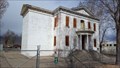 view gallery view galleryE37.5 km |  Mineral County Courthouse - Hawthorne, NV Mineral County Courthouse - Hawthorne, NV
in U.S. National Register of Historic Places A former courthouse in Hawthorne was listed in the NRHP database in January of 1982. posted by: NW_history_buff location: Nevada date approved: 04/04/2018 last visited: never |
|