 view gallery view gallery E1.9 km E1.9 km
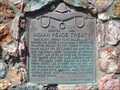
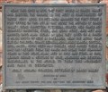
|   Indian Peace Treaty - 254 Indian Peace Treaty - 254
in D.U.P. Historic Markers The Daughters of Utah Pioneers Market Number 254 - Indian Peace Treaty, north of Burrville, Utah on Hwy 24. posted by:  Chasing Blue Sky Chasing Blue Sky location: Utah date approved: 05/10/2011 last visited: 09/19/2023 |
 view gallery view galleryE1.9 km |  Indian Peace Treaty - 254 - Burrville, UT Indian Peace Treaty - 254 - Burrville, UT
in Utah Historical Markers The Daughters of Utah Pioneers Market Number 254 - Indian Peace Treaty, north of Burrville, Utah on Hwy 24. posted by: Chasing Blue Sky location: Utah date approved: 05/11/2011 last visited: 09/19/2023 |
 view gallery view gallery SE4.7 km SE4.7 km
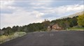
|  Oak Springs Rest Area Oak Springs Rest Area
in Highway Rest Areas This Highway Rest Area is located on the east side of Utah Highway 24 just north of the junction with Hogback Road near Koosharem, Utah. posted by:  brwhiz brwhiz location: Utah date approved: 03/14/2013 last visited: 09/04/2011 |
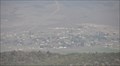
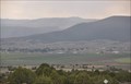 view gallery view gallerySE5 km |  Koosharem from Utah Highway 24 Koosharem from Utah Highway 24
in Cityscapes This view of Koosharem, Utah is from Utah Highway 24 at the junction with Hogback Road. posted by: brwhiz location: Utah date approved: 04/02/2013 last visited: never |
 view gallery view gallery S5.8 km S5.8 km
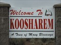
|  Koosharem, UT Koosharem, UT
in Welcome Signs The Welcome sign at the north end of Koosharem, Utah. posted by: Chasing Blue Sky location: Utah date approved: 05/01/2011 last visited: 04/25/2011 |
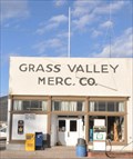
 view gallery view galleryS6.6 km |  First House in Grass Valley First House in Grass Valley
in First of its Kind The first house in Grass Valley was built in 1875 in what is now Koosharem, Utah. posted by: brwhiz location: Utah date approved: 01/20/2013 last visited: never |
 view gallery view galleryS6.6 km | First Store and Post Office in Grass Valley in First of its Kind The first store and post office in Grass Valley was managed by F.P. Peterson, builder of the first house in Grass Valley, in what is now Koosharem, Utah. posted by: brwhiz location: Utah date approved: 01/20/2013 last visited: never |
 view gallery view galleryS6.6 km | Noble Mormon Pioneers. Settlers of Grass Valley in D.U.P. Historic Markers This historical marker, erected by the Boy Scouts and the Daughters of Utah Pioneers, is located at about 75 East 100 North in Koosharem, Utah. posted by: brwhiz location: Utah date approved: 01/22/2013 last visited: never |
 view gallery view galleryS6.6 km | Noble Mormon Pioneers. Settlers of Grass Valley in Utah Historical Markers This historical marker, erected by the Boy Scouts and the Daughters of Utah Pioneers, is located at about 75 East 100 North in Koosharem, Utah. posted by: brwhiz location: Utah date approved: 01/20/2013 last visited: never |
 view gallery view galleryS6.8 km | Koosharem Amusement Hall in Utah Historical Markers This Utah Historical Marker is mounted on top of a stone monument in front of the historic Koosharem Amusement Hall at 90 N Main Street (Utah Highway 62) in Koosharem, Utah. posted by: brwhiz location: Utah date approved: 01/18/2013 last visited: never |
 view gallery view galleryS6.9 km |  Koosharem, Utah 84744 Koosharem, Utah 84744
in U.S. Post Offices This Post Office is located at 5 N Main Street in Koosharem, Utah. posted by: brwhiz location: Utah date approved: 12/25/2011 last visited: never |
 view gallery view galleryE8.7 km |  Hancock Spring - Sevier County, UT Hancock Spring - Sevier County, UT
in Natural Springs Hancock Spring is situated near the south end of the Fish Lake Hightop Plateau, west of Fish Lake, in Sevier County, Utah. posted by: Chasing Blue Sky location: Utah date approved: 10/05/2012 last visited: 09/04/2011 |
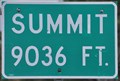 view gallery view gallerySE9.3 km |  Fishlake Summit ~ Elevation 9036 Feet Fishlake Summit ~ Elevation 9036 Feet
in Elevation Signs This Elevation Sign is located on the south side of Utah Highway 25 at milepost 4 and the southwestern boundary of the Fishlake National Forest in Sevier County, Utah. posted by: brwhiz location: Utah date approved: 01/21/2013 last visited: never |
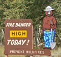 view gallery view gallerySE9.8 km |  Fishlake National Forest Smokey Fishlake National Forest Smokey
in Smokey Bear Sign Sightings This Smokey Bear sign is located on the south side of Utah Highway 25 at the southwestern boundary of the Fishlake National Forest in Sevier County, Utah. posted by: brwhiz location: Utah date approved: 01/22/2013 last visited: never |
 view gallery view galleryS10.6 km | Koosharem from Utah Highway 25 in Cityscapes This view of Koosharem, Utah is from high atop the ridge on the eastern edge of the valley on Utah Highway 25 just above the junction with Utah Highway 24. posted by: brwhiz location: Utah date approved: 02/06/2013 last visited: never |
 view gallery view gallerySE11.6 km |  Old Spanish Trail Caravan ~ Sevier County, Utah Old Spanish Trail Caravan ~ Sevier County, Utah
in Silhouette Public Art Sculptures This Silhouette Public Art Sculpture accompanies an historical marker at the parking area for the Lakeshore Trail on the southeast side of Utah Highway 25, near the southwest corner of Fish Lake. posted by: brwhiz location: Utah date approved: 03/13/2013 last visited: never |
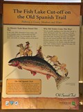 view gallery view gallerySE11.6 km |  The Fish Lake Cut-off on the Old Spanish Trail The Fish Lake Cut-off on the Old Spanish Trail
in Wagon Roads and Trails The historical marker for this historic trade route is located in the parking area for the Lakeside Trail on the southeast side of Utah Highway 25, near the southwest corner of Fish Lake. posted by: brwhiz location: Utah date approved: 03/14/2013 last visited: never |
 view gallery view gallerySE11.6 km | The Fish Lake Cut-off on the Old Spanish Trail in Utah Historical Markers This Historical Marker is located in the parking area for the Lakeside Trail on the southeast side of Utah Highway 25, near the southwest corner of Fish Lake. posted by: brwhiz location: Utah date approved: 03/14/2013 last visited: never |
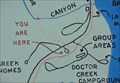 view gallery view gallerySE11.6 km |  Doctor Creek Trailhead Doctor Creek Trailhead
in 'You Are Here' Maps You Are Here at the parking lot for the Doctor Creek Trailhead near the southern end of Fish Lake Utah. posted by: brwhiz location: Utah date approved: 02/02/2013 last visited: never |
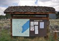 view gallery view gallerySE11.6 km |  Doctor Creek Trailhead Doctor Creek Trailhead
in Hiking and walking trailheads This Hiking and Walking Trailhead, along with one other, is located on the southeast side of Utah Highway 25, near the southwest corner of Fish Lake and about one-half mile southwest of the Lakeside Resort store. posted by: brwhiz location: Utah date approved: 03/14/2013 last visited: never |
 view gallery view gallerySE11.6 km | Lakeshore National Recreation Trail ~ South Trailhead in Hiking and walking trailheads This Hiking and Walking Trailhead is located on the southeast side of Utah Highway 25, near the southwest corner of Fish Lake and about one-half mile southwest of the Lakeside Resort store. posted by: brwhiz location: Utah date approved: 03/14/2013 last visited: never |
 view gallery view galleryE11.6 km |  Fish Lake Hightop - Sevier County, UT Fish Lake Hightop - Sevier County, UT
in Geographic High Points Fish Lake Hightop is the high point in Sevier County, Utah. As one would infer, it is at the top of the mountain ridge west of, and overlooking, Fish Lake. posted by: Chasing Blue Sky location: Utah date approved: 10/07/2012 last visited: 09/04/2011 |
 view gallery view galleryE11.6 km |  Fish Lake Hightop - Sevier County, UT Fish Lake Hightop - Sevier County, UT
in Mountain Summits Fish Lake Hightop is the high point in Sevier County, Utah. As one would infer, it is at the top of the mountain ridge west of, and overlooking, Fish Lake. posted by: Chasing Blue Sky location: Utah date approved: 10/06/2012 last visited: 09/04/2011 |
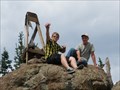
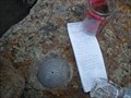 view gallery view galleryE11.6 km |  Fish Lake Hightop Summit Register - Sevier County, UT Fish Lake Hightop Summit Register - Sevier County, UT
in Summit Registers This register is at Fish Lake Hightop, which is the high point in Sevier County, Utah. As one would infer, it is in the mountain ridge west of, and overlooking, Fish Lake. posted by: Chasing Blue Sky location: Utah date approved: 10/18/2012 last visited: 09/04/2011 |
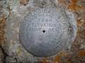 view gallery view galleryE11.6 km |  Fish Lake - JN0377 - Sevier County, UT Fish Lake - JN0377 - Sevier County, UT
in U.S. Benchmarks This Benchmark is at Fish Lake Hightop, which is the high point of Sevier County, Utah. As one would infer, it is in the mountain ridge west of, and overlooking, Fish Lake. posted by: Chasing Blue Sky location: Utah date approved: 10/05/2012 last visited: 09/04/2011 |
|