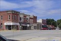
 view gallery view gallery W9 km W9 km
|   Windsor, Missouri Windsor, Missouri
in Wikipedia Entries Mainly in Henry County this city spills over into a part of Pettis County. posted by:  YoSam. YoSam. location: Missouri date approved: 03/24/2016 last visited: never |
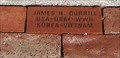 view gallery view galleryW9.2 km |  Our Flag Veterans Memorial - Windsor, MO Our Flag Veterans Memorial - Windsor, MO
in Donated Engraved Bricks and Pavers Best I can determine, this was a local historical society memorial, and sold the bricks to help finance it. posted by: YoSam. location: Missouri date approved: 07/06/2014 last visited: never |
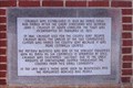
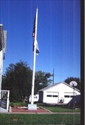 view gallery view galleryW9.2 km |  Our Flag Veterans Memorial, Windsor, MO Our Flag Veterans Memorial, Windsor, MO
in Non-Specific Veteran Memorials "...Our Flag Was Still There" posted by: YoSam. location: Missouri date approved: 05/09/2008 last visited: never |
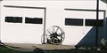 view gallery view galleryW9.3 km |  Wheel of What Purpose? ~ Windsor, MO Wheel of What Purpose? ~ Windsor, MO
in Wagon Wheels Holding the wall up? posted by: YoSam. location: Missouri date approved: 05/14/2014 last visited: never |
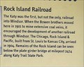
 view gallery view galleryW9.3 km |  LAST - Train to Leave Windsor, Missouri LAST - Train to Leave Windsor, Missouri
in Last of its Kind This marker is actually located at the KATY Trail trailhead in Windsor. Please view the photo gallery, much additional history and detailed photos highlight this marker. posted by: YoSam. location: Missouri date approved: 04/10/2020 last visited: never |
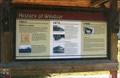
 view gallery view galleryW9.3 km |  History of Windsor - 1855 to 1999 - Windsor, MO History of Windsor - 1855 to 1999 - Windsor, MO
in Timelines This marker is actually located at the KATY Trail trailhead in Windsor. Please view the photo gallery, much additional history and detailed photos highlight this marker. posted by: YoSam. location: Missouri date approved: 06/01/2015 last visited: never |
 view gallery view galleryW9.3 km |  FIRST - Railroad & Platted - Windsor, MO FIRST - Railroad & Platted - Windsor, MO
in First of its Kind This marker is actually located at the KATY Trail trailhead in Windsor. Please view the photo gallery, much additional history and detailed photos highlight this marker. posted by: YoSam. location: Missouri date approved: 04/10/2020 last visited: never |
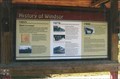
 view gallery view galleryW9.3 km |  History of Windsor - Windsor, MO History of Windsor - Windsor, MO
in Missouri Historical Markers This marker is actually located at the KATY Trail trailhead in Windsor. Please view the photo gallery, much additional history and detailed photos highlight this marker. posted by: YoSam. location: Missouri date approved: 05/13/2014 last visited: never |
 view gallery view galleryW9.3 km |  Windsor, Clinton County, Missouri Windsor, Clinton County, Missouri
in Human Migration Monuments This marker is actually located at the KATY Trail trailhead in Windsor. Please view the photo gallery, much additional history and detailed photos highlight this marker. posted by: YoSam. location: Missouri date approved: 04/16/2020 last visited: never |
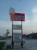 view gallery view gallery SE14.6 km SE14.6 km
|  Estes Drive Inn - Neon Estes Drive Inn - Neon
in Artistic Neon Lights Estes Drive Inn Lincoln,Missouri posted by:  GEO*Trailblazer 1 GEO*Trailblazer 1 location: Missouri date approved: 04/05/2007 last visited: 04/07/2007 |
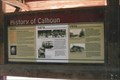
 view gallery view galleryW18 km | Calhoun, Henry County, Missouri in Human Migration Monuments The potters, the railroad, those who made the county grow...oldest town in county...From being the first town in the county, to being pushed aside for county seat, to a state park replacing the railroad. posted by: YoSam. location: Missouri date approved: 02/04/2020 last visited: never |
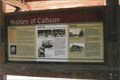 view gallery view galleryW18 km | History of Calhoun - 1835 to 1999 - Calhoun, MO in Timelines From being the first town in the county, to being pushed aside for county seat, to a state park replacing the railroad. posted by: YoSam. location: Missouri date approved: 05/31/2015 last visited: never |
 view gallery view galleryW18 km | FIRST - Town in County - Calhoun, MO in First of its Kind also first house....sad history of boom and bust... posted by: YoSam. location: Missouri date approved: 01/19/2020 last visited: never |
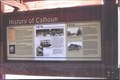 view gallery view galleryW18 km | History of Calhoun - Calhoun, MO in Missouri Historical Markers From being the first town in the county, to being pushed aside for county seat, to a state park replacing the railroad. posted by: YoSam. location: Missouri date approved: 05/03/2008 last visited: 09/25/2007 |
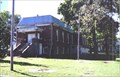
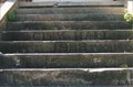 view gallery view galleryW18 km |  Old City Hall - 1922 - Calhoun, MO Old City Hall - 1922 - Calhoun, MO
in Dated Architectural Structures Multifarious Name and date incised in the front steps... posted by: YoSam. location: Missouri date approved: 02/03/2020 last visited: never |
 view gallery view galleryW18 km | Calhoun - Calhoun, MO in Missouri Historical Markers Local marker of small town. Was big in the pottery business. posted by: YoSam. location: Missouri date approved: 05/02/2008 last visited: 09/12/2010 |
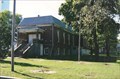
 view gallery view galleryW18 km |  Calhoun, Missouri Calhoun, Missouri
in City and Town Halls Once proud city hall, now a community center, and the lawn is a village park. posted by: YoSam. location: Missouri date approved: 05/04/2008 last visited: 09/12/2010 |
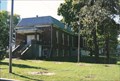 view gallery view galleryW18 km | Calhoun, Missouri in Wikipedia Entries Once proud city hall, now a community center, and the lawn is a village park. posted by: YoSam. location: Missouri date approved: 03/24/2016 last visited: never |
 view gallery view galleryW18 km |  Calhoun, Missouri Calhoun, Missouri
in People-Named Places Oldest city in the county, snubbed for county seat, named for SC Senator... posted by: YoSam. location: Missouri date approved: 02/01/2020 last visited: never |
 view gallery view gallery E19.8 km E19.8 km
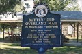
|  Butterfield Stage and Overland Mail - Cole Camp, MO Butterfield Stage and Overland Mail - Cole Camp, MO
in Wagon Roads and Trails State marker points you in the direction of the actual relay station. posted by: YoSam. location: Missouri date approved: 09/27/2019 last visited: never |
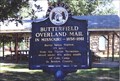 view gallery view galleryE19.8 km | Butterfield Overland Mail - Cole Camp, MO in Missouri Historical Markers State marker points you in the direction of the actual relay station. posted by: YoSam. location: Missouri date approved: 02/29/2008 last visited: 09/17/2007 |
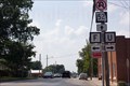 view gallery view galleryE19.8 km |  F road and U road F road and U road
in Unintentionally Funny Signs Only in Missouri, which way to route F or route U? posted by: singleshot54 location: Missouri date approved: 11/21/2014 last visited: never |
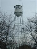 view gallery view galleryE19.8 km |  Cole Camp - Water Tank Cole Camp - Water Tank
in Water Towers Cole Camp,Missouri Water Tank posted by: GEO*Trailblazer 1 location: Missouri date approved: 03/30/2007 last visited: 03/25/2012 |
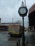 view gallery view galleryE20 km |  Citizen Bank Clock - Cole Camp,Mo. Citizen Bank Clock - Cole Camp,Mo.
in Town Clocks Citizens-Farmers Bank Clock 1898 Cole Camp Missouri posted by: GEO*Trailblazer 1 location: Missouri date approved: 05/10/2007 last visited: 03/25/2012 |
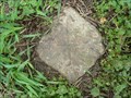 view gallery view galleryE20.3 km |  SCHNACKENBURG REFERENCE STONE SCHNACKENBURG REFERENCE STONE
in U.S. Historic Survey Stones and Monuments REFERENCE STONE FOR SCHNACKENBURG STATION posted by: GEO*Trailblazer 1 location: Missouri date approved: 03/31/2007 last visited: 03/31/2007 |
|