 view gallery view gallery W1.1 km W1.1 km
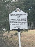
|   General Daniel E. Sickles Union Army General Daniel E. Sickles Union Army
in Maryland Historical Markers Marker for General Daniel E. Sickles HQ Location in Charles County, MD. posted by:  40 40 location: Maryland date approved: 02/02/2023 last visited: never |
 view gallery view gallery NW3.4 km NW3.4 km
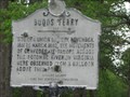
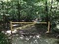
| Budds Ferry in Maryland Historical Markers Marker for Budds Ferry. Looks like some confederates got to it. posted by: trainbug location: Maryland date approved: 04/29/2011 last visited: never |
 view gallery view gallery N4.2 km N4.2 km
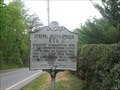
| General Joseph Hooker in Maryland Historical Markers Marker for General Joseph Hooker. Looks like the Confederates got to this one also. posted by: trainbug location: Maryland date approved: 04/30/2011 last visited: 05/13/2019 |
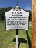 view gallery view galleryN4.5 km | Rum Point in Maryland Historical Markers Located at the intersection of Route 224 and Stumpneck Road posted by: flyingmoose location: Maryland date approved: 01/27/2023 last visited: never |
 view gallery view gallery SW5.6 km SW5.6 km
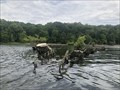
|  Mallows Bay Ghost Fleet - Nanjemoy, Maryland Mallows Bay Ghost Fleet - Nanjemoy, Maryland
in Canoe/Kayak Trips Located along the Potomac River, this trip will take you among the sunken vessels in Mallows Bay. posted by: flyingmoose location: Maryland date approved: 12/21/2022 last visited: never |
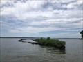
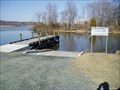
 view gallery view gallerySW5.6 km |  Mallows Bay - Nanjemoy, Maryland Mallows Bay - Nanjemoy, Maryland
in Boat Ramps Located within Mallows Bay Park, at the end of the main parking lot. posted by: flyingmoose location: Maryland date approved: 02/17/2023 last visited: never |
 view gallery view gallerySW5.8 km |  Mallows Bay Ghost Fleet - Nanjemoy, Maryland Mallows Bay Ghost Fleet - Nanjemoy, Maryland
in Shipwrecks Located on the coast of the Potomac River in Charles County, Maryland. posted by: flyingmoose location: Maryland date approved: 11/18/2022 last visited: never |
 view gallery view gallerySW5.8 km |  Mallows Bay--Widewater Historic and Archeological District - Nanjemoy, Maryland Mallows Bay--Widewater Historic and Archeological District - Nanjemoy, Maryland
in U.S. National Register of Historic Places Located along the Potomac River within Mallows Bay Park. posted by: flyingmoose location: Maryland date approved: 12/22/2022 last visited: never |
 view gallery view gallerySW5.8 km |  Mallows Bay - Nanjemoy, Maryland Mallows Bay - Nanjemoy, Maryland
in World War I Sites Located on the coast of the Potomac River in Charles County, Maryland. posted by: flyingmoose location: Maryland date approved: 11/18/2022 last visited: never |
 view gallery view galleryN6.1 km |  William Smallwood - Marbury, Maryland William Smallwood - Marbury, Maryland
in American Revolutionary War Veteran Graves Grave of a Revolutionary located next to his former home. posted by: flyingmoose location: Maryland date approved: 08/19/2023 last visited: never |
 view gallery view galleryN6.1 km |  William Smallwood - Marbury, Maryland William Smallwood - Marbury, Maryland
in Grave of a Famous Person Grave of a Revolutionary located next to his former home. posted by: flyingmoose location: Maryland date approved: 07/27/2023 last visited: never |
 view gallery view galleryN6.1 km |  William Smallwood - Marbury, Maryland William Smallwood - Marbury, Maryland
in American Revolution Patriot Graves Grave of a Revolutionary located next to his former home. posted by: flyingmoose location: Maryland date approved: 08/20/2023 last visited: never |
 view gallery view gallery E6.3 km E6.3 km
|  St. Ignatius of Loyola Catholic Church- Hilltop MD St. Ignatius of Loyola Catholic Church- Hilltop MD
in This Old Church St. Ignatius of Loyola, Hilltop, is located in Charles County, Maryland.
The people of this historic parish have worshiped God and spread the Gospel of Jesus Christ in western Charles County since 1851. Church built in 1859. posted by:  Don.Morfe Don.Morfe location: Maryland date approved: 02/09/2023 last visited: 02/10/2023 |
 view gallery view galleryE6.3 km | St. Ignatius of Loyola - Hilltop MD in Roman Catholic Churches Small county church established 1859. During COVID-19 they are livestreaming on YouTube! Visit our channel: YouTube-St. Catherine & St. Ignatius. posted by: Don.Morfe location: Maryland date approved: 01/09/2021 last visited: 10/29/2021 |
 view gallery view gallery NE6.9 km NE6.9 km
| Smallwood’s Home in Maryland Historical Markers Located at the intersection of Route 224 and Sweden Point Road. posted by: flyingmoose location: Maryland date approved: 01/27/2023 last visited: never |
 view gallery view galleryN7.1 km |  John Smith Explores the Chesapeake-Native Inhabitants - Marbury, MD John Smith Explores the Chesapeake-Native Inhabitants - Marbury, MD
in Civil Rights Memorials The marker is at 2750 Sweden Point Road, near the Discovery Room in Smallwood State Park, Marbury, MD USA 20658 posted by: Don.Morfe location: Maryland date approved: 09/18/2023 last visited: 09/18/2023 |
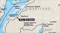 view gallery view galleryN7.1 km |  'You Are Here' Maps-Rich Resources-Captain John Smith Chesapeake National Historic Trail - Marbury, MD 'You Are Here' Maps-Rich Resources-Captain John Smith Chesapeake National Historic Trail - Marbury, MD
in 'You Are Here' Maps The 'You Are Here' Map shows that you are at 2750 Sweden Point Road, near the Discovery Room in Smallwood State Park, Marbury, MD USA 20658 posted by: Don.Morfe location: Maryland date approved: 09/18/2023 last visited: 09/18/2023 |
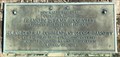
 view gallery view galleryN7.1 km |  Rich Resources Captain John Smith Chesapeake National Historic Trail - Marbury, MD Rich Resources Captain John Smith Chesapeake National Historic Trail - Marbury, MD
in Signs of History John Smith and his crew spent a month exploring the Potomac River in 1608, during the first voyage through the region. Smith mapped the town of Pamacocack at the mouth of the Mattawoman Creek. posted by: Don.Morfe location: Maryland date approved: 01/19/2020 last visited: 09/25/2021 |
 view gallery view galleryW7.7 km |  Marine Reservation Quantico - Quantico, Virginia Marine Reservation Quantico - Quantico, Virginia
in Grand Opening A monument that marks where the first tree was cut to create what is now Marine Corp Base Quantico posted by: flyingmoose location: Virginia date approved: 09/15/2022 last visited: never |
 view gallery view gallerySW8 km |  Douglas Point - Nanjemoy, Maryland Douglas Point - Nanjemoy, Maryland
in Hiking and walking trailheads Located along Riverside Road. posted by: flyingmoose location: Maryland date approved: 01/31/2023 last visited: never |
 view gallery view gallerySW8.2 km |  Blue Banks Beach - Nanjemoy, Maryland Blue Banks Beach - Nanjemoy, Maryland
in Beaches A beach great for enjoying the calm waters of Wades Bay. posted by: flyingmoose location: Maryland date approved: 01/30/2023 last visited: never |
 view gallery view gallerySW8.4 km |  Blue Banks Beach - Nanjemoy, Maryland Blue Banks Beach - Nanjemoy, Maryland
in Paleontology and Fossils The beach along the Blue Banks is a great spot to collect shark teeth. posted by: flyingmoose location: Virginia date approved: 02/03/2023 last visited: never |
 view gallery view galleryW8.4 km | Commanding General's Quarters, Quantico Marine Base - Quantico, VA in U.S. National Register of Historic Places Located on north bound side of Neville Road. posted by: flyingmoose location: Virginia date approved: 04/28/2023 last visited: never |
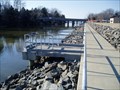 view gallery view galleryW8.5 km |  Chopawamsic Creek, Handicap Access, MCB Quantico, VA Chopawamsic Creek, Handicap Access, MCB Quantico, VA
in Fishing Holes Six concrete piers facing Chopawamsic Creek for handicapped fishing access. Adjacent to Potomac River. ID required to enter base. posted by: garmin_geek location: Virginia date approved: 02/27/2009 last visited: never |
 view gallery view galleryW8.9 km | Lower Chopawamsic Creek, MCB Quantico, VA in Boat Ramps Chopawamsic Creek ramp closest to the Potomac River. ID required to get on base. Launch and recover day light hours only. posted by: garmin_geek location: Virginia date approved: 03/07/2009 last visited: never |
|