 view gallery view gallery E2.6 km E2.6 km
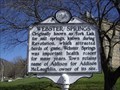
|   Webster Springs Webster Springs
in West Virginia Historical Markers Some background information about Webster Springs. posted by:  Paintedwarrior Paintedwarrior location: West Virginia date approved: 03/12/2012 last visited: 03/16/2012 |
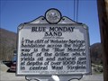 view gallery view galleryE2.6 km | Blue Monday Sand in West Virginia Historical Markers Some information about oil and natural gas found within the cliffs near Webster Springs. posted by: Paintedwarrior location: West Virginia date approved: 03/12/2012 last visited: 03/16/2012 |
 view gallery view gallery SW12.7 km SW12.7 km
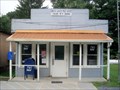
|  Cowen, WV. 26206 Cowen, WV. 26206
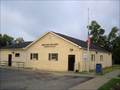
in U.S. Post Offices Cowen WV Post Office posted by: dukemartin location: West Virginia date approved: 08/15/2012 last visited: never |
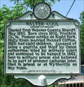 view gallery view gallery N13.5 km N13.5 km
| Walter Cool in West Virginia Historical Markers A historical marker dedicated to the first sheriff of Webster County, located beside State Route 15, just north of Diana, WV. posted by: Cache Sleuth location: West Virginia date approved: 11/08/2009 last visited: 02/20/2012 |
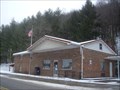
 view gallery view gallerySW18.5 km | Camden on Gauley, WV - 26208 in U.S. Post Offices The main post office for Camden on Gauley, a small town located in western Webster County, West Virginia. posted by: Cache Sleuth location: West Virginia date approved: 04/10/2009 last visited: 06/11/2012 |
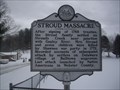 view gallery view gallerySW19.6 km | Stroud Massacre in West Virginia Historical Markers A accounting of the last Native American attack in Webster County. posted by: Paintedwarrior location: West Virginia date approved: 02/16/2016 last visited: never |
 view gallery view gallerySW19.8 km | Webster County / Nicholas County in West Virginia Historical Markers A newer historical marker beside State Route 20 on the border of Nicholas and Webster Counties, about 1/2 mile west of Camden on Gauley, WV. posted by: Cache Sleuth location: West Virginia date approved: 04/08/2009 last visited: 08/11/2012 |
 view gallery view galleryN19.8 km | Hacker Valley in West Virginia Historical Markers Information about the town of Hacker Valley posted by: Paintedwarrior location: West Virginia date approved: 03/12/2012 last visited: 03/16/2012 |
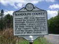 view gallery view galleryE22.7 km | Randolph / Webster County in West Virginia Historical Markers A two sided sign telling us where the counties were formed from and how they were named. posted by: Paintedwarrior location: West Virginia date approved: 06/04/2013 last visited: 06/14/2013 |
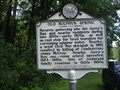 view gallery view galleryN23.3 km | Old Sulphur Spring in West Virginia Historical Markers A sign telling of what occurred near this rest stop for water. posted by: Paintedwarrior location: West Virginia date approved: 07/28/2013 last visited: 08/01/2013 |
 view gallery view gallery W24.3 km W24.3 km
| Braxton County / Nicholas County in West Virginia Historical Markers A newer historical marker located beside County Route 19/40 (Old Turnpike Road) near the border of Nicholas and Braxton Counties, about 3/4 mile north of Bays, West Virginia. posted by: Cache Sleuth location: West Virginia date approved: 05/04/2009 last visited: 02/15/2016 |
 view gallery view gallerySW25.3 km | Craigsville, WV. 26205 in U.S. Post Offices Craigsville WV Post Office posted by: dukemartin location: West Virginia date approved: 08/15/2012 last visited: never |
 view gallery view gallery NW25.7 km NW25.7 km
| Little Birch WV 26629 Post Office in U.S. Post Offices Little Birch WV 26629 Post Office posted by: dukemartin location: West Virginia date approved: 02/21/2016 last visited: never |
 view gallery view gallery S26.4 km S26.4 km
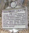
| Greenbrier County / Nicholas County in West Virginia Historical Markers A historical marker beside State Route 39/55 on the border of Greenbrier and Nicholas Counties, about 5 miles east of Richwood, West Virginia. posted by: Cache Sleuth location: West Virginia date approved: 04/21/2009 last visited: 08/27/2011 |
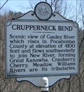 view gallery view gallerySW26.7 km | Crupperneck Bend in West Virginia Historical Markers A historical marker located beside a scenic overlook, just off State Route 20, that provides some spectacular views of a horseshoe bend in the Gauley River far below. posted by: Cache Sleuth location: West Virginia date approved: 04/15/2009 last visited: 03/26/2016 |
 view gallery view gallery SE26.7 km SE26.7 km
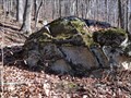
|  Honeycomb Rocks and Trail Honeycomb Rocks and Trail
in Places of Geologic Significance A group of interesting geologic formations located on a short, self guided trail. Handicapped accessible. posted by: woodhick803 location: West Virginia date approved: 11/15/2010 last visited: 06/24/2019 |
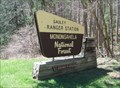 view gallery view galleryS26.9 km |  Monongahela National Forest - Gauley Ranger Station Monongahela National Forest - Gauley Ranger Station
in Ranger Stations Gauley Ranger Station is located along State Route 39, about one mile northeast of the city of Richwood, in Nicholas County, West Virginia. posted by: Cache Sleuth location: West Virginia date approved: 04/16/2009 last visited: 08/27/2011 |
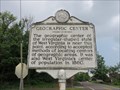 view gallery view galleryNW27.4 km | Geographic Center in West Virginia Historical Markers The geographic center of West Virginia. posted by: Paintedwarrior location: West Virginia date approved: 06/01/2015 last visited: never |
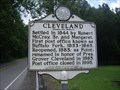 view gallery view galleryN27.7 km | Cleveland in West Virginia Historical Markers A sign with the same information on both sides telling us when the area was settled and how it received its name. posted by: Paintedwarrior location: West Virginia date approved: 07/28/2013 last visited: 08/01/2013 |
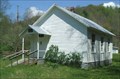 view gallery view galleryNW27.8 km |  Windy Run Grade School - Braxton County, WV Windy Run Grade School - Braxton County, WV
in U.S. National Register of Historic Places One-room school house built in 1889, located in a quiet valley in southeastern Braxton County, near the unincorporated town of Tesla, West Virginia. posted by: Cache Sleuth location: West Virginia date approved: 04/30/2009 last visited: 03/21/2014 |
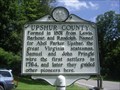 view gallery view galleryN28.2 km | Upshur / Webster County in West Virginia Historical Markers A two sided sign telling us when and from where the two counties where formed. posted by: Paintedwarrior location: West Virginia date approved: 07/28/2013 last visited: 08/01/2013 |
 view gallery view gallerySW28.5 km | Calvin, WV. 26660 in U.S. Post Offices Calvin WV Post Office posted by: dukemartin location: West Virginia date approved: 08/15/2012 last visited: never |
 view gallery view gallerySW28.5 km |  Tri-Rivers Rail Trail Tri-Rivers Rail Trail
in Mountain Bike Trailheads The Tri-Rivers Rail Trail is a hiking and biking path that runs 17 miles from Richwood, WV along the Cherry, Gauley and Cranberry Rivers.
posted by:  ScienceCacher ScienceCacher location: West Virginia date approved: 09/07/2005 last visited: 04/04/2009 |
 view gallery view galleryS29.5 km | Richwood, WV - 26261 in U.S. Post Offices Main post office building for Richwood, a small city located in eastern Nicholas County, West Virginia. posted by: Cache Sleuth location: West Virginia date approved: 04/05/2009 last visited: 08/27/2011 |
 view gallery view gallerySE29.5 km |  Big Spruce Overlook - Highland Scenic Drive of Monongahela National Forest - Marlinton, West Virginia Big Spruce Overlook - Highland Scenic Drive of Monongahela National Forest - Marlinton, West Virginia
in Scenic Roadside Look-Outs The Big Spruce Overlook is one of four Scenic Overlooks of the Highland Scenic Drive of the Monongahela National Forest in Pocahontas County, West Virginia posted by: outdoorboy34 location: West Virginia date approved: 06/30/2012 last visited: 10/03/2023 |
|