 view gallery view gallery S4.2 km S4.2 km
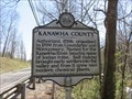
|   Kanawha County / Putnam County Kanawha County / Putnam County
in West Virginia Historical Markers A double sided sign that tells where the counties were formed from. posted by:  dukemartin dukemartin location: West Virginia date approved: 04/09/2018 last visited: 04/09/2018 |
 view gallery view gallery NW4.5 km NW4.5 km
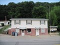
|  Bancroft, WV Post Office - 25011 Bancroft, WV Post Office - 25011
in U.S. Post Offices This post office is located at 14 Main St in Bancroft, WV which is in Putnam County. posted by: VQ9JC location: West Virginia date approved: 08/24/2013 last visited: never |
 view gallery view gallery SW4.7 km SW4.7 km
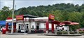
|  Checkers - 1st Ave. - Nitro, WV Checkers - 1st Ave. - Nitro, WV
in Burger Shops - Regional Chains Checkers located in Nitro, West Virginia just northwest of the state capital. posted by: bobfrapples8 location: West Virginia date approved: 09/12/2023 last visited: never |
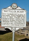 view gallery view gallerySW5.6 km | Battle of Scary in West Virginia Historical Markers Battle of Scary, Putnam Co., WV posted by:  two-bit Joe two-bit Joe location: West Virginia date approved: 02/18/2007 last visited: 05/23/2013 |
 view gallery view galleryS5.8 km |  Formerly Tri-State Racetrack and Gaming Center, now Mardi Gras Casino and Resort - Nitro WV Formerly Tri-State Racetrack and Gaming Center, now Mardi Gras Casino and Resort - Nitro WV
in Wikipedia Entries The facility was opened in 1985, as Tri-State Racetrack and Gaming Center, focusing specifically on greyhound racing. Slot machines were added in 2002. I visited the site on May 30, 2005. posted by: Don.Morfe location: West Virginia date approved: 01/23/2024 last visited: 01/24/2024 |
 view gallery view galleryS5.8 km |  Formerly Tri-State Racetrack and Gaming Center, now Mardi Gras Casino and Resort - Nitro WV Formerly Tri-State Racetrack and Gaming Center, now Mardi Gras Casino and Resort - Nitro WV
in Casinos The facility was opened in 1985, as Tri-State Racetrack and Gaming Center, focusing specifically on greyhound racing. Slot machines were added in 2002. I visited the site on May 30, 2005. posted by: Don.Morfe location: West Virginia date approved: 01/23/2024 last visited: 01/24/2024 |
 view gallery view galleryS5.8 km |  Mardi Gras Casino and Resort - Nitro WV Mardi Gras Casino and Resort - Nitro WV
in Recommended Accommodation The facility was opened in 1985, as Tri-State Racetrack and Gaming Center, focusing specifically on greyhound racing. Slot machines were added in 2002. We stayed at their 150-room luxury hotel on May 30, 2005. posted by: Don.Morfe location: West Virginia date approved: 01/24/2024 last visited: 01/24/2024 |
 S6.8 km |  Comfort Inn Cross Lanes, WV Comfort Inn Cross Lanes, WV
in Wi-Fi Hotspots Free wireless available at Comfort Inn in Cross Lanes. posted by: Man In The Wild location: West Virginia date approved: 09/11/2005 last visited: 11/18/2011 |
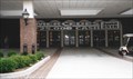
 view gallery view galleryS6.8 km |  American Red Cross - Charleston, WV USA American Red Cross - Charleston, WV USA
in Red Cross and Red Crescent Movement Red Cross building located in Charleston, West Virginia. posted by: bobfrapples8 location: West Virginia date approved: 09/17/2023 last visited: never |
 view gallery view gallerySW6.9 km | Kanawha County/Putnam County in West Virginia Historical Markers Kanawha County/Putnam County Line posted by: two-bit Joe location: West Virginia date approved: 02/27/2007 last visited: 05/20/2013 |
 view gallery view galleryS7.1 km |  TGI Friday's - Cross Lanes, WV TGI Friday's - Cross Lanes, WV
in TGI Friday's Restaurants This TGI Friday's is located just northwest of Charleston in Cross Lanes, West Virginia. posted by: bobfrapples8 location: West Virginia date approved: 09/06/2023 last visited: never |
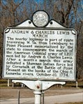 view gallery view galleryNW7.2 km | Andrew & Charles Lewis March in West Virginia Historical Markers Andrew & Charles Lewis March, Putnam Co., WV posted by: two-bit Joe location: West Virginia date approved: 02/24/2007 last visited: 08/18/2017 |
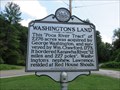 view gallery view galleryNW7.2 km | Washington's Land in West Virginia Historical Markers Describes a Tract of land purchased by George Washington. posted by: dukemartin location: West Virginia date approved: 08/22/2017 last visited: 08/22/2017 |
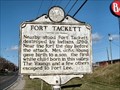 view gallery view gallerySW9 km | Fort Tackett in West Virginia Historical Markers Fort Tackett, Kanawha Co., WV posted by: two-bit Joe location: West Virginia date approved: 02/27/2007 last visited: 05/20/2013 |
 view gallery view galleryS9.5 km | Washington's Land in West Virginia Historical Markers George Washington's "Cole" River Tract of 2,000 acres was surveyed by John Floyd in 1774 and patented April 12, 1774. Bounded by the Coal and Kanawha Rivers, "5 miles and 88 poles", it embraced the site of St. Albans posted by: two-bit Joe location: West Virginia date approved: 08/17/2006 last visited: 02/04/2017 |
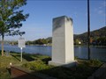 view gallery view galleryS9.5 km |  American Creed War Memorial – St. Albans, West Virginia American Creed War Memorial – St. Albans, West Virginia
in Non-Specific Veteran Memorials This memorial dedicated to the people who have defended our Nation's Freedom, is located on land once granted to and owned by President George Washington at St. Albans, West Virginia. posted by: PersonsMD location: West Virginia date approved: 06/01/2013 last visited: 10/17/2012 |
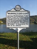 view gallery view galleryS9.5 km | Washington's Land in West Virginia Historical Markers A marker noting the land boundaries of a land patent issued to President George Washington. Located on the southern boundary of his estate the marker is found on the bank of the Kanawha River. posted by: PersonsMD location: West Virginia date approved: 05/29/2013 last visited: 02/04/2017 |
 view gallery view galleryS9.5 km |  St. Albans Roadside Park - St. Albans, West Virginia St. Albans Roadside Park - St. Albans, West Virginia
in Public Playgrounds A quiet roadside playground located in the St. Albans Roadside Park set on the flat banks of the Kanawha River on land once owned by President George Washington. Offers old school swings and great views of the river. posted by: PersonsMD location: West Virginia date approved: 05/30/2013 last visited: 10/17/2012 |
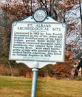 view gallery view galleryS9.7 km | St. Albans Archeological Site in West Virginia Historical Markers Archeological Site. Located on US 60 West St. Albans posted by: two-bit Joe location: West Virginia date approved: 08/28/2006 last visited: 02/04/2017 |
 view gallery view galleryNW9.7 km | Winfield in West Virginia Historical Markers Winfield, Putnam Co., WV posted by: two-bit Joe location: West Virginia date approved: 02/18/2007 last visited: 08/18/2017 |
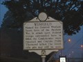
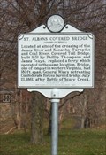 view gallery view galleryS10 km | St. Albans Covered Bridge in West Virginia Historical Markers Located at site of the crossing of the James River and Kanawha Turnpike and Coal River. Covered Toll Bridge, built 1831 by Phillip Thompson and James Teays, replaced a ferry which operated in the same location. Bridge, one of longest in western Virginia, had 180 ft. span. General Wise's retreating Confederate forces burned bridge July 21, 1861, after Battle of Scary Creek.
Location: Along roadway in front of McKinley Jr. High, Kanawha Terrace, St. Albans
posted by: two-bit Joe location: West Virginia date approved: 08/17/2006 last visited: 02/18/2017 |
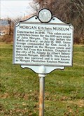 view gallery view galleryS10 km | Morgan Kitchen Museum in West Virginia Historical Markers Morgan Kitchen Museum, located US 60 West(MacCorkle Avenue), 1.8 miles east of Sattes Bridge, St Albans. posted by: two-bit Joe location: West Virginia date approved: 08/25/2006 last visited: 08/10/2013 |
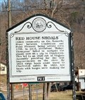 view gallery view galleryNW10.5 km | Red House Shoals/Civil War Action in West Virginia Historical Markers Dual marker Putnam County, WV posted by: two-bit Joe location: West Virginia date approved: 02/19/2007 last visited: 08/18/2017 |
 view gallery view galleryS10.5 km | Institute WV 25112 Post Office in U.S. Post Offices Institute WV Post Office posted by: dukemartin location: West Virginia date approved: 03/05/2017 last visited: never |
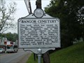 view gallery view galleryS10.6 km | Bangor Cemetery in West Virginia Historical Markers Bangor Cemetery located in St. Albans posted by: two-bit Joe location: West Virginia date approved: 01/09/2009 last visited: 02/18/2017 |
|