 view gallery view gallery NE3.1 km NE3.1 km
|   Marysvale, Utah Marysvale, Utah
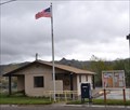
in Wikipedia Entries Marysvale is a small community of less than 400 inhabitants at the southwest corner of Piute County. posted by:  brwhiz brwhiz location: Utah date approved: 06/11/2011 last visited: never |
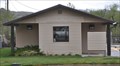
 view gallery view galleryNE3.1 km |  Marysvale, Utah 84750 Marysvale, Utah 84750
in U.S. Post Offices The small Marysvale Post Office serves about 180 households in its ZIP Code area from its location at 100 W 200 North. posted by: brwhiz location: Utah date approved: 06/11/2011 last visited: never |
 view gallery view gallery E3.1 km E3.1 km
|  Marysvale Bell Marysvale Bell
in Bells In 1864 several families of Latter-day Saints settled in this valley but were forced to evacuate because of Indian troubles. Here in 1868 miners discovered precious metal and took possession of the area... posted by: JacobBarlow location: Utah date approved: 09/06/2007 last visited: 05/09/2011 |
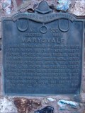 view gallery view galleryE3.1 km |  Marysvale Marysvale
in Utah Historical Markers In 1864 several families of Latter-day Saints settled in this valley but were forced to evacuate because of Indian troubles. Here in 1868 miners discovered precious metal and took possession of the area... posted by: JacobBarlow location: Utah date approved: 09/03/2007 last visited: 05/09/2011 |
 view gallery view galleryE3.1 km |  First LDS Bishop of Marysvale First LDS Bishop of Marysvale
in First of its Kind Charles C. Pinny was the first LDS bishop of Marysvale, Utah. posted by: brwhiz location: Utah date approved: 06/17/2011 last visited: never |
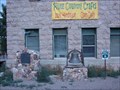
 view gallery view galleryE3.1 km |  Marysvale ~ 320 Marysvale ~ 320
in D.U.P. Historic Markers Settled originally in 1864, Marysvale was abandoned until the end of the Black Hawk War. posted by: brwhiz location: Utah date approved: 06/18/2011 last visited: never |
 view gallery view galleryE3.1 km | Marysvale School Bell in Utah Historical Markers This bell originally graced the roof of the Marysvale Public School. posted by: brwhiz location: Utah date approved: 07/01/2011 last visited: 07/03/2016 |
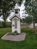 view gallery view galleryE3.2 km |  The Marysvale Bell Tower - Marysvale, UT The Marysvale Bell Tower - Marysvale, UT
in Bell Towers This little bell tower was constructed to show case a bell of historic importance to the community. posted by: rjmcdonough1 location: Utah date approved: 08/28/2021 last visited: never |
 view gallery view galleryNE4.7 km |  M is for Marysvale, Utah M is for Marysvale, Utah
in Letters on Hills Open block M on the hill to the east of Marysvale. posted by: Jokeerus location: Utah date approved: 10/09/2021 last visited: never |
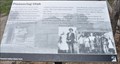 view gallery view gallery N16.4 km N16.4 km
| Pioneering Utah in Utah Historical Markers This Historical Marker is located on the south side of Clear Creek Canyon Road, just west of Sam Stowe Canyon Road and about 0.6 miles east of the Fremont Indian State Park Visitor Center near Sevier, Utah. posted by: brwhiz location: Utah date approved: 03/13/2013 last visited: never |
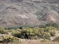
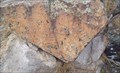
 view gallery view galleryN16.4 km |  The Arch of Art The Arch of Art
in Pictographs These Pictographs are located on the north side of Clear Creek Canyon Road, a short distance east of Fremont Indian State Park Museum and Visitor Center between Sevier and Marysvale, Utah. posted by: brwhiz location: Utah date approved: 03/25/2013 last visited: never |
 view gallery view galleryN16.6 km | Freemont Indian Pictographs - Freemont Indian State Park, Sevier, UT in Pictographs This Freemont Indian pictorgaph is on displahy outside the Visitors Center of Freemont Indian State Park - in Sevier, Utah. posted by: The Snowdog location: Utah date approved: 01/28/2023 last visited: never |
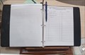 view gallery view galleryN16.6 km |  Freemont Indian State Park Guest Book - Sevier, UT Freemont Indian State Park Guest Book - Sevier, UT
in Guest Books The guest book for Freemont Indian State Park is at the desk in the Visitors Center - in Sevier, Utah. posted by: The Snowdog location: Utah date approved: 01/03/2023 last visited: never |
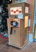 view gallery view galleryN16.6 km |  Freemont Indian State Park Penny Smasher - Sevier, UT Freemont Indian State Park Penny Smasher - Sevier, UT
in Penny Smashers This Penny Smasher is just inside the entrance of the Freemont Indian State Park Visitors Center - in Sevier, Utah. posted by: The Snowdog location: Utah date approved: 01/04/2023 last visited: never |
 view gallery view galleryN16.6 km |  Candy Mountain Express Northern Trailhead Candy Mountain Express Northern Trailhead
in Rails to Trails This Trailhead for the Candy Mountain Express Rail to Trails path is located at Sevier Junction, where US Highway 89 and Utah Highway 70 meet on the north side of the very small community of Sevier, Utah. posted by: brwhiz location: Utah date approved: 03/22/2013 last visited: never |
 view gallery view galleryN16.6 km |  Candy Mountain Express Northern Trailhead Candy Mountain Express Northern Trailhead
in Hiking and walking trailheads This Trailhead for the Candy Mountain Express biking/hiking trail is located at Sevier Junction, where US Highway 89 and Utah Highway 70 meet on the north side of the very small community of Sevier, Utah. posted by: brwhiz location: Utah date approved: 03/22/2013 last visited: never |
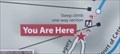 view gallery view galleryN16.6 km |  You Are Here - Court of Ceremonies Trail - Sevier, UT You Are Here - Court of Ceremonies Trail - Sevier, UT
in 'You Are Here' Maps This You-Are-Here map is your guide to the trails of Freemont Indian State Park - in Sevier, Utah. posted by: The Snowdog location: Utah date approved: 01/03/2023 last visited: never |
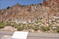
 view gallery view gallery NW16.9 km NW16.9 km
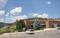
|  Fremont Indian State Park - Utah Fremont Indian State Park - Utah
in State/Provincial Parks Fremont Indian State Park is located at 3820 W Clear Creek Canyon Road near Sevier, Utah. posted by: brwhiz location: Utah date approved: 04/09/2013 last visited: 01/03/2023 |
 view gallery view galleryNW16.9 km |  Fremont Indian State Park Visitor Center Fremont Indian State Park Visitor Center
in Ranger Stations This Ranger Station is located at 3820 W Clear Creek Canyon Road near Sevier, Utah. posted by: brwhiz location: Utah date approved: 03/13/2013 last visited: 01/03/2023 |
 view gallery view gallery S20.4 km S20.4 km
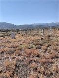
|  Harris Cemetery - Junction, Utah, USA Harris Cemetery - Junction, Utah, USA
in Worldwide Cemeteries Visit this tiny cemetery off Hwy 89 near Junction. posted by: Jokeerus location: Utah date approved: 10/08/2021 last visited: never |
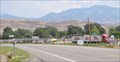 view gallery view galleryN20.8 km |  Diamond D Travel Plaza Diamond D Travel Plaza
in Truck Stops This Truck Stop is located just east of the Interstate Highway 70 Exit 25 interchange on the west side of Joseph, Utah. posted by: brwhiz location: Utah date approved: 03/13/2013 last visited: never |
 view gallery view galleryN21.1 km | Old Church Bell in Bells This Bell is mounted on top of a brick monument in front of the Old Church Vacation Rental at the northeast corner of State Street and 100 North in Joseph, Utah. posted by: brwhiz location: Utah date approved: 03/13/2013 last visited: never |
 view gallery view galleryN21.1 km |  1929 - Old Church Vacation Rental ~ Elsinore, Utah 1929 - Old Church Vacation Rental ~ Elsinore, Utah
in Dated Buildings and Cornerstones This Cornerstone is part of the Old Church Vacation Rental at the northeast corner of State Street and 100 North in Joseph, Utah. posted by: brwhiz location: Utah date approved: 03/13/2013 last visited: never |
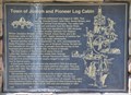
 view gallery view galleryN21.1 km | Town of Joseph and Pioneer Log Cabin ~ 478 in D.U.P. Historic Markers This Daughters of Utah Pioneers Historical Marker is mounted on a brick monument in the park at about 135 N 100 East in Joseph, Utah. posted by: brwhiz location: Utah date approved: 11/17/2012 last visited: never |
 view gallery view galleryN21.1 km |  Town of Joseph, Utah and Pioneer Log Cabin ~ USA Town of Joseph, Utah and Pioneer Log Cabin ~ USA
in Human Migration Monuments It took three tries before a permanent settlement was established for Joseph City, Utah, named after a son of Church President Brigham Young. posted by: brwhiz location: Utah date approved: 11/15/2012 last visited: never |
|