 view gallery view gallery S0.2 km S0.2 km
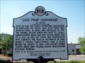
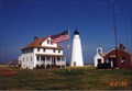
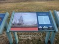
|   Cove Point Lighthouse Cove Point Lighthouse
in Maryland Historical Markers This historical marker sits along Cove Point Road, about 150 yards east of Rte 4. There is a park & ride very nearby so viewing this one is plenty safe. posted by:  redlights redlights location: Maryland date approved: 06/18/2008 last visited: 03/22/2009 |
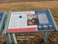
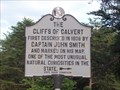 view gallery view gallery NW0.6 km NW0.6 km
| The CLIFFS of CALVERT in Maryland Historical Markers This historical marker is right at the front gate of Calvert Cliffs State Park. The park itself has lots of great trails that lead down to the cliffs themselves. posted by: redlights location: Maryland date approved: 07/01/2008 last visited: 07/01/2022 |
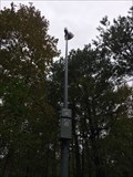 view gallery view gallery N1 km N1 km
|  ASE Warning Siren - Calvert, MD ASE Warning Siren - Calvert, MD
in Outdoor Warning Sirens An ASE warning siren for the nearby nuclear power plant in Calvert Cliffs State Park. posted by: bluesnote location: Maryland date approved: 11/24/2018 last visited: 11/24/2018 |
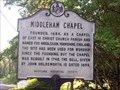 view gallery view galleryN1 km | Middleham Chapel in Maryland Historical Markers This historic marker sits along side of Rte. 765 leading towards Lusby, MD. You can park along the road or pull into the lot nearby. posted by: redlights location: Maryland date approved: 06/18/2008 last visited: 11/19/2013 |
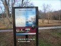
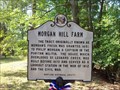 view gallery view galleryNW2.7 km | MORGAN HILL FARM in Maryland Historical Markers This historical marker sits at the junction of Sollers Wharf Road and Wohlgemuth Road in southern Calvert County. posted by: redlights location: Maryland date approved: 07/11/2008 last visited: never |
 view gallery view galleryNW3.5 km | Preston on Patuxent in Maryland Historical Markers Preston on Patuxent, this historical marker is located on Pardoe Rd, in Calvert County, MD. posted by: redlights location: Maryland date approved: 06/19/2008 last visited: never |
 view gallery view gallery E4.5 km E4.5 km
|  Cove Point Lighthouse Cove Point Lighthouse
in Coastal Lighthouses The Cove Point Lighthouse is open to the public during certain times of the year. Click this link below to view the schedule on the Calvert Marine Museum's site. posted by: redlights location: Maryland date approved: 05/22/2008 last visited: 07/09/2011 |
 view gallery view gallery SW5.1 km SW5.1 km
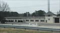
|  Solomons Vol. Rescue Squad & Fire Dept. Solomons Vol. Rescue Squad & Fire Dept.
in Firehouses A fire station in Solomons, Maryland. posted by: bluesnote location: Maryland date approved: 12/20/2021 last visited: never |
 view gallery view gallerySW5.1 km |  Solomons Volunteer Rescue Squad Fire Department Flagpole - Solomons, MD Solomons Volunteer Rescue Squad Fire Department Flagpole - Solomons, MD
in Nautical Flag Poles A nautical flagpole at the Solomons Volunteer Rescue Squad Fire Department in Solomons, Maryland. posted by: bluesnote location: Maryland date approved: 12/28/2021 last visited: never |
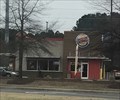 view gallery view gallerySW5.5 km |  Burger King - H. G. Trueman Rd. - Solomons, MD Burger King - H. G. Trueman Rd. - Solomons, MD
in Burger King Restaurants A Burger King in Solomons, Maryland. posted by: bluesnote location: Maryland date approved: 12/22/2021 last visited: never |
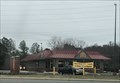 view gallery view gallerySW5.6 km |  McDonald's - H. G. Trueman Rd. - Solomons, MD McDonald's - H. G. Trueman Rd. - Solomons, MD
in McDonald's Restaurants A McDonald's in Solomons, Maryland. posted by: bluesnote location: Maryland date approved: 12/20/2021 last visited: never |
 view gallery view gallery W6.4 km W6.4 km
|  Land Battle Evidence - Saint Leonard MD Land Battle Evidence - Saint Leonard MD
in Signs of History In 2000, archaeologists at Jefferson Patterson Park and Museum examined three areas, including the hill directly ahead. The research was funded by the National Park Service’s American Battlefield Protection Program. posted by:  Don.Morfe Don.Morfe location: Maryland date approved: 04/02/2020 last visited: 09/27/2021 |
 view gallery view galleryW6.4 km |  “The Commodore Can Beat Any…Barges…Sent Against Him” - Saint Leonard MD “The Commodore Can Beat Any…Barges…Sent Against Him” - Saint Leonard MD
in War of 1812 “The Commodore Can Beat Any…Barges…Sent Against Him” Maryland Republican, June 18, 1814 posted by: Don.Morfe location: Maryland date approved: 04/03/2020 last visited: 11/02/2021 |
 view gallery view galleryW6.4 km | “The Commodore Can Beat Any…Barges…Sent Against Him” - Saint Leonard MD in Signs of History “The Commodore Can Beat Any…Barges…Sent Against Him” Maryland Republican, June 18, 1814 posted by: Don.Morfe location: Maryland date approved: 09/02/2022 last visited: 09/03/2022 |
 view gallery view galleryW6.4 km |  “The Commodore Can Beat Any…Barges…Sent Against Him” - Saint Leonard MD “The Commodore Can Beat Any…Barges…Sent Against Him” - Saint Leonard MD
in Battlefields The marker is located on the grounds of Jefferson Patterson Park and Museum at Jefferson Patterson Park Road, Saint Leonard, MD USA 20685 posted by: Don.Morfe location: Maryland date approved: 09/19/2023 last visited: 09/19/2023 |
 view gallery view galleryW6.4 km | Valor at St. Leonard Creek - Saint Leonard MD in War of 1812 Valor at St. Leonard Creek
Letters from Commodore Joshua Barney posted by: Don.Morfe location: Maryland date approved: 04/03/2020 last visited: 11/02/2021 |
 view gallery view galleryW6.4 km | Valor at St. Leonard Creek - Saint Leonard MD in Signs of History Valor at St. Leonard Creek Letters from Commodore Joshua Barney posted by: Don.Morfe location: Maryland date approved: 09/02/2022 last visited: 09/03/2022 |
 view gallery view galleryW6.4 km | Valor at St. Leonard Creek - Saint Leonard MD in Battlefields The marker is located on the grounds of Jefferson Patterson Park and Museum at Jefferson Patterson Park Road, Saint Leonard, MD USA 20685 posted by: Don.Morfe location: Maryland date approved: 09/19/2023 last visited: 09/19/2023 |
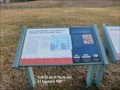
 view gallery view galleryW6.4 km | John Stuart Skinner - Saint Leonard MD in War of 1812 John Stuart Skinner Witness to Fort’s Bombardment-
“Ruffian, Patriot, and Philanthropist…”
John Quincy Adams. posted by: Don.Morfe location: Maryland date approved: 04/03/2020 last visited: 11/02/2021 |
 view gallery view galleryW6.4 km | John Stuart Skinner - Saint Leonard MD in Signs of History John Stuart Skinner Witness to Fort’s Bombardment- “Ruffian, Patriot, and Philanthropist…” John Quincy Adams. posted by: Don.Morfe location: Maryland date approved: 09/02/2022 last visited: 09/03/2022 |
 view gallery view galleryW6.4 km | John Stuart Skinner-Witness to Fort’s Bombardment - Saint Leonard MD in Battlefields Marker is at the Jefferson Patterson Park and Museum on Jefferson Patterson Park Road, Saint Leonard, MD USA 20685. (Because of his actions, Skinner’s property which is now the site of Jefferson Patterson Park and Museum was burned by the British.) posted by: Don.Morfe location: Maryland date approved: 09/18/2023 last visited: 09/19/2023 |
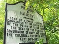
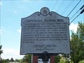 view gallery view galleryS6.4 km | Amphibious Training Base in Maryland Historical Markers Amphibious Training Base. The historical marker is displayed along the side of Dowell Road, just before entering Calvert Marina. posted by: redlights location: Maryland date approved: 06/19/2008 last visited: 07/09/2011 |
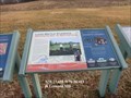
 view gallery view galleryW6.4 km | Fate of the Flotilla Star-Spangled Banner National Historic Trail - Saint Leonard MD in War of 1812 Some of the fiercest fighting of the war occurred here, where St. Leonard Creek meets the Patuxent River. During the summer of 1814, the British navy tried to flush out and destroy Commodore Joshua Barney’s Chesapeake Flotilla. posted by: Don.Morfe location: Maryland date approved: 03/22/2020 last visited: 11/02/2021 |
 view gallery view galleryW6.4 km | Fate of the Flotilla Star-Spangled Banner National Historic Trail - Saint Leonard MD in Signs of History Some of the fiercest fighting of the war occurred here, where St. Leonard Creek meets the Patuxent River. During the summer of 1814, the British navy tried to flush out and destroy Commodore Joshua Barney’s Chesapeake Flotilla. posted by: Don.Morfe location: Maryland date approved: 09/02/2022 last visited: 09/03/2022 |
 view gallery view galleryW6.4 km | Fate of the Flotilla - Saint Leonard MD in Battlefields The marker is on Jefferson Patterson Park Road, Saint Leonard MD, United States 20685. posted by: Don.Morfe location: Maryland date approved: 09/14/2023 last visited: 09/14/2023 |
|