 view gallery view gallery E4.3 km E4.3 km
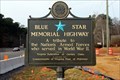
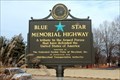
|   US 301, Dahlgren Wayside Park, Dahlgren, VA US 301, Dahlgren Wayside Park, Dahlgren, VA
in Blue Star Memorial Highway Markers Located on the Virginia side of the Potomac River posted by:  Markerman62 Markerman62 location: Virginia date approved: 02/04/2021 last visited: 01/20/2021 |
 view gallery view gallery W6.6 km W6.6 km
|  Caledon State Park - King George, VA Caledon State Park - King George, VA
in Wikipedia Entries Caledon State Park is located at 11617 Caledon Road, King George, VA USA 22485. posted by:  Don.Morfe Don.Morfe location: Virginia date approved: 09/21/2023 last visited: 09/22/2023 |
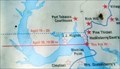
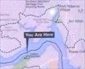 view gallery view galleryW6.6 km |  'You Are Here' Maps-All that Glitters Captain - King George, VA 'You Are Here' Maps-All that Glitters Captain - King George, VA
in 'You Are Here' Maps The 'You Are Here' Maps-All that Glitters shows that you are at Caledon State Park, 11617 Caledon Road, King George, VA USA 22485 posted by: Don.Morfe location: Virginia date approved: 09/21/2023 last visited: 09/22/2023 |
 view gallery view galleryW6.6 km | 'You Are Here' Maps-Join the Adventure-Captain John Smith Chesapeake National Historic Trail - King George, VA in 'You Are Here' Maps The 'You Are Here' Maps-All that Glitters shows that you are at Caledon State Park, 11617 Caledon Road, King George, VA USA 22485 posted by: Don.Morfe location: Virginia date approved: 09/21/2023 last visited: 09/22/2023 |
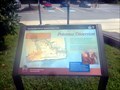
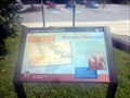
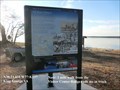 view gallery view galleryW6.6 km |  All that Glitters Captain John Smith Chesapeake National Historic Trail - King George, VA - All that Glitters Captain John Smith Chesapeake National Historic Trail - King George, VA -
in Signs of History When John Smith and his crew explored the Potomac River in 1608, they were looking for a passageway to the Pacific and for precious metals. They heard about a black ore with silvery glitters, which they hoped contained silver. posted by: Don.Morfe location: Virginia date approved: 01/21/2020 last visited: 09/25/2021 |
 view gallery view galleryW7.1 km |  Caledon State Park - King George, VA Caledon State Park - King George, VA
in Satellite Imagery Oddities Caledon State Park is located at 11617 Caledon Rd., King George, VA 22485 posted by: Don.Morfe location: Virginia date approved: 09/22/2023 last visited: 09/22/2023 |
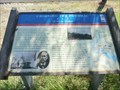
 view gallery view galleryW7.1 km |  Smoot House Visitor Center-Caledon State Park-Circa 1910 - King George, VA Smoot House Visitor Center-Caledon State Park-Circa 1910 - King George, VA
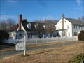
in Dated Architectural Structures Multifarious Smoot House Visitor Center Circa 1910 located at 11617 Caledon Rd., King George, VA 22485 posted by: Don.Morfe location: Virginia date approved: 09/22/2023 last visited: 09/22/2023 |
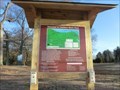
 view gallery view galleryW7.1 km |  Smoot House Visitor Center-Caledon State Park - King George, VA Smoot House Visitor Center-Caledon State Park - King George, VA
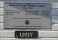
in Tourist Information Centers - Visitor Centers The Visitor Center at Caledon State Park is located at 11617 Caledon Rd., King George, VA 22485 posted by: Don.Morfe location: Virginia date approved: 09/23/2023 last visited: 09/23/2023 |
 view gallery view galleryW7.1 km |  Caledon State Park - King George, VA Caledon State Park - King George, VA
in Official Local Tourism Attractions Caledon State Park is located at 11617 Caledon Rd., King George, VA 22485 posted by: Don.Morfe location: Virginia date approved: 09/23/2023 last visited: 09/23/2023 |
 view gallery view galleryW7.1 km |  Caledon State Park - King George, VA Caledon State Park - King George, VA
in State/Provincial Parks Caledon State Park is located at 11617 Caledon Rd., King George, VA 22485 posted by: Don.Morfe location: Virginia date approved: 09/22/2023 last visited: 09/22/2023 |
 view gallery view gallery SW7.6 km SW7.6 km
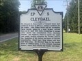
|  Cleydael Cleydael
in Virginia Historical Markers On VA 206 at Cleydael Boulevard, King George posted by: Markerman62 location: Virginia date approved: 07/09/2023 last visited: never |
 view gallery view galleryE7.9 km | US 301, Potomac River Bridge Toll Gate, Newburg, MD in Blue Star Memorial Highway Markers Located on the Maryland side of the Potomac River posted by: Markerman62 location: Maryland date approved: 02/04/2021 last visited: 01/20/2021 |
 view gallery view gallery NE8 km NE8 km
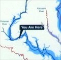
| 'You Are Here' Maps - Crossing the Potomac Off into the Darkness - Newburg MD in 'You Are Here' Maps The 'You Are Here' Map shows where John Wilkes Booth crossed the Potomac after assassinating President Abraham Lincoln. posted by: Don.Morfe location: Maryland date approved: 05/04/2024 last visited: never |
 view gallery view galleryNE8 km |  Crossing the Potomac Off into the Darkness - Newburg MD Crossing the Potomac Off into the Darkness - Newburg MD
in Civil War Discovery Trail Sites After assassinating President Abraham Lincoln on April 14, 1865, John Wilkes Booth and his accomplice, David A. Herold, fled Washington for Southern Maryland. posted by: Don.Morfe location: Maryland date approved: 03/11/2020 last visited: 10/08/2021 |
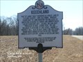 view gallery view galleryNE8.7 km |  Keechland Keechland
in Maryland Historical Markers Keechland-Part of large tract reserved as public land by Cecilius Calvert, Lord Baltimore. posted by: Don.Morfe location: Maryland date approved: 10/29/2019 last visited: 09/28/2021 |
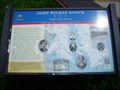 view gallery view galleryE9.3 km | John Wilkes Booth in Civil War Discovery Trail Sites John Wilkes Booth; Escape of an Assassin; War on the Chesapeake Bay. posted by: garmin_geek location: Maryland date approved: 05/26/2009 last visited: 01/18/2019 |
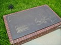 view gallery view galleryE9.3 km |  Crain Memorial Travel Center, Newburg, MD Crain Memorial Travel Center, Newburg, MD
in Direction and Distance Arrows This bronze memorial map has direction and distance arrows to Maryland cities. posted by: garmin_geek location: Maryland date approved: 10/19/2009 last visited: 08/08/2022 |
 view gallery view galleryE9.3 km | Potomac Diversion Star-Spangled Banner National Historic Trail - Newburg, MD in Signs of History British vessels labored through Kettle Bottom Shoals near here in August 1814 during a diversionary expedition up the Potomac. posted by: Don.Morfe location: Maryland date approved: 08/30/2022 last visited: 08/30/2022 |
 view gallery view galleryE9.3 km |  Potomac Diversion Star-Spangled Banner National Historic Trail - Newburg, MD Potomac Diversion Star-Spangled Banner National Historic Trail - Newburg, MD
in War of 1812 British vessels labored through Kettle Bottom Shoals near here in August 1814 during a diversionary expedition up the Potomac. posted by: Don.Morfe location: Maryland date approved: 03/06/2020 last visited: 11/02/2021 |
 view gallery view galleryE9.3 km |  Maryland Welcome Center Electric Car Charging Station - Newburg, MD Maryland Welcome Center Electric Car Charging Station - Newburg, MD
in Electric Car Charging Stations This car charging station is located in the middle of the parking lot. posted by: bluesnote location: Maryland date approved: 08/04/2012 last visited: 04/24/2015 |
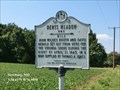 view gallery view galleryNE9.7 km | Dents Meadow-one mile in Maryland Historical Markers Dents Meadow One mile- John Wilkes Booth and David Herold set out from here for the Virginia shore. posted by: Don.Morfe location: Maryland date approved: 10/29/2019 last visited: 09/21/2021 |
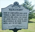 view gallery view galleryNE10.5 km | "Huckleberry" in Maryland Historical Markers "Huckleberry"-Home of Confederate Mail Agent, Thomas A. Jones, posted by: Don.Morfe location: Maryland date approved: 10/29/2019 last visited: 09/21/2021 |
 view gallery view gallerySW11.3 km | Ralph Bunche High School in Virginia Historical Markers School opened in 1949 to satisfy equalization of segregated school facilities. posted by: Markerman62 location: Virginia date approved: 08/08/2021 last visited: never |
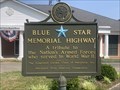 view gallery view galleryNE11.6 km | Maryland Veterans Memorial Museum - Newburg, MD in Blue Star Memorial Highway Markers An older Blue Star Memorial Highway in Newburg, MD posted by: Markerman62 location: Maryland date approved: 07/09/2023 last visited: never |
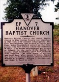 view gallery view gallerySW11.6 km | Hanover Baptist Church in Virginia Historical Markers A marker for the oldest Baptist Church in King George County. posted by: Markerman62 location: Virginia date approved: 03/22/2015 last visited: 03/29/2015 |
|