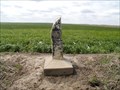
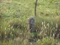
 view gallery view gallery NW17.5 km NW17.5 km
|   Homestead of a genius Homestead of a genius
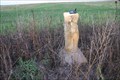
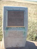
in Kansas Historical Markers One of the world's most important scientists, George Washington Carver, spent his formative years in Kansas. posted by:  azswade azswade location: Kansas date approved: 12/16/2010 last visited: 10/06/2017 |
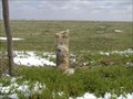
 view gallery view gallery S37.5 km S37.5 km
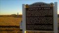
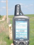
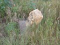
|  N 38 W 100 ~ SW of Jetmore, Kansas N 38 W 100 ~ SW of Jetmore, Kansas
in Confluence Spots This point of intersection for 38 degrees north latitude and 100 degrees west longitude occurs along a rural road north of Dodge City and a few miles southwest of Jetmore, Kansas. posted by:  brwhiz brwhiz location: Kansas date approved: 05/30/2012 last visited: 08/30/2019 |
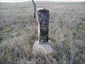
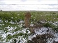
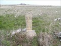
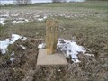
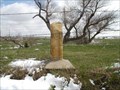
 view gallery view gallery N57 km N57 km
|  BOD marker on 200 Ave. Trego BOD marker on 200 Ave. Trego
in Butterfield Overland Despatch Markers The marker is approx. 160 feet north of U Rd. and 200 Ave. posted by: Bridgerdigger location: Kansas date approved: 09/09/2007 last visited: 04/04/2010 |
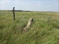
 view gallery view galleryN57.3 km | BOD Marker on 220 Ave. Trego in Butterfield Overland Despatch Markers This BOD Marker is approx. 350 ft. south of U Rd. and 220 Ave. posted by: Bridgerdigger location: Kansas date approved: 09/09/2007 last visited: 05/26/2012 |
 view gallery view galleryNW57.3 km | BOD S21-T15S-R28W in Butterfield Overland Despatch Markers This marker is in good condition except for some chipping around the letters. It is located on the west side of the county road. posted by: Kansas Stasher location: Kansas date approved: 10/29/2007 last visited: never |
 view gallery view galleryN57.8 km | BOD Marker near U Rd and 240 Ave in Butterfield Overland Despatch Markers This marker is south of U Rd. and 240 Ave., Trego posted by: Bridgerdigger location: Kansas date approved: 09/09/2007 last visited: 05/01/2010 |
 view gallery view galleryN57.9 km | Cove 4 Rd BOD Marker in Butterfield Overland Despatch Markers This BOD marker is on the north side of Cedar Bluff Res. It is .9 mile south of 270 and U RD. posted by: Bridgerdigger location: Kansas date approved: 08/10/2007 last visited: 10/17/2010 |
 view gallery view galleryN58.3 km | Cedar Bluff Wildlife Area Rd. in Butterfield Overland Despatch Markers This BOD marker is 1/2 mile north of 260 and V Rd. It is on the north side of Cedar Bluff Res. north of the wildlife area. posted by: Bridgerdigger location: Kansas date approved: 08/10/2007 last visited: 10/17/2010 |
 view gallery view galleryN58.3 km | BOD 8-14-24 in Butterfield Overland Despatch Markers Found marker in good condition. posted by: Kansas Stasher location: Kansas date approved: 04/07/2007 last visited: 05/26/2012 |
 view gallery view galleryN58.4 km | BOD 6-14-24 in Butterfield Overland Despatch Markers Marker in leaning and has unstable dirt under it. Limestone plaque is dislodged and has a corner broken off. posted by: Kansas Stasher location: Kansas date approved: 04/07/2007 last visited: 05/26/2012 |
 view gallery view galleryN58.7 km | Castle Rock Road BOD Marker in Butterfield Overland Despatch Markers This BOD Marker is in Gove County at the intersection of Castle Rock Road and Go K. posted by: Bridgerdigger location: Kansas date approved: 02/18/2008 last visited: 05/17/2014 |
 view gallery view galleryN58.9 km | BOD 1-14-25 in Butterfield Overland Despatch Markers Found marker in good condition. posted by: Kansas Stasher location: Kansas date approved: 04/07/2007 last visited: 05/26/2012 |
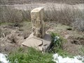
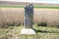
 view gallery view gallery NE58.9 km NE58.9 km
| Cove 2-3 Road BOD Marker in Butterfield Overland Despatch Markers This BOD marker is on the north side of Cedar Bluff Lake. posted by: Bridgerdigger location: Kansas date approved: 08/10/2007 last visited: 08/30/2008 |
 view gallery view galleryNE59.2 km | Church Camp Road BOD Marker in Butterfield Overland Despatch Markers This BOD marker is on the north/south road leading into the church camp, Dream Camp, and north shore cabins north of Cedar Bluff Reservoir. The BOD marker is north of where the road splits to go to these locations. posted by: Bridgerdigger location: Kansas date approved: 07/02/2007 last visited: never |
 view gallery view galleryN59.4 km | BOD 3-14-25 in Butterfield Overland Despatch Markers Marker found in good condition. posted by: Kansas Stasher location: Kansas date approved: 04/07/2007 last visited: 05/26/2012 |
 view gallery view galleryN59.5 km | BOD 2-14-25 in Butterfield Overland Despatch Markers Marker found in good condition. posted by: Kansas Stasher location: Kansas date approved: 04/07/2007 last visited: 05/26/2012 |
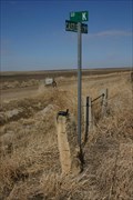
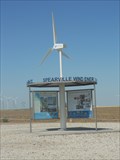 view gallery view gallery SE59.7 km SE59.7 km
|  Spearville Wind Energy Facility - Spearville, KS Spearville Wind Energy Facility - Spearville, KS
in Windmills The Spearville Wind Energy Facility is a 5,000-acre windmill farm in Spearville, Kansas, USA. posted by: Marine Biologist location: Kansas date approved: 11/19/2011 last visited: never |
 view gallery view galleryN59.9 km | BOD 5-14-25 in Butterfield Overland Despatch Markers Marker found in good condition. posted by: Kansas Stasher location: Kansas date approved: 04/07/2007 last visited: 05/26/2012 |
 view gallery view galleryNE60 km | BOD Marker on highway 147 east of Cedar Bluff Dam in Butterfield Overland Despatch Markers This BOD marker is on highway 147 just east of the Cedar Bluff Dam. posted by: Bridgerdigger location: Kansas date approved: 10/24/2007 last visited: 04/30/2010 |
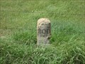
 view gallery view gallerySE60.2 km |  Spearville, Kansas 67876 Spearville, Kansas 67876
in U.S. Post Offices This Post Office is located at 302 Main Street in Spearville, Kansas. posted by: brwhiz location: Kansas date approved: 09/01/2012 last visited: never |
 view gallery view galleryNW60.2 km | BOD Marker on Highway 23 in Butterfield Overland Despatch Markers This BOD marker is on Highway 23, .12 miles north of Rd. D and about .5 miles north of the Smoky Hill River. posted by: Bridgerdigger location: Kansas date approved: 04/21/2008 last visited: never |
 view gallery view galleryN60.7 km | BOD 31-13-25 in Butterfield Overland Despatch Markers Marker found in good condition. posted by: Kansas Stasher location: Kansas date approved: 04/07/2007 last visited: 05/14/2014 |
 view gallery view galleryN60.8 km | BOD 32-13-25 in Butterfield Overland Despatch Markers Marker found in good condition. Located on a dead end road. posted by: Kansas Stasher location: Kansas date approved: 04/07/2007 last visited: never |
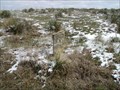
 view gallery view galleryS61.5 km |  Santa Fe Trail - Howell Trail Ruts Santa Fe Trail - Howell Trail Ruts
in Wagon Roads and Trails This is a two mile section of Santa Fe Trail Ruts located 1/2 mile west of Howell, Kansas on US-50. Site has been listed as a Historic Landmark. posted by: iconions location: Kansas date approved: 12/01/2008 last visited: 01/05/2023 |
 view gallery view galleryS61.5 km |  Santa Fe Trail Ruts - near Howell, Kansas Santa Fe Trail Ruts - near Howell, Kansas
in U.S. National Register of Historic Places This is a two mile section of Santa Fe Trail Ruts located 1/2 mile west of Howell, Kansas on US-50. posted by: iconions location: Kansas date approved: 12/02/2008 last visited: 01/05/2023 |
|