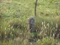
 view gallery view gallery NW28.3 km NW28.3 km
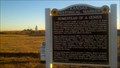
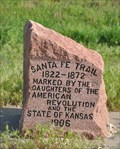
|   Homestead of a genius Homestead of a genius
in Kansas Historical Markers One of the world's most important scientists, George Washington Carver, spent his formative years in Kansas. posted by:  azswade azswade location: Kansas date approved: 12/16/2010 last visited: 10/06/2017 |
 view gallery view gallery S34.3 km S34.3 km
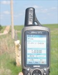
|  N 38 W 100 ~ SW of Jetmore, Kansas N 38 W 100 ~ SW of Jetmore, Kansas
in Confluence Spots This point of intersection for 38 degrees north latitude and 100 degrees west longitude occurs along a rural road north of Dodge City and a few miles southwest of Jetmore, Kansas. posted by:  brwhiz brwhiz location: Kansas date approved: 05/30/2012 last visited: 08/30/2019 |
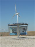 view gallery view galleryS52.3 km |  Spearville Wind Energy Facility - Spearville, KS Spearville Wind Energy Facility - Spearville, KS
in Windmills The Spearville Wind Energy Facility is a 5,000-acre windmill farm in Spearville, Kansas, USA. posted by: Marine Biologist location: Kansas date approved: 11/19/2011 last visited: never |
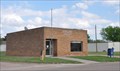
 view gallery view galleryS52.9 km |  Spearville, Kansas 67876 Spearville, Kansas 67876
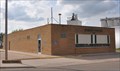
in U.S. Post Offices This Post Office is located at 302 Main Street in Spearville, Kansas. posted by: brwhiz location: Kansas date approved: 09/01/2012 last visited: never |
 view gallery view gallery SE56.5 km SE56.5 km
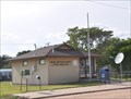
| Offerle, Kansas 67563 in U.S. Post Offices This Post Office is located at 116 S Main Street in Offerle, Kansas. posted by: brwhiz location: Kansas date approved: 09/01/2012 last visited: never |
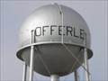 view gallery view gallerySE56.5 km |  Water Tower - Offerle KS Water Tower - Offerle KS
in Water Towers This water tower is just north of Hwy 50 in Offerle, Kansas. posted by: PeterNoG location: Kansas date approved: 02/14/2011 last visited: 04/29/2012 |
 view gallery view gallerySE56.5 km |  HG1000 ~ OFFERLE MUN WATER TANK HG1000 ~ OFFERLE MUN WATER TANK
in U.S. Benchmarks This benchmark is the top center of the municipal water tank in Offerle, Kansas. posted by: brwhiz location: Kansas date approved: 05/30/2012 last visited: 12/27/2010 |
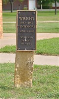
 view gallery view galleryS58.4 km |  Wright Senior Center Wright Senior Center
in Municipal Community Centers This Senior Center is located at 10891 Main Street in Wright, Kansas. posted by: brwhiz location: Kansas date approved: 02/04/2013 last visited: never |
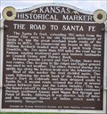 view gallery view galleryS58.4 km |  The Road to Santa Fe The Road to Santa Fe
in Wagon Roads and Trails This Kansas Historical Marker is located in a turnout on the northeast corner of the intersection of Jewell Road (US Highway 283) and 117 Road (US Highway 50/56) about 8 miles northeast of Dodge City, Kansas. posted by: brwhiz location: Kansas date approved: 02/04/2013 last visited: never |
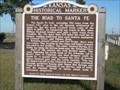 view gallery view galleryS58.4 km | The Road to Santa Fe - Ford County in Kansas Historical Markers This marker is in a roadside turnout 8 miles northeast of Dodge City, Kansas on US-56, US-50, and US-283. posted by: iconions location: Kansas date approved: 12/01/2008 last visited: 05/01/2005 |
 view gallery view galleryS58.4 km |  Wright, Kansas Centennial Wright, Kansas Centennial
in Community Commemoration This centennial marker is located near the northwest corner of the Wright post office located at 10894 Main Street in Wright, Kansas. posted by: brwhiz location: Kansas date approved: 02/09/2013 last visited: never |
 view gallery view galleryS58.4 km | Wright, Kansas 67882 in U.S. Post Offices This Post Office is located at 10894 Main Street in Wright, Kansas. posted by: brwhiz location: Kansas date approved: 09/01/2012 last visited: never |
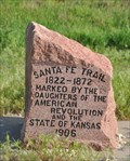 view gallery view gallerySE58.6 km | Santa Fe Trail in Kansas Historical Markers This engraved stone marker for the Santa Fe Trail is located in a turnout on the south side of US Highway 50/56 west of Kinsley, Kansas. posted by: brwhiz location: Kansas date approved: 02/06/2013 last visited: never |
 view gallery view gallerySE58.6 km | Santa Fe Trail at Kinsley, Kansas in Wagon Roads and Trails This engraved stone marker for the Santa Fe Trail is located in a turnout on the south side of US Highway 50/56 west of Kinsley, Kansas. posted by: brwhiz location: Kansas date approved: 02/22/2013 last visited: never |
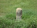
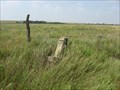
 view gallery view gallery N58.6 km N58.6 km
|  BOD Marker on highway 147 east of Cedar Bluff Dam BOD Marker on highway 147 east of Cedar Bluff Dam
in Butterfield Overland Despatch Markers This BOD marker is on highway 147 just east of the Cedar Bluff Dam. posted by: Bridgerdigger location: Kansas date approved: 10/24/2007 last visited: 04/30/2010 |
 view gallery view galleryN58.7 km | Church Camp Road BOD Marker in Butterfield Overland Despatch Markers This BOD marker is on the north/south road leading into the church camp, Dream Camp, and north shore cabins north of Cedar Bluff Reservoir. The BOD marker is north of where the road splits to go to these locations. posted by: Bridgerdigger location: Kansas date approved: 07/02/2007 last visited: never |
 view gallery view galleryN58.7 km | Cove 4 Rd BOD Marker in Butterfield Overland Despatch Markers This BOD marker is on the north side of Cedar Bluff Res. It is .9 mile south of 270 and U RD. posted by: Bridgerdigger location: Kansas date approved: 08/10/2007 last visited: 10/17/2010 |
 view gallery view galleryN58.9 km | Cove 2-3 Road BOD Marker in Butterfield Overland Despatch Markers This BOD marker is on the north side of Cedar Bluff Lake. posted by: Bridgerdigger location: Kansas date approved: 08/10/2007 last visited: 08/30/2008 |
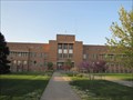 view gallery view galleryS59.1 km |  Hennessy Hall, Saint Mary of the Plains Campus - Dodge City, Kansas Hennessy Hall, Saint Mary of the Plains Campus - Dodge City, Kansas
in U.S. National Register of Historic Places Historic former college building in Dodge City, Kansas posted by:  BruceS BruceS location: Kansas date approved: 06/07/2012 last visited: never |
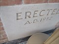 view gallery view galleryS59.1 km |  1952 - Hennessy Hall, Saint Mary of the Plains Campus - Dodge City, Kansas 1952 - Hennessy Hall, Saint Mary of the Plains Campus - Dodge City, Kansas
in Dated Buildings and Cornerstones Historic former college building in Dodge City, Kansas posted by: BruceS location: Kansas date approved: 06/06/2012 last visited: never |
 view gallery view galleryN59.4 km | Cedar Bluff Wildlife Area Rd. in Butterfield Overland Despatch Markers This BOD marker is 1/2 mile north of 260 and V Rd. It is on the north side of Cedar Bluff Res. north of the wildlife area. posted by: Bridgerdigger location: Kansas date approved: 08/10/2007 last visited: 10/17/2010 |
 view gallery view galleryN59.5 km | BOD Marker near U Rd and 240 Ave in Butterfield Overland Despatch Markers This marker is south of U Rd. and 240 Ave., Trego posted by: Bridgerdigger location: Kansas date approved: 09/09/2007 last visited: 05/01/2010 |
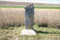
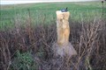
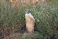
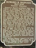 view gallery view gallery NE59.7 km NE59.7 km
| Howard R. Barnard - La Crosse, KS in Kansas Historical Markers This historical marker about Howard R. Barnard is located in Grass Park, a city park in La Crosse, Kansas. The agency responsible for placing the marker is not listed. posted by: Marine Biologist location: Kansas date approved: 08/16/2011 last visited: 05/04/2015 |
 view gallery view galleryN59.7 km | BOD Marker on 220 Ave. Trego in Butterfield Overland Despatch Markers This BOD Marker is approx. 350 ft. south of U Rd. and 220 Ave. posted by: Bridgerdigger location: Kansas date approved: 09/09/2007 last visited: 05/26/2012 |
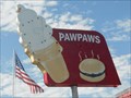 view gallery view galleryNE59.7 km |  Pawpaws - La Crosse, KS Pawpaws - La Crosse, KS
in Artistic Neon Lights Pawpaws' neon sign is missing all its neon tubes, but it's still an eye catcher in La Crosse, Kansas, USA. posted by: Marine Biologist location: Kansas date approved: 08/21/2011 last visited: never |
|