 view gallery view gallery NW13.4 km NW13.4 km
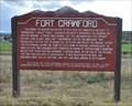
|   Fort Crawford ~ Montrose County, Colorado Fort Crawford ~ Montrose County, Colorado
in Colorado Historical Markers This Colorado Historical Marker is located on the southeast side of US Highway 550 about 7 miles south of Montrose, Colorado. posted by:  brwhiz brwhiz location: Colorado date approved: 02/14/2013 last visited: 01/24/2015 |
 view gallery view gallery S15 km S15 km
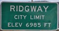
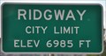
|  Ridgway, Colorado (Northern Approach) ~ Elevation 6985 Feet Ridgway, Colorado (Northern Approach) ~ Elevation 6985 Feet
in Elevation Signs This Elevation Sign is located on the northwest side of US Highway 550 at the northern town limit of Ridgeway, Colorado. posted by: brwhiz location: Colorado date approved: 02/12/2013 last visited: never |
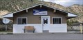
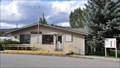 view gallery view galleryS16.3 km |  Ridgway, Colorado 81432 Ridgway, Colorado 81432
in U.S. Post Offices This Post Office is located at 485 Clinton Street in Ridgway, Colorado. posted by: brwhiz location: Colorado date approved: 10/31/2011 last visited: never |
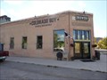
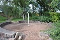
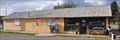 view gallery view galleryS16.3 km |  Ridgway Chamber of Commerce Visitor Center Ridgway Chamber of Commerce Visitor Center
in Tourist Information Centers - Visitor Centers This Tourist Information Center, operated by the Ridgeway Chamber of Commerce, is located at 150 Racecourse Road in Ridgway, Colorado. posted by: brwhiz location: Colorado date approved: 02/13/2013 last visited: 08/16/2014 |
 view gallery view galleryS16.3 km |  Colorado Boy Brewpub Colorado Boy Brewpub
in Brewpubs A pleasant surprise in the small town of Ridgway, Co. posted by: WalkingDuo location: Colorado date approved: 10/04/2009 last visited: 08/15/2014 |
 view gallery view galleryS16.4 km | Ridgway, Colorado (Southern Approach) ~ Elevation 6985 Feet in Elevation Signs This Elevation Sign is located on the east side of US Highway 550 at the southern town limit of Ridgeway, Colorado. posted by: brwhiz location: Colorado date approved: 02/12/2013 last visited: never |
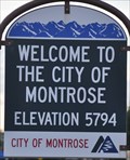 view gallery view galleryNW20.3 km | Montrose, Colorado (Southern Approach) ~ Elevation 5794 Feet in Elevation Signs This Elevation Sign is located on the east side of US Highway 550 at the southern city limit of Montrose, Colorado. posted by: brwhiz location: Colorado date approved: 02/12/2013 last visited: never |
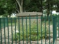
 view gallery view galleryNW21.1 km | The Dominguez-Escalante Expedition ~ Montrose, Colorado in Colorado Historical Markers This Colorado Historical Marker is located in Chipeta State Park at the intersection of US Highway 550 and Chepita Road on the southern edge of Montrose, Colorado. posted by: brwhiz location: Colorado date approved: 02/14/2013 last visited: never |
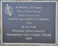
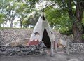 view gallery view galleryNW21.1 km |  Ouray and Chipeta's Spring Springhouse Ouray and Chipeta's Spring Springhouse
in Spring Houses This Springhouse, in the form of a teepee, is located just northwest of the intersection of US Highway 550 and Chepita Road in Chipeta State Park on the southern edge of Montrose, Colorado. posted by: brwhiz location: Colorado date approved: 02/14/2013 last visited: never |
 view gallery view galleryNW21.1 km |  Chipeta ~ Wife of Chief Ouray Chipeta ~ Wife of Chief Ouray
in Citizen Memorials This Citizen Memorial is located just northwest of the intersection of US Highway 550 and Chepita Road in Chipeta State Park on the southern edge of Montrose, Colorado. posted by: brwhiz location: Colorado date approved: 02/13/2013 last visited: never |
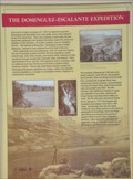
 view gallery view galleryNW21.1 km | Building An Empire: The Spanish Frontier ~ Montrose, Colorado in Colorado Historical Markers This Historical Marker about the Dominguez-Escalante Expedition of 1776-1777 is one of four located in Chipeta State Park at the intersection of US Highway 550 and Chepita Road on the southern edge of Montrose, Colorado. posted by: brwhiz location: Colorado date approved: 02/16/2013 last visited: never |
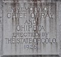 view gallery view galleryNW21.1 km | Chief Ouray and Chipeta in Citizen Memorials This Citizen Memorial is inscribed on an obelisk in the Chipeta State Park at the intersection of US Highway 550 and Chepita Road on the southern edge of Montrose, Colorado. posted by: brwhiz location: Colorado date approved: 02/14/2013 last visited: never |
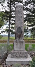 view gallery view galleryNW21.1 km |  Chief Ouray and Chipeta Memorial Obelisk ~ Montrose, Colorado Chief Ouray and Chipeta Memorial Obelisk ~ Montrose, Colorado
in Obelisks This Obelisk is located in Chipeta State Park at the intersection of US Highway 550 and Chepita Road on the southern edge of Montrose, Colorado. posted by: brwhiz location: Colorado date approved: 02/14/2013 last visited: never |
 view gallery view galleryNW21.1 km |  Montrose Peace Pole Montrose Peace Pole
in Peace Poles This Peace Pole is located at the intersection of US Highway 550 and Chepita Road and the entrance to Chipeta State Park on the southern edge of Montrose, Colorado. posted by: brwhiz location: Colorado date approved: 02/15/2013 last visited: never |
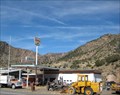 view gallery view gallery NE21.1 km NE21.1 km
|  Sinclair - Cimarron, CO Sinclair - Cimarron, CO
in Vintage Gas Stations This vintage gas station is located in Cimarron, CO. posted by:  Team Min Dawg Team Min Dawg location: Colorado date approved: 11/26/2008 last visited: 10/08/2011 |
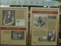
 view gallery view galleryNW21.2 km |  Ouray - Chipeta Park - Montrose, CO Ouray - Chipeta Park - Montrose, CO
in American Guide Series Chipeta was the wife of Ute chief Ouray. She, and Ouray, were champions of the Native American rights and treatment in the southwest. Her gravesite is here at Chipeta Park in Montrose, Colorado. posted by: 94RedRover location: Colorado date approved: 02/01/2009 last visited: 10/08/2011 |
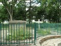
 view gallery view galleryNW21.2 km |  Chipeta, Montrose, CO Chipeta, Montrose, CO
in Grave of a Famous Person Chipeta was the wife of Ute chief Ouray. She, and Ouray, were champions of the Native American rights and treatment in the southwest. posted by: 94RedRover location: Colorado date approved: 08/03/2008 last visited: 10/08/2011 |
 view gallery view galleryNW21.2 km |  Ute Memorial Site - Montrose, CO Ute Memorial Site - Montrose, CO
in U.S. National Register of Historic Places On the land that was once the home of Ute Chief Ouray and his wife Chipeta, this marvelous museum is a look at the native American Ute Indian's culture. posted by: 94RedRover location: Colorado date approved: 12/07/2009 last visited: 10/08/2011 |
 view gallery view galleryNW21.2 km |  Ute Indian Museum, Montrose, CO Ute Indian Museum, Montrose, CO
in History Museums On the land that was once the home of Ute Chief Ouray and his wife Chipeta, this marvelous museum is a look at the native American Ute Indian's culture. posted by: 94RedRover location: Colorado date approved: 08/03/2008 last visited: 10/08/2011 |
 view gallery view gallery SE21.2 km SE21.2 km
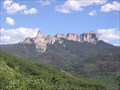
|  Courthouse Mountain Courthouse Mountain
in Mountain Summits A 4 mile rountrip hike up 1,790 feet, which requires some easy rock scrambling. The trail is located mostly inside the Uncompahgre Wilderness, so please follow wilderness rules. posted by: krazykatzen location: Colorado date approved: 08/04/2009 last visited: never |
 view gallery view galleryNE21.2 km | Cimarron, Colorado 81220 in U.S. Post Offices This Post Office is located at 82111 E US Highway 50 in Cimarron, Colorado. posted by: brwhiz location: Colorado date approved: 10/31/2011 last visited: 10/08/2011 |
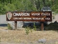 view gallery view galleryNE21.4 km | ") Curecanti National Recreation Area - Gunnison, Colorado Curecanti National Recreation Area - Gunnison, Colorado
in National Parks (U.S.) Curecanti National Recreation Area is near Black Canyon of the Gunnison National Park. posted by: paulspaper location: Colorado date approved: 05/05/2008 last visited: 05/11/2023 |
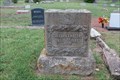 view gallery view galleryS21.7 km |  Clifford T. Rogers - Cedar Hill Cemetery - Ouray, CO Clifford T. Rogers - Cedar Hill Cemetery - Ouray, CO
in Woodmen of the World Grave Markers/Monuments Woodmen of the World headstone for Clifford T. Rogers, in Cedar Hill Cemetery, Ouray, CO. posted by: QuarrellaDeVil location: Colorado date approved: 09/26/2018 last visited: never |
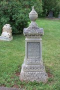 view gallery view galleryS21.7 km |  DeWitt C. Loudon - Cedar Hill Cemetery - Ouray, CO DeWitt C. Loudon - Cedar Hill Cemetery - Ouray, CO
in Zinc Headstones A zinc monument marks the final resting place of DeWitt C. Loudon, in Cedar Hill Cemetery, Ouray, CO. posted by: QuarrellaDeVil location: Colorado date approved: 10/11/2018 last visited: never |
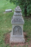 view gallery view galleryS21.7 km | Petter Johnson - Cedar Hill Cemetery - Ouray, CO in Zinc Headstones A zinc monument marks the final resting place of Petter Johnson, in Cedar Hill Cemetery, Ouray, CO. posted by: QuarrellaDeVil location: Colorado date approved: 10/11/2018 last visited: never |
|