 view gallery view gallery S2.7 km S2.7 km
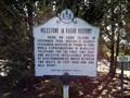
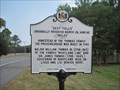
|   Milestone In Radio History Milestone In Radio History
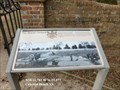
in Maryland Historical Markers Maryland Historical Highway Marker on Cobb Island. posted by:  garmin_geek garmin_geek location: Maryland date approved: 04/21/2013 last visited: 08/21/2021 |
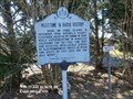 view gallery view galleryS2.7 km |  FIRST - Milestone in Radio History Marker - Cobb Island MD FIRST - Milestone in Radio History Marker - Cobb Island MD
in First of its Kind Here on Cobb Island, in December 1900, Reginald Aubrey Fessenden for the first time sent and received intelligible speech by electromagnetic waves between two masts 50 feet high and one mile apart. posted by: Don.Morfe location: Maryland date approved: 08/22/2021 last visited: 08/21/2021 |
 view gallery view gallery W10.3 km W10.3 km
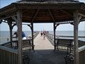
|  Colonial Beach Municipal Pier Colonial Beach Municipal Pier
in Piers Colonial Beach Municipal Pier on the Potomac River - Colonial Beach, Virginia posted by: Rivers End location: Virginia date approved: 05/28/2012 last visited: 09/17/2012 |
 view gallery view gallery NE10.8 km NE10.8 km
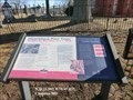
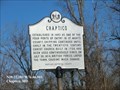
|  Prosperous Port Town Raided by British, July 1814 - Chaptico MD Prosperous Port Town Raided by British, July 1814 - Chaptico MD
in Signs of History Marker is locate at the intersection of Budd's Creek Road and Maddox Road, in front of Christ Church, Chaptico, MD United States 20621. posted by: Don.Morfe location: Maryland date approved: 09/12/2023 last visited: 09/12/2023 |
 view gallery view galleryNE10.8 km |  Prosperous Port Town Raided by British, July 1814 - Chaptico MD Prosperous Port Town Raided by British, July 1814 - Chaptico MD
in Battlefields Marker is locate at the intersection of Budd's Creek Road and Maddox Road, in front of Christ Church, Chaptico, MD United States 20621. posted by: Don.Morfe location: Maryland date approved: 09/12/2023 last visited: 09/12/2023 |
 view gallery view galleryNE10.8 km |  Prosperous Port Town Raided by British, July 1814 - Chaptico MD Prosperous Port Town Raided by British, July 1814 - Chaptico MD
in War of 1812 On July 30, 1814, the British landed at Chaptico's wharf and marched to Christ Church. Two different versions are told of their visit. posted by: Don.Morfe location: Maryland date approved: 04/05/2023 last visited: 04/04/2023 |
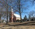 view gallery view galleryNE10.8 km |  Christ Episcopal Church (Chaptico, Maryland) Christ Episcopal Church (Chaptico, Maryland)
in Wikipedia Entries Christ Episcopal Church was constructed in 1736 of Flemish bond brick construction with glazed headers, 60 feet long and 40 feet wide. The building was heavily damaged on July 30, 1814, during the War of 1812. posted by: Don.Morfe location: Maryland date approved: 04/04/2023 last visited: 04/04/2023 |
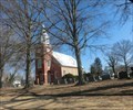
 view gallery view galleryNE10.8 km |  Christ Episcopal Church - Chaptico MD Christ Episcopal Church - Chaptico MD
in Anglican and Episcopal Churches Christ Episcopal Church was constructed in 1736 of Flemish bond brick construction with glazed headers, 60 feet long and 40 feet wide. The building was heavily damaged on July 30, 1814, during the War of 1812. posted by: Don.Morfe location: Maryland date approved: 04/04/2023 last visited: 04/04/2023 |
 view gallery view galleryNE10.8 km |  Christ Episcopal Church - Chaptico MD Christ Episcopal Church - Chaptico MD
in U.S. National Register of Historic Places Christ Episcopal Church is significant for its architecture,
which embodies the evolution of a typical parish church in
Maryland's rural southern region. posted by: Don.Morfe location: Maryland date approved: 04/05/2023 last visited: 04/04/2023 |
 view gallery view galleryNE10.8 km |  Christ Episcopal Church - Chaptico MD Christ Episcopal Church - Chaptico MD
in Official Local Tourism Attractions Christ Episcopal Church was constructed in 1736 of Flemish bond brick construction with glazed headers, 60 feet long and 40 feet wide. The building was heavily damaged on July 30, 1814, during the War of 1812. posted by: Don.Morfe location: Maryland date approved: 04/04/2023 last visited: 04/04/2023 |
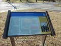
 view gallery view galleryNE10.9 km |  Chaptico-A History of Rebellion - Chaptico MD Chaptico-A History of Rebellion - Chaptico MD
in Civil War Discovery Trail Sites Tiny Chaptico was home to many daring men, beginning with John Coode who led Maryland's 1689 Protestant Rebellion. During the Civil War, Chaptico's blockade runners carried medicine and other supplies at night across the Potomac River. posted by: Don.Morfe location: Maryland date approved: 04/04/2023 last visited: 04/04/2023 |
 view gallery view galleryNE10.9 km | Chaptico-A History of Rebellion - Chaptico MD in U.S. Civil War Sites Tiny Chaptico was home to many daring men, beginning with John Coode who led Maryland's 1689 Protestant Rebellion. During the Civil War, Chaptico's blockade runners carried medicine and other supplies at night across the Potomac River. posted by: Don.Morfe location: Maryland date approved: 04/04/2023 last visited: 04/04/2023 |
 view gallery view galleryNE10.9 km | Chaptico-A History of Rebellion - Chaptico MD in Signs of History Marker is located at the intersection of Maddox Road (Maryland Route 238) and Chaptico Hurry Road, Chaptico , MD, United States 20621. posted by: Don.Morfe location: Maryland date approved: 09/12/2023 last visited: 09/12/2023 |
 view gallery view galleryNE10.9 km | Chaptico in Maryland Historical Markers Chaptico-Established in 1683 as one of the four ports of entry in St. Mary's County. posted by: Don.Morfe location: Maryland date approved: 10/25/2019 last visited: 09/28/2021 |
 view gallery view gallery SE11.1 km SE11.1 km
| Saint Clement's Island in Maryland Historical Markers Historical Marker located outside of the St. Clement's Island Museum. posted by:  flyingmoose flyingmoose location: Maryland date approved: 09/18/2020 last visited: 07/12/2014 |
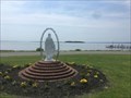 view gallery view gallerySE11.1 km |  Mary - Coltons Point, Maryland Mary - Coltons Point, Maryland
in Statues of Religious Figures Located in front of the St. Clement's Island Museum. posted by: flyingmoose location: Maryland date approved: 09/18/2020 last visited: 07/08/2018 |
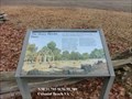
 view gallery view galleryNE11.1 km | Deep Falls in Maryland Historical Markers Historical marker about "Deep Falls", the 18th century home of the Thomas Family, the famous "Maryland Line". posted by: king.hubi location: Maryland date approved: 10/01/2010 last visited: 08/23/2021 |
 view gallery view gallery SW11.7 km SW11.7 km
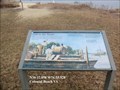
| Link to the World - Colonial Beach VA in Signs of History While the essentials of life could be had from the waters, fields, gardens, and forests of Popes Creek Plantation, true economic prosperity depended on the plantation's link to the world; the Potomac River. posted by: Don.Morfe location: Virginia date approved: 09/03/2020 last visited: 09/26/2021 |
 view gallery view gallerySW12.1 km | Henry Brooks Farm - Colonial Beach VA in Signs of History At the distant end of the field in front of you stood the home of Henry Brooks, the first owner of much of what would become Popes Creek Plantation. posted by: Don.Morfe location: Virginia date approved: 09/03/2020 last visited: 09/26/2021 |
 view gallery view gallerySE12.1 km |  Saint Clement's Island State Park - Religious Freedom - Coltons Point, Maryland Saint Clement's Island State Park - Religious Freedom - Coltons Point, Maryland
in National Scenic Byways Located off the coast of Maryland in the town of Coltons Point. posted by: flyingmoose location: Maryland date approved: 06/07/2021 last visited: 05/21/2023 |
 view gallery view gallerySW12.1 km | The John Washington House - Colonial Beach VA in Signs of History In 1664, John Washington, the great-grandfather of George Washington, built a small house on this site. From these modest beginnings, a powerful and prominent Virginia family would arise. posted by: Don.Morfe location: Virginia date approved: 09/03/2020 last visited: 09/26/2021 |
 view gallery view gallerySW12.1 km | The Burial Ground - Colonial Beach VA in Signs of History Three generations of George Washington’s forebears are buried here. The first burials were made in 1668, when John Washington’s wife Anne and two small children died. posted by: Don.Morfe location: Virginia date approved: 09/03/2020 last visited: 09/26/2021 |
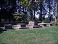 view gallery view gallerySW12.1 km |  Washington Family Cemetery - Westmoreland County, VA Washington Family Cemetery - Westmoreland County, VA
in Worldwide Cemeteries The Washington Family burial grounds (Cemetery) is located at the George Washington Birthplace National Monument in Westmoreland County, VA. posted by: Lat34North location: Virginia date approved: 09/13/2007 last visited: 01/12/2024 |
 view gallery view gallerySW12.4 km |  George Washington Family Coats of Arms George Washington Family Coats of Arms
in Coats of Arms Coats of arms of George Washington's ancestral families posted by: jonathanatpsu location: Virginia date approved: 07/27/2017 last visited: never |
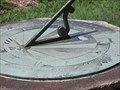 view gallery view gallerySW12.6 km |  George Washington Birthplace National Monument George Washington Birthplace National Monument
in Sundials This sundial is located in the rose garden at the "George Washington Birthplace National Monument". posted by: Lat34North location: Virginia date approved: 09/07/2007 last visited: 12/03/2012 |
|