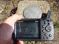
 view gallery view gallery SE6.6 km SE6.6 km
|   Monroe Hall BM Monroe Hall BM
in U.S. Benchmarks Not in the dbase.
posted by:  tiki-4 tiki-4 location: Virginia date approved: 11/20/2005 last visited: 09/17/2012 |
 view gallery view gallerySE6.6 km |  James Monroe James Monroe
in Presidential Birthplaces His two terms in office, sometimes called the Era of Good Feelings, were generally a period of national optimism, growth, and expansion for the United States.
posted by: tiki-4 location: Virginia date approved: 09/09/2005 last visited: 02/21/2013 |
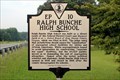 view gallery view gallery W7.1 km W7.1 km
|  Ralph Bunche High School Ralph Bunche High School
in Virginia Historical Markers School opened in 1949 to satisfy equalization of segregated school facilities. posted by: Markerman62 location: Virginia date approved: 08/08/2021 last visited: never |
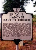 view gallery view galleryW7.2 km | Hanover Baptist Church in Virginia Historical Markers A marker for the oldest Baptist Church in King George County. posted by: Markerman62 location: Virginia date approved: 03/22/2015 last visited: 03/29/2015 |
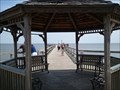 view gallery view gallery E8.5 km E8.5 km
|  Colonial Beach Municipal Pier Colonial Beach Municipal Pier
in Piers Colonial Beach Municipal Pier on the Potomac River - Colonial Beach, Virginia posted by:  Rivers End Rivers End location: Virginia date approved: 05/28/2012 last visited: 09/17/2012 |
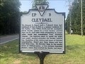 view gallery view gallery NW8.5 km NW8.5 km
| Cleydael in Virginia Historical Markers On VA 206 at Cleydael Boulevard, King George posted by: Markerman62 location: Virginia date approved: 07/09/2023 last visited: never |
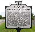 view gallery view gallery SW9.2 km SW9.2 km
| Historic Port Conway in Virginia Historical Markers The site of Port Conway on the Rappahannock River. posted by: Taluss location: Virginia date approved: 09/26/2008 last visited: 08/08/2021 |
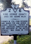 view gallery view gallery S9.7 km S9.7 km
| King George County/Westmoreland County in Virginia Historical Markers A county line marker southeast of King George. posted by: Markerman62 location: Virginia date approved: 03/25/2015 last visited: 03/29/2015 |
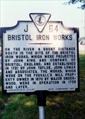 view gallery view galleryS10 km | Bristol Iron Works in Virginia Historical Markers A marker about an iron works that was located on the Rappahannock. posted by: Markerman62 location: Virginia date approved: 03/25/2015 last visited: 03/29/2015 |
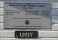 view gallery view galleryNW10.3 km |  Smoot House Visitor Center-Caledon State Park-Circa 1910 - King George, VA Smoot House Visitor Center-Caledon State Park-Circa 1910 - King George, VA
in Dated Architectural Structures Multifarious Smoot House Visitor Center Circa 1910 located at 11617 Caledon Rd., King George, VA 22485 posted by: Don.Morfe location: Virginia date approved: 09/22/2023 last visited: 09/22/2023 |
 view gallery view galleryNW10.3 km |  Caledon State Park - King George, VA Caledon State Park - King George, VA
in Satellite Imagery Oddities Caledon State Park is located at 11617 Caledon Rd., King George, VA 22485 posted by: Don.Morfe location: Virginia date approved: 09/22/2023 last visited: 09/22/2023 |
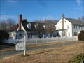 view gallery view galleryNW10.3 km |  Smoot House Visitor Center-Caledon State Park - King George, VA Smoot House Visitor Center-Caledon State Park - King George, VA
in Tourist Information Centers - Visitor Centers The Visitor Center at Caledon State Park is located at 11617 Caledon Rd., King George, VA 22485 posted by: Don.Morfe location: Virginia date approved: 09/23/2023 last visited: 09/23/2023 |
 view gallery view galleryNW10.3 km |  Caledon State Park - King George, VA Caledon State Park - King George, VA
in Official Local Tourism Attractions Caledon State Park is located at 11617 Caledon Rd., King George, VA 22485 posted by: Don.Morfe location: Virginia date approved: 09/23/2023 last visited: 09/23/2023 |
 view gallery view galleryNW10.3 km |  Caledon State Park - King George, VA Caledon State Park - King George, VA
in State/Provincial Parks Caledon State Park is located at 11617 Caledon Rd., King George, VA 22485 posted by: Don.Morfe location: Virginia date approved: 09/22/2023 last visited: 09/22/2023 |
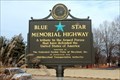
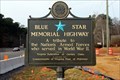 view gallery view gallery N10.3 km N10.3 km
|  US 301, Dahlgren Wayside Park, Dahlgren, VA US 301, Dahlgren Wayside Park, Dahlgren, VA
in Blue Star Memorial Highway Markers Located on the Virginia side of the Potomac River posted by: Markerman62 location: Virginia date approved: 02/04/2021 last visited: 01/20/2021 |
 view gallery view gallerySE10.9 km | Westmoreland Association in Virginia Historical Markers The Stamp Act was a tax imposed by the British on the colonies, requiring printed materials be produced on stamped paper produced in London. The sign is about the protests of this tax. posted by: nomadwillie location: Virginia date approved: 10/18/2013 last visited: 04/02/2001 |
 view gallery view gallerySE10.9 km | History of Oak Grove in Virginia Historical Markers George Washington went to school nearby among other bits of history. posted by: Markerman62 location: Virginia date approved: 03/22/2015 last visited: 03/29/2015 |
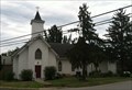 view gallery view galleryW11.7 km |  Saint Anthony of Padua - King George, VA Saint Anthony of Padua - King George, VA
in This Old Church St. Anthony of Padua Church, built in 1917 in King George, VA posted by: jonathanatpsu location: Virginia date approved: 03/04/2022 last visited: never |
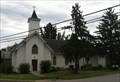 view gallery view galleryW11.7 km | Saint Anthony of Padua - King George, VA in Roman Catholic Churches St. Anthony of Padua Church in King George, VA posted by: jonathanatpsu location: Virginia date approved: 07/27/2017 last visited: never |
 view gallery view gallery NE12.4 km NE12.4 km
| US 301, Potomac River Bridge Toll Gate, Newburg, MD in Blue Star Memorial Highway Markers Located on the Maryland side of the Potomac River posted by: Markerman62 location: Maryland date approved: 02/04/2021 last visited: 01/20/2021 |
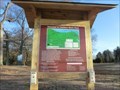
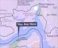 view gallery view galleryNW12.7 km |  'You Are Here' Maps-All that Glitters Captain - King George, VA 'You Are Here' Maps-All that Glitters Captain - King George, VA
in 'You Are Here' Maps The 'You Are Here' Maps-All that Glitters shows that you are at Caledon State Park, 11617 Caledon Road, King George, VA USA 22485 posted by: Don.Morfe location: Virginia date approved: 09/21/2023 last visited: 09/22/2023 |
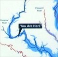 view gallery view galleryNW12.7 km | 'You Are Here' Maps-Join the Adventure-Captain John Smith Chesapeake National Historic Trail - King George, VA in 'You Are Here' Maps The 'You Are Here' Maps-All that Glitters shows that you are at Caledon State Park, 11617 Caledon Road, King George, VA USA 22485 posted by: Don.Morfe location: Virginia date approved: 09/21/2023 last visited: 09/22/2023 |
 view gallery view galleryNW12.7 km |  Caledon State Park - King George, VA Caledon State Park - King George, VA
in Wikipedia Entries Caledon State Park is located at 11617 Caledon Road, King George, VA USA 22485. posted by: Don.Morfe location: Virginia date approved: 09/21/2023 last visited: 09/22/2023 |
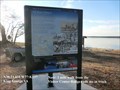 view gallery view galleryNW12.7 km |  All that Glitters Captain John Smith Chesapeake National Historic Trail - King George, VA - All that Glitters Captain John Smith Chesapeake National Historic Trail - King George, VA -
in Signs of History When John Smith and his crew explored the Potomac River in 1608, they were looking for a passageway to the Pacific and for precious metals. They heard about a black ore with silvery glitters, which they hoped contained silver. posted by: Don.Morfe location: Virginia date approved: 01/21/2020 last visited: 09/25/2021 |
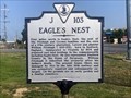 view gallery view galleryW12.9 km | Eagle's Nest in Virginia Historical Markers One of a group of three markers posted by: Markerman62 location: Virginia date approved: 07/09/2023 last visited: never |
|