 view gallery view gallery SW37.7 km SW37.7 km
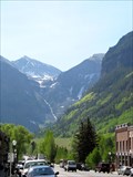
|   "Festival Capital of the Rockies" - Telluride, Colorado "Festival Capital of the Rockies" - Telluride, Colorado
in 1000 Places to See Before You Die Increasingly known as "Festival Capital of the Rockies", Telluride is one of Colorado's most beautiful areas posted by:  Outspoken1 Outspoken1 location: Colorado date approved: 01/23/2011 last visited: 09/14/2019 |
 view gallery view gallery NE55.8 km NE55.8 km
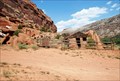
|  Captain Smith's Cabin Captain Smith's Cabin
in Homesteads Rock cabin built in Escalante Canyon by Captain Henry A. Smith in 1911. posted by:  MSDJ23 MSDJ23 location: Colorado date approved: 12/02/2009 last visited: 05/31/2015 |
 view gallery view gallery W57.5 km W57.5 km
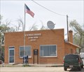
|  La Sal, Utah 84530 La Sal, Utah 84530
in Wikipedia Entries La Sal is a small community of about 340 inhabitants in the northeast corner of San Juan County. posted by: brwhiz location: Utah date approved: 06/11/2011 last visited: never |
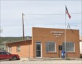 view gallery view galleryW57.5 km |  La Sal, Utah 84530 La Sal, Utah 84530
in U.S. Post Offices The small La Sal Post Office serves only about 70 households from its location at 2 Main Street. posted by: brwhiz location: Utah date approved: 06/12/2011 last visited: never |
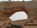 view gallery view galleryW67.4 km |  Wilson Arch Wilson Arch
in Natural Arches A spectacular arch right next to Highway 191, formerly called Highway 163 according to my old Mapsource Topo maps. posted by: Miragee location: Utah date approved: 06/25/2006 last visited: 10/20/2014 |
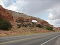 view gallery view galleryW67.4 km | Wilson arch in Wikipedia Entries Wilson Arch, has a span of 91 feet and height of 46 feet, and is located about 24 miles south of Moab, Utah on US 191. The arch is visible from the road. There is a pulloff on the east with interpretive signs. posted by: JacobBarlow location: Utah date approved: 07/25/2007 last visited: 10/20/2014 |
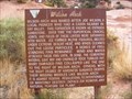 view gallery view galleryW67.6 km |  Wilson Arch - Monticello UT Wilson Arch - Monticello UT
in Utah Historical Markers "Wilson Arch was named after Joe Wilson, a local pioneer who had a cabin nearby in Dry Valley. This formation is known as Entrada Sandstone. Over time superficial cracks, joints, and folds of these layers were saturated with water." posted by: Don.Morfe location: Utah date approved: 08/05/2022 last visited: 10/20/2014 |
 view gallery view gallery E67.8 km E67.8 km
|  Chipeta, Montrose, CO Chipeta, Montrose, CO
in Grave of a Famous Person Chipeta was the wife of Ute chief Ouray. She, and Ouray, were champions of the Native American rights and treatment in the southwest. posted by: 94RedRover location: Colorado date approved: 08/03/2008 last visited: 10/08/2011 |
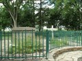
 view gallery view galleryE67.8 km |  Ute Memorial Site - Montrose, CO Ute Memorial Site - Montrose, CO
in U.S. National Register of Historic Places On the land that was once the home of Ute Chief Ouray and his wife Chipeta, this marvelous museum is a look at the native American Ute Indian's culture. posted by: 94RedRover location: Colorado date approved: 12/07/2009 last visited: 10/08/2011 |
 view gallery view galleryE67.8 km |  Ute Indian Museum, Montrose, CO Ute Indian Museum, Montrose, CO
in History Museums On the land that was once the home of Ute Chief Ouray and his wife Chipeta, this marvelous museum is a look at the native American Ute Indian's culture. posted by: 94RedRover location: Colorado date approved: 08/03/2008 last visited: 10/08/2011 |
 view gallery view galleryE67.8 km |  Ouray - Chipeta Park - Montrose, CO Ouray - Chipeta Park - Montrose, CO
in American Guide Series Chipeta was the wife of Ute chief Ouray. She, and Ouray, were champions of the Native American rights and treatment in the southwest. Her gravesite is here at Chipeta Park in Montrose, Colorado. posted by: 94RedRover location: Colorado date approved: 02/01/2009 last visited: 10/08/2011 |
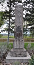 view gallery view galleryE67.8 km |  Chief Ouray and Chipeta Memorial Obelisk ~ Montrose, Colorado Chief Ouray and Chipeta Memorial Obelisk ~ Montrose, Colorado
in Obelisks This Obelisk is located in Chipeta State Park at the intersection of US Highway 550 and Chepita Road on the southern edge of Montrose, Colorado. posted by: brwhiz location: Colorado date approved: 02/14/2013 last visited: never |
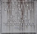 view gallery view galleryE67.8 km |  Chief Ouray and Chipeta Chief Ouray and Chipeta
in Citizen Memorials This Citizen Memorial is inscribed on an obelisk in the Chipeta State Park at the intersection of US Highway 550 and Chepita Road on the southern edge of Montrose, Colorado. posted by: brwhiz location: Colorado date approved: 02/14/2013 last visited: never |
 view gallery view galleryE67.9 km | Chipeta ~ Wife of Chief Ouray in Citizen Memorials This Citizen Memorial is located just northwest of the intersection of US Highway 550 and Chepita Road in Chipeta State Park on the southern edge of Montrose, Colorado. posted by: brwhiz location: Colorado date approved: 02/13/2013 last visited: never |
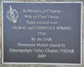
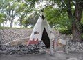 view gallery view galleryE67.9 km |  Ouray and Chipeta's Spring Springhouse Ouray and Chipeta's Spring Springhouse
in Spring Houses This Springhouse, in the form of a teepee, is located just northwest of the intersection of US Highway 550 and Chepita Road in Chipeta State Park on the southern edge of Montrose, Colorado. posted by: brwhiz location: Colorado date approved: 02/14/2013 last visited: never |
 view gallery view galleryE67.9 km |  Montrose Peace Pole Montrose Peace Pole
in Peace Poles This Peace Pole is located at the intersection of US Highway 550 and Chepita Road and the entrance to Chipeta State Park on the southern edge of Montrose, Colorado. posted by: brwhiz location: Colorado date approved: 02/15/2013 last visited: never |
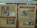
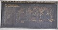 view gallery view galleryE67.9 km |  Building An Empire: The Spanish Frontier ~ Montrose, Colorado Building An Empire: The Spanish Frontier ~ Montrose, Colorado
in Colorado Historical Markers This Historical Marker about the Dominguez-Escalante Expedition of 1776-1777 is one of four located in Chipeta State Park at the intersection of US Highway 550 and Chepita Road on the southern edge of Montrose, Colorado. posted by: brwhiz location: Colorado date approved: 02/16/2013 last visited: never |
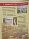 view gallery view galleryE67.9 km | The Dominguez-Escalante Expedition ~ Montrose, Colorado in Colorado Historical Markers This Colorado Historical Marker is located in Chipeta State Park at the intersection of US Highway 550 and Chepita Road on the southern edge of Montrose, Colorado. posted by: brwhiz location: Colorado date approved: 02/14/2013 last visited: never |
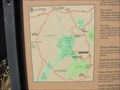 view gallery view galleryW68.1 km |  Canyon Country - Canyonlands of Utah Canyon Country - Canyonlands of Utah
in 'You Are Here' Maps Map of the canyon country at the turn off on Utah 211 heading to Canyonlands National Park. posted by: linkys location: Utah date approved: 11/11/2009 last visited: 01/08/2016 |
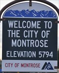 view gallery view galleryE68.1 km |  Montrose, Colorado (Southern Approach) ~ Elevation 5794 Feet Montrose, Colorado (Southern Approach) ~ Elevation 5794 Feet
in Elevation Signs This Elevation Sign is located on the east side of US Highway 550 at the southern city limit of Montrose, Colorado. posted by: brwhiz location: Colorado date approved: 02/12/2013 last visited: never |
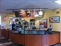 view gallery view galleryNE68.1 km |  A&W - Montrose, Colorado A&W - Montrose, Colorado
in A + W Restaurants This is a combination A&W/LJS. posted by: SageInThyme82 location: Colorado date approved: 09/30/2015 last visited: 10/05/2009 |
 view gallery view galleryE68.4 km |  Applebee's - Oxbow Drive ~ Montrose, Colorado Applebee's - Oxbow Drive ~ Montrose, Colorado
in Applebee's Restaurants This Applebee's Restaurant is located at 1501 Oxbow Drive in Montrose, Colorado. posted by: brwhiz location: Colorado date approved: 02/13/2013 last visited: never |
 view gallery view galleryE68.4 km | Montrose, Colorado 81401 ~ Party Town Postal Center CPU in U.S. Post Offices This Post Office is a Contract Postal Unit located in the Party Town store at 1521 OxBow Drive in Montrose, Colorado. posted by: brwhiz location: Colorado date approved: 10/31/2011 last visited: never |
 view gallery view galleryNE68.6 km |  Montrose,Colorado Railroad Depot Montrose,Colorado Railroad Depot
in Train Stations/Depots Montrose Railroad Depot,Historical Museum posted by: GEO*Trailblazer 1 location: Colorado date approved: 12/10/2006 last visited: 01/29/2012 |
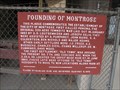 view gallery view galleryNE68.6 km | Founding of Montrose - Montrose, Colorado in Colorado Historical Markers Historical marker giving brief history of the founding of Montrose, Colorado. posted by:  BruceS BruceS location: Colorado date approved: 06/21/2011 last visited: 12/17/2011 |
|