  S8.9 km S8.9 km
|   Yosemite an enduring Treasure CA Yosemite an enduring Treasure CA
in There's a Book About It The cover photo is Upper Yosemite Falls but you can log within the range.
A 10" x 12" color paperback, 50 pgs. 2001 by the Yosemite Association. posted by:  sbcamper sbcamper location: California date approved: 07/09/2009 last visited: 03/30/2014 |
 view gallery view gallery N22.5 km N22.5 km
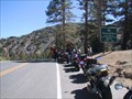
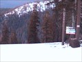
|  Sonora Pass, Elev 9624 Ft Sonora Pass, Elev 9624 Ft
in Elevation Signs Sonora Pass, Highway 108, Sierra Nevada Range, California posted by: michael3900 location: California date approved: 09/17/2008 last visited: 09/11/2011 |
 view gallery view gallery SW23.7 km SW23.7 km
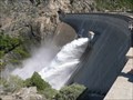
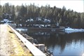
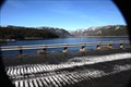
|  O' Shaughnessy Dam O' Shaughnessy Dam
in Water Dams This is the famous Hetch Hetchy Lake and it's dam. The dam is around 435 feet tall and hides a valley that John Muir once thought was as beautiful as Yosemite Valley. posted by: emjc location: California date approved: 05/20/2007 last visited: 06/28/2013 |
 view gallery view gallery E26.6 km E26.6 km
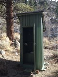
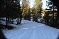
|  Twin Lake, Bridgeport, California Twin Lake, Bridgeport, California
in Outhouses Rest Stop on the hill.. posted by:  grandmabetsy grandmabetsy location: California date approved: 03/02/2014 last visited: 03/02/2014 |
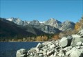 view gallery view galleryE27.4 km |  Crag's Resort, Lower Twin Lake- Bridgeport, CA Crag's Resort, Lower Twin Lake- Bridgeport, CA
in Fishing Holes Lower Twin Lakes Crag's Resort, in large Jeffrey pine trees and sagebrush. Trophy trout are taken annually from Lower Twin Lake, one of the premier fishing lakes in Mono County. posted by: calgriz location: California date approved: 01/21/2010 last visited: 07/10/2010 |
 view gallery view gallery W28.8 km W28.8 km
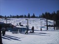
|  Dodge Ridge Dodge Ridge
in Winter Sports Locations Dodge Ridge near Pinecrest California in the Sierra Nevada. posted by: dmchapman location: California date approved: 02/01/2006 last visited: never |
 view gallery view galleryW28.8 km |  Dodge Ridge Ski Area Dodge Ridge Ski Area
in Web Cameras Two controllable webcams available 24/7. posted by: dmchapman location: California date approved: 01/17/2007 last visited: 02/27/2008 |
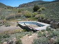
 view gallery view gallerySW29.5 km | Cherry Valley Dam in Water Dams Cherry Valley Dam near Groveland, Ca. posted by: kdczy location: California date approved: 01/19/2011 last visited: 01/17/2011 |
 view gallery view gallerySW29.5 km |  Cherry Lake Boat Launch Cherry Lake Boat Launch
in Boat Ramps Boat launch into Cherry Lake at Cherry Valley Dam, near Groveland, Ca. posted by: kdczy location: California date approved: 01/27/2011 last visited: 01/29/2011 |
 view gallery view gallerySW29.5 km | Cherry Lake in Fishing Holes Cherry Lake, near Groveland, Ca. posted by: kdczy location: California date approved: 01/19/2011 last visited: 01/17/2011 |
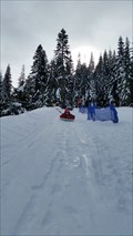 view gallery view galleryW31.9 km |  Leland High Sierra Snow Play - Pinecrest, CA Leland High Sierra Snow Play - Pinecrest, CA
in Sledding Places A sledding park in Pinecrest, CA. posted by: saopaulo1 location: California date approved: 01/26/2016 last visited: never |
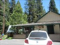
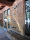 view gallery view galleryW32.2 km |  Pinecrest, CA - 95364 Pinecrest, CA - 95364
in U.S. Post Offices A post office in a resort in Pinecrest, CA. posted by: saopaulo1 location: California date approved: 01/09/2017 last visited: never |
 view gallery view gallery NE32.7 km NE32.7 km
|  Fales Hot Springs Fales Hot Springs
in Hot Springs Abandoned resort off of Hwy 395 in Mono County. posted by: Squirreleen location: California date approved: 04/28/2008 last visited: 06/27/2012 |
 view gallery view gallery SE32.8 km SE32.8 km
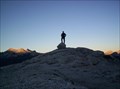
|  Mount Conness Mount Conness
in Summit Registers At 12,590 feet, Mount Conness is the tallest peak in the Sierra Nevada North of Tioga Pass. posted by: Touchstone location: California date approved: 08/22/2007 last visited: never |
 view gallery view galleryW33 km | Strawberry, CA - 95375 in U.S. Post Offices A post office in Strawberry, CA. posted by: saopaulo1 location: California date approved: 01/08/2017 last visited: never |
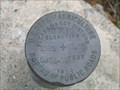 view gallery view gallery NW33.2 km NW33.2 km
|  Clark Fork Rd Clark Fork Rd
in U.S. Benchmarks USDA Bureau of Public Roads disk posted by: dmchapman location: California date approved: 01/29/2006 last visited: 05/07/2011 |
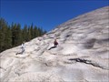 view gallery view gallerySE34.6 km |  Pothole Dome Pothole Dome
in Places of Geologic Significance Pothole Dome in Tuolumne Meadows provides an excellent opportunity to view typical glacial erosional and geomorphologic features and some not so typical ones as well. posted by: TerryDad2 location: California date approved: 01/03/2010 last visited: 02/20/2015 |
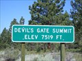 view gallery view galleryNE34.6 km | Devil's Gate Summit 7519 Feet - CA in Elevation Signs Devil's Gate Pass is located in Mono County, CA. This is the highest point on that pass. posted by: Free2bme29 location: California date approved: 07/11/2009 last visited: 09/14/2021 |
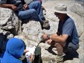
 view gallery view gallerySE36.4 km |  Yosemite NP: Tuolumne Meadows Visitors Center Yosemite NP: Tuolumne Meadows Visitors Center
in Civilian Conservation Corps The CCC was very active in Yosemite National Park between 1933 to 1942. The Tuolumne Meadows Visitors Center is just one of many projects that the CCC performed to make the Park what it is today. posted by: Touchstone location: California date approved: 09/05/2005 last visited: 06/29/2012 |
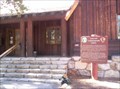 view gallery view gallerySE36.4 km |  Yosemite NP: Tuolumne Meadows Visitors Center Yosemite NP: Tuolumne Meadows Visitors Center
in NPS Passport Cancellation Stations Located in the historic Visitors Center in Tuolumne Meadows. Coordinates were taken at the base of the stairway leading to the front door. posted by: Touchstone location: California date approved: 08/30/2005 last visited: 06/26/2014 |
 view gallery view gallerySE37.2 km |  Lembert Dome Lembert Dome
in Mountain Summits Located within Yosemite National Park, this high point in Tuolumne Meadows offers a 360 degree view for the price of a moderate hike. posted by: Touchstone location: California date approved: 08/30/2005 last visited: 02/20/2015 |
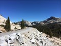
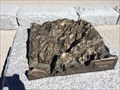 view gallery view galleryS37.3 km |  Olmsted Point Map - Yosemite, CA Olmsted Point Map - Yosemite, CA
in 3D Map Models of Our World and Beyond A 3d map of Yosemite Valley at Olmsted Point. posted by: bluesnote location: California date approved: 10/21/2016 last visited: 10/21/2016 |
 view gallery view galleryS37.3 km |  Tioga Pass - Yosemite, CA Tioga Pass - Yosemite, CA
in Wikipedia Entries The Tioga Pass is the northern most route into Yosemite Valley. It is also the highest, with parts in excess of 9,000 feet in elevation. posted by: bluesnote location: California date approved: 10/21/2016 last visited: 07/24/1984 |
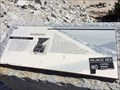 view gallery view galleryS37.3 km |  Avalanche! - Yosemite, CA Avalanche! - Yosemite, CA
in Signs of History One of a few signs of history at Olmsted Point within Yosemite National Park. posted by: bluesnote location: California date approved: 10/20/2016 last visited: 10/20/2016 |
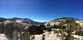 view gallery view galleryS37.3 km |  Olmsted Point - Yosemite, CA Olmsted Point - Yosemite, CA
in Bookcrossing Zones A popular vista point along Tioga Pass Rd within Yosemite National Park. posted by: bluesnote location: California date approved: 01/12/2017 last visited: 01/12/2017 |
|