 view gallery view gallery SW28.3 km SW28.3 km
|   N 38 W 100 ~ SW of Jetmore, Kansas N 38 W 100 ~ SW of Jetmore, Kansas
in Confluence Spots This point of intersection for 38 degrees north latitude and 100 degrees west longitude occurs along a rural road north of Dodge City and a few miles southwest of Jetmore, Kansas. posted by:  brwhiz brwhiz location: Kansas date approved: 05/30/2012 last visited: 08/30/2019 |
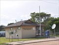 view gallery view gallery SE29.3 km SE29.3 km
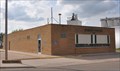
|  Offerle, Kansas 67563 Offerle, Kansas 67563
in U.S. Post Offices This Post Office is located at 116 S Main Street in Offerle, Kansas. posted by: brwhiz location: Kansas date approved: 09/01/2012 last visited: never |
 view gallery view gallerySE29.5 km |  Water Tower - Offerle KS Water Tower - Offerle KS
in Water Towers This water tower is just north of Hwy 50 in Offerle, Kansas. posted by: PeterNoG location: Kansas date approved: 02/14/2011 last visited: 04/29/2012 |
 view gallery view gallerySE29.5 km |  HG1000 ~ OFFERLE MUN WATER TANK HG1000 ~ OFFERLE MUN WATER TANK
in U.S. Benchmarks This benchmark is the top center of the municipal water tank in Offerle, Kansas. posted by: brwhiz location: Kansas date approved: 05/30/2012 last visited: 12/27/2010 |
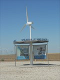 view gallery view gallery S29.9 km S29.9 km
|  Spearville Wind Energy Facility - Spearville, KS Spearville Wind Energy Facility - Spearville, KS
in Windmills The Spearville Wind Energy Facility is a 5,000-acre windmill farm in Spearville, Kansas, USA. posted by: Marine Biologist location: Kansas date approved: 11/19/2011 last visited: never |
 view gallery view galleryS30.7 km | Spearville, Kansas 67876 in U.S. Post Offices This Post Office is located at 302 Main Street in Spearville, Kansas. posted by: brwhiz location: Kansas date approved: 09/01/2012 last visited: never |
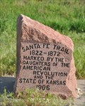 view gallery view gallerySE31.1 km |  Santa Fe Trail Santa Fe Trail
in Kansas Historical Markers This engraved stone marker for the Santa Fe Trail is located in a turnout on the south side of US Highway 50/56 west of Kinsley, Kansas. posted by: brwhiz location: Kansas date approved: 02/06/2013 last visited: never |
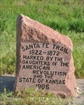 view gallery view gallerySE31.1 km |  Santa Fe Trail at Kinsley, Kansas Santa Fe Trail at Kinsley, Kansas
in Wagon Roads and Trails This engraved stone marker for the Santa Fe Trail is located in a turnout on the south side of US Highway 50/56 west of Kinsley, Kansas. posted by: brwhiz location: Kansas date approved: 02/22/2013 last visited: never |
 view gallery view gallerySE34.6 km |  Midway USA - Kinsley KS Midway USA - Kinsley KS
in Roadside Attractions This roadside attraction is the sign that proclaim that Kinsley, Kansas is "Midway U.S.A.". The distance to New York or to San Francisco is 1561 miles. posted by: PeterNoG location: Kansas date approved: 02/26/2011 last visited: 12/27/2019 |
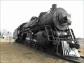 view gallery view gallerySE34.6 km |  AT&SF #3424 - Kinsley KS AT&SF #3424 - Kinsley KS
in Locomotives This steam locomotive is a 3400 Class, Pacific type (4-6-2). It is in a small park in Kinsley, Kansas, where US Hwy 50 and US Hwy 56 join or split, depending on which way you're going. posted by: PeterNoG location: Kansas date approved: 02/27/2011 last visited: 12/27/2019 |
 view gallery view gallerySE35.1 km | Kinsley, Kansas 67547 in U.S. Post Offices This Post Office is located at 717 Marsh Avenue in Kinsley, Kansas. posted by: brwhiz location: Kansas date approved: 09/02/2012 last visited: never |
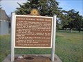
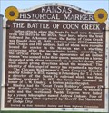 view gallery view gallerySE37.7 km | The Battle of Coon Creek in Kansas Historical Markers This Kansas Historical Marker, that replaced an earlier version in 2012, is located on the south side of US Highway 50 about 2 miles east of Kinsley, Kansas. posted by: brwhiz location: Kansas date approved: 02/06/2013 last visited: never |
 view gallery view gallerySE37.7 km |  The Battle of Coon Creek The Battle of Coon Creek
in Battlefields This Kansas Historical Marker about the Battle of Coon Creek is located on the south side of US Highway 50 about 2 miles east of Kinsley, Kansas. posted by: brwhiz location: Kansas date approved: 02/05/2013 last visited: 08/22/2015 |
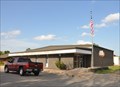
 view gallery view galleryS41.2 km |  Wright Senior Center Wright Senior Center
in Municipal Community Centers This Senior Center is located at 10891 Main Street in Wright, Kansas. posted by: brwhiz location: Kansas date approved: 02/04/2013 last visited: never |
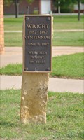 view gallery view galleryS41.2 km |  Wright, Kansas Centennial Wright, Kansas Centennial
in Community Commemoration This centennial marker is located near the northwest corner of the Wright post office located at 10894 Main Street in Wright, Kansas. posted by: brwhiz location: Kansas date approved: 02/09/2013 last visited: never |
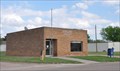 view gallery view galleryS41.2 km | Wright, Kansas 67882 in U.S. Post Offices This Post Office is located at 10894 Main Street in Wright, Kansas. posted by: brwhiz location: Kansas date approved: 09/01/2012 last visited: never |
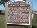 view gallery view gallerySW41.7 km | The Road to Santa Fe - Ford County in Kansas Historical Markers This marker is in a roadside turnout 8 miles northeast of Dodge City, Kansas on US-56, US-50, and US-283. posted by: iconions location: Kansas date approved: 12/01/2008 last visited: 05/01/2005 |
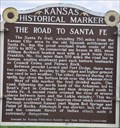 view gallery view gallerySW41.7 km | The Road to Santa Fe in Wagon Roads and Trails This Kansas Historical Marker is located in a turnout on the northeast corner of the intersection of Jewell Road (US Highway 283) and 117 Road (US Highway 50/56) about 8 miles northeast of Dodge City, Kansas. posted by: brwhiz location: Kansas date approved: 02/04/2013 last visited: never |
 view gallery view gallery E41.8 km E41.8 km
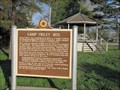
| Camp Criley 1872 - Garfield, Kansas in Kansas Historical Markers Marker giving history of town of Garfield which was originally known as Camp Criley. posted by:  BruceS BruceS location: Kansas date approved: 06/18/2012 last visited: 04/06/2017 |
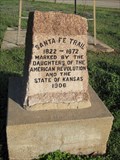 view gallery view galleryE41.8 km | Santa Fe Trail - Garfield, Kansas in Wagon Roads and Trails Stone trail monument in Garfield, Kansas. posted by: BruceS location: Kansas date approved: 06/07/2012 last visited: 04/06/2017 |
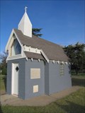 view gallery view galleryE42.2 km |  Garfield Memorial Wayside Chapel - Garfield, Kansas Garfield Memorial Wayside Chapel - Garfield, Kansas
in Waychapels Wayside chapel in a small park on the east side of Garfield, Kansas. posted by: BruceS location: Kansas date approved: 06/08/2012 last visited: 04/06/2017 |
 view gallery view galleryE42.2 km | Garfield Memorial Wayside Chapel - Garfield, Kansas in Kansas Historical Markers Marker for wayside chapel in small park on east side of Garfield, Kansas. posted by: BruceS location: Kansas date approved: 06/18/2012 last visited: 04/06/2017 |
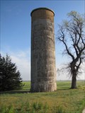 view gallery view galleryE42.3 km |  Downey Memorial Park Silo - Garfield, Kansas Downey Memorial Park Silo - Garfield, Kansas
in Solitary Silos Silo on east side of Garfield, Kansas. posted by: BruceS location: Kansas date approved: 06/07/2012 last visited: 04/06/2017 |
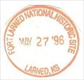 view gallery view galleryE44.1 km |  Fort Larned National Historic Site - Larned, KS Fort Larned National Historic Site - Larned, KS
in NPS Passport Cancellation Stations Fort Larned is a well-preserved fort on the Santa Fe Trail shares a tumultuous history of the Indian Wars era. posted by:  Don.Morfe Don.Morfe location: Kansas date approved: 02/14/2020 last visited: 10/10/2021 |
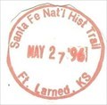 view gallery view galleryE44.1 km | Santa Fe National Historic Trail-Fort Larned KS - Larned, KS in NPS Passport Cancellation Stations The Great Prairie Highway
You can almost hear the whoops and cries of "All's set!" as trail hands hitched their oxen to freight wagons carrying cargo between western Missouri and Santa Fe, New Mexico. posted by: Don.Morfe location: Kansas date approved: 02/25/2020 last visited: 10/10/2021 |
|