 view gallery view gallery W3.2 km W3.2 km
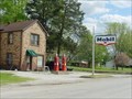
|   Mobil Gas Pumps - Prairie du Rocher, Illinois Mobil Gas Pumps - Prairie du Rocher, Illinois
in Vintage Gasoline Pumps Vintage Mobil gas pumps in Prairie du Rocher, Illinois. posted by:  paulspaper paulspaper location: Illinois date approved: 04/09/2008 last visited: never |
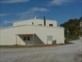
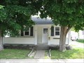
 view gallery view galleryW3.2 km |  Mobil Gas Station - Prairie du Rocher, Illinois Mobil Gas Station - Prairie du Rocher, Illinois
in Vintage Gas Stations Old Mobil gas station in Prairie du Rocher, Illinois. posted by: paulspaper location: Illinois date approved: 04/08/2008 last visited: never |
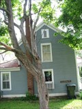
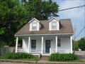
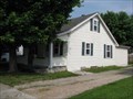
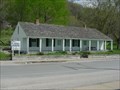 view gallery view galleryW3.2 km |  Creole House - Prairie du Rocher, Illinois Creole House - Prairie du Rocher, Illinois
in U.S. National Register of Historic Places Two hundred year old house in Prairie du Rocher, Illinois. posted by: paulspaper location: Illinois date approved: 05/04/2008 last visited: 06/17/2009 |
 view gallery view galleryW3.2 km |  Creole House - Prairie du Rocher, Illinois Creole House - Prairie du Rocher, Illinois
in Pre-Victorian Historic Homes The Creole House is unique in architecture because it used the French "post in ground" style. The home was built in 1800. posted by: paulspaper location: Illinois date approved: 05/03/2008 last visited: never |
 view gallery view gallery NW5.8 km NW5.8 km
|  Kaskaskia Quarry - Randolph County, Illinois Kaskaskia Quarry - Randolph County, Illinois
in Active Quarries Large limestone quarry in Randolph County, Illinois posted by: paulspaper location: Illinois date approved: 04/09/2008 last visited: never |
 view gallery view gallery SW7.2 km SW7.2 km
|  Land of Wonders - Magnolia Hollow, MO Land of Wonders - Magnolia Hollow, MO
in Lewis and Clark Trail This historical marker is in the Magnolia Hollow Conservation area is the bluff noted by Clark from the river below on December 4, 1803. posted by: S5280ft location: Missouri date approved: 05/17/2008 last visited: 10/24/2008 |
 view gallery view gallery S7.9 km S7.9 km
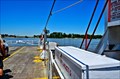
|  Sainte Genevieve / Modoc - Mississippi River - Sainte Genevieve MO Sainte Genevieve / Modoc - Mississippi River - Sainte Genevieve MO
in Ferries and Ferry Landings Launching for St Genevieve, the Mother City of the West, crossing the Mississippi River, landing at Modoc, IL posted by: nomadwillie location: Missouri date approved: 03/09/2013 last visited: 10/29/2015 |
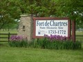
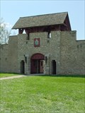 view gallery view galleryW8.4 km | Fort de Chartres - Prairie du Rocher, Illinois in U.S. National Register of Historic Places Reconstructed French Fort of the 1750's. posted by: paulspaper location: Illinois date approved: 09/03/2007 last visited: 09/16/2011 |
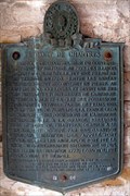 view gallery view galleryW8.5 km |  Fort De Chartres Gateway markers - Prairie de Rocher, IL Fort De Chartres Gateway markers - Prairie de Rocher, IL
in Illinois Historical Markers A pair of markers in the entrance gateway to the rebuilt Fort De Chartres, describing its history. posted by: adgorn location: Illinois date approved: 10/16/2011 last visited: never |
 view gallery view galleryW8.5 km |  "Fort de Chartres" - Prairie du Rocher, IL "Fort de Chartres" - Prairie du Rocher, IL
in Historic Forts Fort de Chartres is the last of three eighteenth-century forts by that name erected near the Mississippi River by France's colonial government. From 1720 to 1763 French administration of the Illinois Country was centered at the forts, built successively over a 40-year period on or near the same site. The stone fort, built in the 1750s and abandoned in 1771, has been partially reconstructed to provide a glimpse of life in Illinois under the French regime. Fort de Chartres State Historic Site, wh posted by: cds231 location: Illinois date approved: 09/29/2007 last visited: 09/16/2011 |
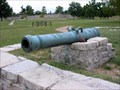 view gallery view galleryW8.5 km |  French Cannon - Fort De Chartres, Prairie de Rocher, IL French Cannon - Fort De Chartres, Prairie de Rocher, IL
in Static Artillery Displays A pair of French cannon in front of the restored French fort in southwestern Illinois. posted by: adgorn location: Illinois date approved: 10/25/2011 last visited: never |
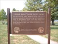 view gallery view galleryW8.5 km | Lewis and Clark in Illinois - Fort de Chartres in Lewis and Clark Trail Commemorative plaque located at historic Fort de Chartres that describes William Clark and several recruits passing this location on their way to Cahokia, IL posted by: cds231 location: Illinois date approved: 09/25/2007 last visited: 09/17/2011 |
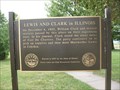 view gallery view galleryW8.5 km | Lewis and Clark in Illinois - Fort De Chartres, Prairie de Rocher, IL in Illinois Historical Markers Large (brass) plaque commemorating William Clark and his recruits who passed by the ruins of Fort De Chartres on their way west, in 1803. posted by: adgorn location: Illinois date approved: 10/16/2011 last visited: never |
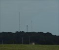 view gallery view galleryS9 km |  KSGM-AM 980 & K287CE-FM 105.3 -- Sainte Genevieve, MO USA KSGM-AM 980 & K287CE-FM 105.3 -- Sainte Genevieve, MO USA
in Radio and Television Transmitter Towers KSGM-AM 980 and its sister FM Translator K287CE-FM 105.3 inform and entertain the folks of Ste. Genevieve MO - and the N tower is also an NGS Benchmark! posted by: Benchmark Blasterz location: Missouri date approved: 01/19/2022 last visited: 01/21/2022 |
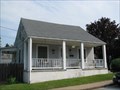
 view gallery view galleryS9.8 km |  Charles LaHaye House - 704 North LaPorte Street - Ste. Genevieve Historic District - Ste. Genevieve, Missouri Charles LaHaye House - 704 North LaPorte Street - Ste. Genevieve Historic District - Ste. Genevieve, Missouri
in NRHP Historic Districts - Contributing Buildings French vertical log styled home in the Ste. Genevieve Historic District in Ste. Genevieve, Missouri. posted by:  BruceS BruceS location: Missouri date approved: 05/30/2008 last visited: never |
 view gallery view galleryS9.8 km | Charles LaHaye House - Ste. Genevieve, Missouri in Pre-Victorian Historic Homes French vertical log styled home in Ste. Genevieve, Missouri. posted by: BruceS location: Missouri date approved: 05/31/2008 last visited: never |
 view gallery view gallery SE10 km SE10 km
|  N 38 W 90 - Near Flinton, IL N 38 W 90 - Near Flinton, IL
in Confluence Spots This confluence point lies in the Mississippi River floodplain of Southern Illinois. Near Chester, IL and Sainte Genevieve, MO posted by: Cap'n YB location: Illinois date approved: 12/22/2007 last visited: 12/19/2007 |
 view gallery view galleryS10 km | Jean Marie Pepin House - 699 North Fourth Street - Ste. Genevieve Historic District - Ste. Genevieve, Missouri in NRHP Historic Districts - Contributing Buildings French vertical log house in the Ste. Genevieve Historic District in Ste. Genevieve, Missouri posted by: BruceS location: Missouri date approved: 05/30/2008 last visited: never |
 view gallery view galleryS10 km | Jean Marie Pepin House - Ste. Genevieve, Missouri in Pre-Victorian Historic Homes French vertical log house in the Ste. Genevieve Historic District in Ste. Genevieve, Missouri posted by: BruceS location: Missouri date approved: 05/30/2008 last visited: never |
 view gallery view galleryS10 km | Louis Carron House - 483 Roberts Street - Ste. Genevieve Historic District - Ste. Genevieve, Missouri in NRHP Historic Districts - Contributing Buildings French vertical log styled home in the Ste. Genevieve Historic District in Ste. Genevieve, Missouri
posted by: BruceS location: Missouri date approved: 05/29/2008 last visited: never |
 view gallery view galleryS10 km | Louis Carron House - Ste. Genevieve, Missouri in Pre-Victorian Historic Homes French vertical log styled home in the Ste. Genevieve Historic District in Ste. Genevieve, Missouri posted by: BruceS location: Missouri date approved: 05/30/2008 last visited: never |
 view gallery view galleryS10 km | Joseph Carron House - 499 Roberts Street - Ste. Genevieve Historic District - Ste. Genevieve, Missouri in NRHP Historic Districts - Contributing Buildings French vertical log house in the Ste. Genevieve Historic District in Ste. Genevieve, Missouri. posted by: BruceS location: Missouri date approved: 05/28/2008 last visited: never |
 view gallery view galleryS10 km | Joseph Carron House - Ste. Genevieve, Missouri in Pre-Victorian Historic Homes French vertical log house in the Ste. Genevieve Historic District in Ste. Genevieve, Missouri. posted by: BruceS location: Missouri date approved: 05/29/2008 last visited: never |
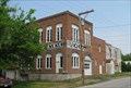
 view gallery view galleryS10 km | Ste. Genevieve Brewery - 555 North Third Street - Ste. Genevieve Historic District - Ste. Genevieve, Missouri in NRHP Historic Districts - Contributing Buildings Former brewery building in the Ste. Genevieve Historic District in Ste. Genevieve, Missouri.
posted by: BruceS location: Missouri date approved: 05/31/2008 last visited: never |
 view gallery view galleryS10 km |  Ste. Genevieve Brewery - Ste. Genevieve, Missouri Ste. Genevieve Brewery - Ste. Genevieve, Missouri
in Breweries Former brewery building in the Ste. Genevieve Historic District in Ste. Genevieve, Missouri. posted by: BruceS location: Missouri date approved: 06/01/2008 last visited: never |
|