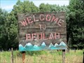
 view gallery view gallery E1.3 km E1.3 km
|   Beulah, Colorado, USA Beulah, Colorado, USA
in Names From the Bible This small town had two prior names before settling on 'Beulah'. posted by:  Outspoken1 Outspoken1 location: Colorado date approved: 08/24/2015 last visited: never |
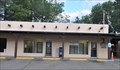
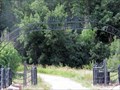 view gallery view galleryE1.6 km |  Moore Ranch - Beulah, CO Moore Ranch - Beulah, CO
in Gates of Distinction These impressive gates are found just before one hits the junction of Hwy 78 (Colo) in Beulah, CO, USA. posted by: Outspoken1 location: Colorado date approved: 09/05/2015 last visited: never |
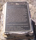 view gallery view gallery NE5.6 km NE5.6 km
|  Fisher's Hole - Beulah, Colorado Fisher's Hole - Beulah, Colorado
in Colorado Historical Markers A marker noting the history of Robert Fisher and the formation of Fisher's Fort that later became Fort Pueblo. posted by: PersonsMD location: Colorado date approved: 11/01/2009 last visited: 08/08/2015 |
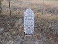
 view gallery view galleryNE5.6 km |  Beulah Time Capsule Beulah Time Capsule
in Time Capsules A time capsule buried in 2001 by the members of this small mountain town in Colorado. posted by: slate6715 location: Colorado date approved: 03/06/2008 last visited: 08/08/2015 |
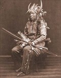
 view gallery view galleryNE5.6 km |  The Solid Muldoon The Solid Muldoon
in Weird Story Locations Memorial for the Solid Muldoon of Beulah fame. posted by: slate6715 location: Colorado date approved: 03/17/2008 last visited: 08/08/2015 |
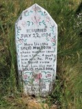 view gallery view galleryNE5.6 km |  Roadside Grave of Solid Muldoon - Beulah, CO Roadside Grave of Solid Muldoon - Beulah, CO
in Roadside Attractions Proof the American public is as gullible then as now. posted by: Outspoken1 location: Colorado date approved: 04/03/2018 last visited: never |
 view gallery view galleryNE5.6 km | Goodpasture, Colorado - Beulah, CO in Colorado Historical Markers This is a newer marker highlighting the early community of Goodpasture, Colorado. posted by: Outspoken1 location: Colorado date approved: 08/09/2015 last visited: never |
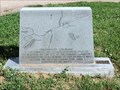
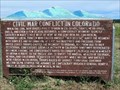 view gallery view galleryNE5.6 km |  Civil War Conflict in Colorado - near Beulah, CO Civil War Conflict in Colorado - near Beulah, CO
in U.S. Civil War Sites Colorado was a territory during the Civil War, but there were credible attempts by Confederate forces to capture the gold fields for revenue and create a western land route for supplies. posted by: Outspoken1 location: Colorado date approved: 08/09/2015 last visited: never |
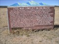 view gallery view galleryNE5.6 km | Civil War Conflict In Colorado in Colorado Historical Markers A marker placed in 1971 noting the role Colorado played in the Civil War of the United States. Located near Pueblo and Beulah, Colorado. Marker was reloacated in 1996. posted by: PersonsMD location: Colorado date approved: 10/28/2009 last visited: 08/08/2015 |
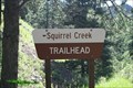 view gallery view gallery W8 km W8 km
|  Squirrel Creek Trailhead - Custer County, CO Squirrel Creek Trailhead - Custer County, CO
in Hiking and walking trailheads Trailhead is at the east end of the Davenport Campground. posted by: mr.volkswagen location: Colorado date approved: 09/24/2015 last visited: 07/13/2019 |
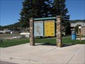 view gallery view gallery SW10.1 km SW10.1 km
| Teller County and Pikes Peak, Woodland Park, CO in Colorado Historical Markers This sign, in Woodland Park, Colorado, provides the history of Pikes Peak and a map of Teller County. posted by: Queens Blessing location: Colorado date approved: 06/20/2010 last visited: 09/15/2012 |
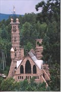 view gallery view galleryW10.3 km |  Bishop Castle Bishop Castle
in Castles Bishop Castle is a one-man construction project by Jim Bishop. The castles contrustion was started in 1969 and is still in constant work. The castle reaches over 160 feet over the ground. posted by:  BobTheSpecialChild BobTheSpecialChild location: Colorado date approved: 10/28/2007 last visited: 07/18/2015 |
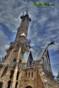 view gallery view galleryW10.3 km | Bishop Castle - Rye, CO in Roadside Attractions Bishop Castle is a very popular Colorado roadside attraction. posted by: mr.volkswagen location: Colorado date approved: 08/19/2015 last visited: never |
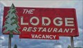 view gallery view gallerySW11.3 km |  The Lodge Restaurant - San Isabel, CO The Lodge Restaurant - San Isabel, CO
in Neon Signs Located next to the Lodge. posted by: mr.volkswagen location: Colorado date approved: 03/17/2020 last visited: never |
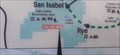 view gallery view gallerySW11.6 km |  YOU ARE HERE! - Lake Isabel Recreation Area - San Isabel, CO YOU ARE HERE! - Lake Isabel Recreation Area - San Isabel, CO
in 'You Are Here' Maps Located at the North Shore Parking area of Lake Isabel. posted by: mr.volkswagen location: Colorado date approved: 10/19/2021 last visited: never |
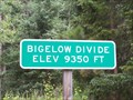 view gallery view galleryW13.5 km |  Bigelow Divide (9,350 ft.) Bigelow Divide (9,350 ft.)
in Elevation Signs Located on Highway 165 at the summit. posted by: mr.volkswagen location: Colorado date approved: 07/26/2009 last visited: 06/09/2013 |
 view gallery view gallery SE16.1 km SE16.1 km
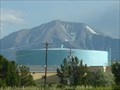
|  WALSENBURG - Water Tank WALSENBURG - Water Tank
in Water Towers WALSENBURG,Colorado Filter Plant Tank posted by: GEO*Trailblazer 1 location: Colorado date approved: 01/23/2007 last visited: 01/23/2007 |
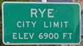 view gallery view gallery S16.6 km S16.6 km
| Rye, Colorado ~ Elevation 6900 Feet in Elevation Signs This Elevation Sign is located on the west side of Boulder Avenue the northern city limits of Rye, Colorado. posted by: brwhiz location: Colorado date approved: 04/02/2013 last visited: never |
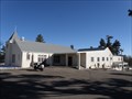
 view gallery view galleryS16.6 km |  Rye, Colorado 81069 Rye, Colorado 81069
in U.S. Post Offices This Post Office is located at 8084 State Highway 165 in Rye, Colorado. posted by: brwhiz location: Colorado date approved: 10/25/2011 last visited: never |
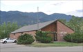
 view gallery view galleryS16.7 km |  St. Aloysius - Rye, CO St. Aloysius - Rye, CO
in Roman Catholic Churches A small church in Rye Colorado posted by: Gershon_ben_Franja location: Colorado date approved: 02/25/2010 last visited: never |
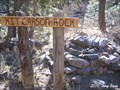 view gallery view gallery NW17.9 km NW17.9 km
|  Kit Carson Rock - Wetmore, CO Kit Carson Rock - Wetmore, CO
in American Guide Series Located on Custer County Rd #389 whichis just off of Highway 96. posted by: mr.volkswagen location: Colorado date approved: 05/17/2010 last visited: 10/02/2010 |
 view gallery view gallerySE18.5 km | Colorado City, Colorado 81019 in U.S. Post Offices This Post Office is located at 4490 Bent Brothers Blvd in Colorado City, Colorado. posted by: brwhiz location: Colorado date approved: 10/25/2011 last visited: never |
 view gallery view gallerySE18.5 km | Chief Cuerno Verde - Colorado City, CO in Colorado Historical Markers This historical event, that happened over 200 years ago, is about where Juan Bautista de Anza, then Governor of New Mexico, marched, camped and fought the feared Comanche Chief Cuerno Verde (Greenhorn) on September 3, 1779, just eighteen miles south of Pueblo, Colorado. Cuerno Verde and several of his warriors were killed, an event which literally changed the course of history in what is now Colorado. posted by: beagle39z location: Colorado date approved: 06/03/2009 last visited: never |
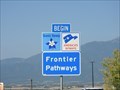 view gallery view gallerySE19.6 km |  Frontier Pathways - Huerfano County, CO Frontier Pathways - Huerfano County, CO
in National Scenic Byways This byway is in Southeast Colorado, a often overlooked part of the state. posted by: Outspoken1 location: Colorado date approved: 02/09/2019 last visited: never |
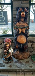 view gallery view gallerySE19.6 km |  Two Bears - Cuerno Verde Rest Area - Colorado City, CO Two Bears - Cuerno Verde Rest Area - Colorado City, CO
in Bear Statues Located at the Cuerno Verde Rest Area in Colorado City, Colorado, just off Interstate 25 Exit 74. posted by: mr.volkswagen location: Colorado date approved: 11/01/2021 last visited: never |
|