  E8 km E8 km
|   Yosemite an enduring Treasure CA Yosemite an enduring Treasure CA
in There's a Book About It The cover photo is Upper Yosemite Falls but you can log within the range.
A 10" x 12" color paperback, 50 pgs. 2001 by the Yosemite Association. posted by:  sbcamper sbcamper location: California date approved: 07/09/2009 last visited: 03/30/2014 |
 view gallery view gallery SW13.4 km SW13.4 km
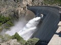
|  O' Shaughnessy Dam O' Shaughnessy Dam
in Water Dams This is the famous Hetch Hetchy Lake and it's dam. The dam is around 435 feet tall and hides a valley that John Muir once thought was as beautiful as Yosemite Valley. posted by: emjc location: California date approved: 05/20/2007 last visited: 06/28/2013 |
 view gallery view gallery W20.9 km W20.9 km
| Cherry Valley Dam in Water Dams Cherry Valley Dam near Groveland, Ca. posted by:  kdczy kdczy location: California date approved: 01/19/2011 last visited: 01/17/2011 |
 view gallery view galleryW20.9 km |  Cherry Lake Boat Launch Cherry Lake Boat Launch
in Boat Ramps Boat launch into Cherry Lake at Cherry Valley Dam, near Groveland, Ca. posted by: kdczy location: California date approved: 01/27/2011 last visited: 01/29/2011 |
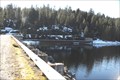
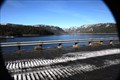 view gallery view galleryW21.1 km |  Cherry Lake Cherry Lake
in Fishing Holes Cherry Lake, near Groveland, Ca. posted by: kdczy location: California date approved: 01/19/2011 last visited: 01/17/2011 |
 view gallery view gallery NW28.6 km NW28.6 km
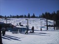
|  Dodge Ridge Dodge Ridge
in Winter Sports Locations Dodge Ridge near Pinecrest California in the Sierra Nevada. posted by: dmchapman location: California date approved: 02/01/2006 last visited: never |
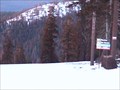 view gallery view galleryNW28.8 km |  Dodge Ridge Ski Area Dodge Ridge Ski Area
in Web Cameras Two controllable webcams available 24/7. posted by: dmchapman location: California date approved: 01/17/2007 last visited: 02/27/2008 |
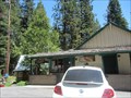
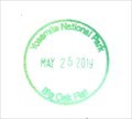 view gallery view gallerySW31.1 km |  Yosemite NP - Big Oak Flat Entrance Station Yosemite NP - Big Oak Flat Entrance Station
in NPS Passport Cancellation Stations This stamp is located at the Big Oak Flat Welcome Center Complex. Ask the ranger at the park gate for the stamp. posted by: DopeyDuck location: California date approved: 06/23/2019 last visited: never |
 view gallery view gallery SE31.1 km SE31.1 km
|  Olmsted Point Map - Yosemite, CA Olmsted Point Map - Yosemite, CA
in 3D Map Models of Our World and Beyond A 3d map of Yosemite Valley at Olmsted Point. posted by: bluesnote location: California date approved: 10/21/2016 last visited: 10/21/2016 |
 view gallery view gallerySE31.1 km |  Olmsted Point Trail - Yosemite, CA Olmsted Point Trail - Yosemite, CA
in Long Distance Hiking Trails A long distance hiking trail on the north side of Yosemite National Park. posted by: bluesnote location: California date approved: 10/20/2016 last visited: 10/20/2016 |
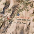 view gallery view gallerySE31.1 km |  Olmsted Point Trail Map - Yosemite, CA Olmsted Point Trail Map - Yosemite, CA
in 'You Are Here' Maps A tail map at Olmsted Point in Yosemite National Park. posted by: bluesnote location: California date approved: 10/21/2016 last visited: 10/21/2016 |
 view gallery view gallerySE31.1 km |  Olmsted Point Trail - Yosemite, CA Olmsted Point Trail - Yosemite, CA
in Hiking and walking trailheads A long distance hiking trail on the north side of Yosemite National Park. posted by: bluesnote location: California date approved: 11/02/2016 last visited: 11/02/2016 |
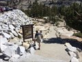
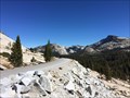
 view gallery view gallerySE31.1 km |  Olmsted Point - Yosemite, CA Olmsted Point - Yosemite, CA
in Bookcrossing Zones A popular vista point along Tioga Pass Rd within Yosemite National Park. posted by: bluesnote location: California date approved: 01/12/2017 last visited: 01/12/2017 |
 view gallery view gallerySE31.1 km |  Olmsted Point - Yosemite, CA Olmsted Point - Yosemite, CA
in Wikipedia Entries A popular vista point along Tioga Pass Rd within Yosemite National Park. posted by: bluesnote location: California date approved: 10/21/2016 last visited: 10/21/2016 |
 view gallery view gallerySE31.1 km |  Olmsted Point - Yosemite, CA Olmsted Point - Yosemite, CA
in Scenic Roadside Look-Outs A popular vista point along Tioga Pass Rd within Yosemite National Park. posted by: bluesnote location: California date approved: 10/21/2016 last visited: 10/21/2016 |
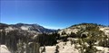 view gallery view gallerySE31.1 km |  Olmsted Point - Yosemite, CA Olmsted Point - Yosemite, CA
in Scenic Overlooks A popular vista point along Tioga Pass Rd within Yosemite National Park. posted by: bluesnote location: California date approved: 10/20/2016 last visited: 10/20/2016 |
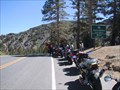
 view gallery view gallerySE31.1 km | Tioga Pass - Yosemite, CA in Wikipedia Entries The Tioga Pass is the northern most route into Yosemite Valley. It is also the highest, with parts in excess of 9,000 feet in elevation. posted by: bluesnote location: California date approved: 10/21/2016 last visited: 07/24/1984 |
 view gallery view gallerySE31.1 km |  Avalanche! - Yosemite, CA Avalanche! - Yosemite, CA
in Signs of History One of a few signs of history at Olmsted Point within Yosemite National Park. posted by: bluesnote location: California date approved: 10/20/2016 last visited: 10/20/2016 |
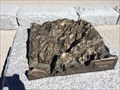
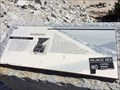
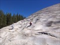 view gallery view gallerySE31.4 km |  Pothole Dome Pothole Dome
in Places of Geologic Significance Pothole Dome in Tuolumne Meadows provides an excellent opportunity to view typical glacial erosional and geomorphologic features and some not so typical ones as well. posted by: TerryDad2 location: California date approved: 01/03/2010 last visited: 02/20/2015 |
 view gallery view galleryNW31.7 km |  Pinecrest, CA - 95364 Pinecrest, CA - 95364
in U.S. Post Offices A post office in a resort in Pinecrest, CA. posted by: saopaulo1 location: California date approved: 01/09/2017 last visited: never |
 view gallery view gallery N32.5 km N32.5 km
|  Sonora Pass, Elev 9624 Ft Sonora Pass, Elev 9624 Ft
in Elevation Signs Sonora Pass, Highway 108, Sierra Nevada Range, California posted by: michael3900 location: California date approved: 09/17/2008 last visited: 09/11/2011 |
 view gallery view galleryNW32.7 km | Strawberry, CA - 95375 in U.S. Post Offices A post office in Strawberry, CA. posted by: saopaulo1 location: California date approved: 01/08/2017 last visited: never |
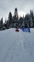 view gallery view galleryNW33 km |  Leland High Sierra Snow Play - Pinecrest, CA Leland High Sierra Snow Play - Pinecrest, CA
in Sledding Places A sledding park in Pinecrest, CA. posted by: saopaulo1 location: California date approved: 01/26/2016 last visited: never |
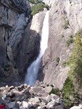 view gallery view gallery S33.2 km S33.2 km
|  Lower Yosemite Falls - Yosemite National Park - California Lower Yosemite Falls - Yosemite National Park - California
in Ansel Adams Photo Hunt These are the Lower Yosemite falls at Yosemite National Park. posted by: GT.US location: California date approved: 02/01/2010 last visited: 03/12/2022 |
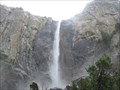 view gallery view galleryS33.2 km |  Yosemite Falls - Yosemite, CA Yosemite Falls - Yosemite, CA
in Official Local Tourism Attractions Here is one of the most iconic waterfalls in the world. posted by: bluesnote location: California date approved: 11/08/2017 last visited: 03/12/2022 |
|